Russian forces advance about 5 km² near Tsvitkove, Zaporizhzhia Oblast, DeepState reports
What happened
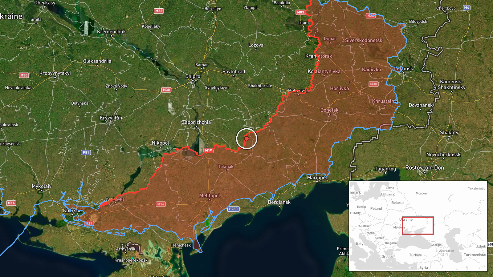
DeepStateMAP, a Ukrainian frontline mapping service, logged a Russian advance of about 5 square kilometres in the Tsvitkove sector of Zaporizhzhia Oblast, southeastern Ukraine, on 21 October 2026 at 00:20 UTC. The update states that no settlement centre changed hands in the sector. The record classifies the event as combat with Russia as actor, but it describes territorial movement only and gives no tactics, units, or casualty figures. No second source, footage, or official statement is attached. The source wording is therefore limited to a change in mapped frontline positions rather than a described engagement.
Context and assessment
Tsvitkove sits on the Zaporizhzhia front, where the line has moved slowly through a chain of small settlements. Related reporting the same day points to sustained pressure in the Huliaipole direction, where Ukrainian Defense Forces reportedly repelled fourteen Russian attacks toward Rybne, Verkhnya Tersa and several neighbouring villages. An earlier entry describes Ukrainian strikes on Russian troop concentrations in Fedorivka, suggesting both sides were active across adjacent sectors. Air activity also appears in the record, with Shahed-type drones transiting Komyshuvakha and Vilnyansk heading west and guided glide bombs directed toward Zaporizhzhia Oblast. Taken together, this may indicate attempts to press or extend positions along several axes at once rather than a single decisive push. A gain of about 5 square kilometres without a settlement change is consistent with incremental advances, although one unconfirmed update cannot establish a trend. Operationally, the mix of ground pressure and glide munitions points to coordinated tasking, but the record does not show how the sectors are linked.
Sources and confidence
Only one channel is attached: DeepStateMAP, with a source count of one and no listed source links. There is no cross-confirmation from another mapping service, Ukrainian military statement, Russian report, or wire agency at the time of writing. The confidence score of 7.5 reflects a credible, specialised tracker, offset by the absence of independent corroboration and the single-channel basis. Confidence would rise with matching reports from a second analytic mapper, official statements, or imagery confirming the advance. It would fall if later updates revised the area, or if the overnight timing noted in a related Fedorivka entry proved to be a date-logging error.
Location
The point is placed at coordinates 47.6863 N, 36.128 E, labelled as a region-level precision match for Tsvitkove, Zaporizhzhia Oblast, with high location confidence in the record. This suggests the marker reflects the settlement area rather than an exact frontline position or facility. The area lies in southeastern Ukraine within the Zaporizhzhia steppe, an open agricultural landscape where small villages are spaced along rural roads and shallow river valleys, which tends to favour broad rather than precise frontline mapping.
Related events nearby
- Ukrainian Defense Forces repelled 14 Russian attacks in the Huliaipole direction toward Rybne, Verkhnya Tersa,2026-10-20 19:06 UTC · Combat · Rybne, Zaporizhzhia Oblast, Ukraine
- Ukrainian Defense Forces struck Russian troop concentrations in Fedorivka, Mykolaivka, Basan, Horlivka, Selydo2026-10-20 08:56 UTC · Combat · Fedorivka, Zaporizhzhia Oblast, Ukraine
- Ukrainian air monitoring: 1 Russian Shahed-type drone passing Komyshuvakha, heading west; 1 Russian Shahed-typ2026-10-20 14:08 UTC · Drone Transit · Komyshuvakha, Ukraine
- Ukrainian air monitoring: 1 Russian guided glide bomb (KAB) heading toward Zaporizhzhya Oblast.2026-10-20 07:53 UTC · Airstrike · Zaporizhzhya Oblast, Ukraine
- Ukrainian air monitoring: 1 Russian guided glide bomb (KAB) heading toward Zaporizhzhya Oblast.2026-10-20 06:59 UTC · Airstrike · Zaporizhzhya Oblast, Ukraine
▶ View this event on the live map

Intel Mapper aggregates open-source reports from monitored Telegram and X channels, geolocates them, cross-checks duplicates across sources and assigns a confidence score. Entries are updated as new confirmations arrive. Read how we verify events.