Israeli drone strikes suspects near Syria border fence in Quneitra
What happened
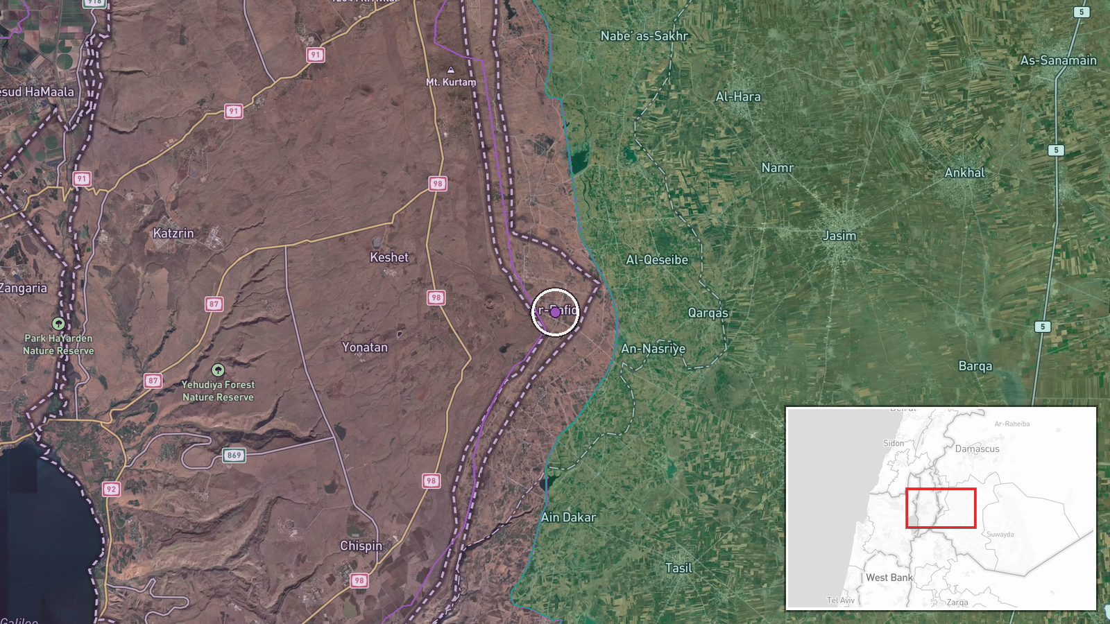
An Israeli unmanned aerial system fired on three individuals who approached the Syria-Israel border fence in the Rafid area of Quneitra Governorate on the night of September 6-7, according to Israeli media. The Israeli military reportedly suspected the group was attempting to plant an explosive device and engaged them with the drone. One suspect was reportedly struck by the munitions; the other two fled eastward into Syrian territory. No confirmation of casualties or device recovery has been reported.
Context and assessment
The strike occurred amid a sharp escalation of Israeli military activity across southern Syria following the collapse of existing security arrangements. On September 6 alone, Israeli forces conducted multiple deployments in Quneitra and Daraa Governorates, including establishment of checkpoints, vehicle incursions, and artillery shelling. The border fence remains a flashpoint for infiltration attempts and cross-border operations. The suspected bomb-planting near the barrier suggests either a deliberate attack on the fence itself or use of the crossing point for weapons movement. The rapid Israeli response indicates heightened alert posture along the frontier.
Sources and confidence
Reported via Telegram channel @AJSyriaNow, citing Israeli media outlet Ma'ariv. Single source limits independent verification; no cross-confirmation from Israeli military statements or Syrian sources documented. Confidence score of 7.5 reflects typical reliability of Israeli media reporting on security incidents but absence of corroborating sources. Additional confirmation from Israeli official statements or imagery would substantially strengthen confidence.
Location
Rafid is a small settlement in Quneitra Governorate in southwestern Syria, approximately 1.5 kilometers east of the Israeli-Syrian demarcation line. The area lies in rolling terrain of the southern Golan Heights region. The border fence runs north-south through this sector, marking the de facto boundary between Israeli-controlled territory and Syrian-held areas.
Related events nearby
- Israeli occupation forces established a temporary checkpoint on the Ofaniya–Khan Arnabah road in northern Qune2026-09-07 16:49 UTC · Deployment · Ofaniya, Quneitra Governorate, Syria
- Families of detainees held in Israeli prisons from Daraa, Quneitra, and Rif Dimashq governorates organized a p2026-09-07 08:20 UTC · Statement · Nab'a al-Fuar, Quneitra Governorate, Syria
- Israeli occupation forces fired three artillery rounds at agricultural lands between Sayda Al-Hanoot and Razan2026-09-07 18:52 UTC · Artillery · Between Sayda Al-Hanoot and Razaniyya villages, Qu
- Israeli airstrike struck Nabatieh, Lebanon. Lebanese reporter injured during live broadcast coverage; stable c2026-09-07 12:12 UTC · Airstrike · Nabatieh, South Governorate, Lebanon
- Syrian Chief of Staff Major General Ali Al-Naasan met with U.S. Joint Task Force Commander Admiral Liam M. Hol2026-09-07 19:46 UTC · Diplomacy · Damascus, Syria
▶ View this event on the live map
Intel Mapper aggregates open-source reports from monitored Telegram and X channels, geolocates them, cross-checks duplicates across sources and assigns a confidence score. Entries are updated as new confirmations arrive. Read how we verify events.