Russian Shahed drone tracked from Cherkasy Oblast toward Kyiv Oblast
What happened
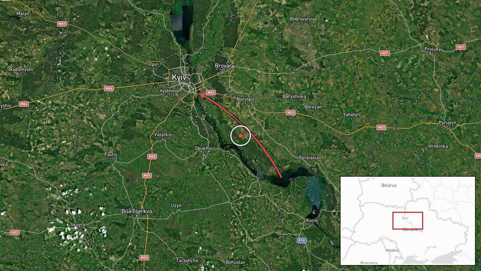
Ukraine's air monitoring service reported one Russian Shahed-type drone in transit from Cherkasy Oblast heading toward Kyiv Oblast on the morning of October 14. The detection was logged at 02:05 UTC. The report originates from the Kyiv air defense command's Telegram channel. No interception or impact was mentioned in the source material, which provided only the tracking observation.
Context and assessment
This drone transit fits an established pattern of Russian aerial reconnaissance and strike operations targeting the Kyiv region. Related reports from the same date show multiple Shahed-variant drones detected in the airspace around Kyiv Oblast and the capital itself within hours, alongside at least one ballistic missile heading the same direction. Russian drone and missile attacks on Kyiv and surrounding areas have been a persistent feature of the conflict, targeting civilian and military infrastructure. The cluster of detections over a short timeframe suggests a coordinated or multi-wave strike activity, though individual transit reports do not confirm successful strikes or defensive outcomes.
Sources and confidence
Report sourced exclusively from Kyiv air defense command's official Telegram channel (@kpszsu). Single-source detection means cross-confirmation with independent monitors is absent from available data. Confidence score of 8.0 reflects the official Ukrainian source's credibility but the lack of corroboration from other tracking networks. Score would rise with independent confirmation; would lower if subsequent reports contradict the track.
Location
Kyiv Oblast, Ukraine, identified at region-level precision (latitude 50.45, longitude 30.52). The origin point in Cherkasy Oblast lies south of the Kyiv region. Geographic precision is low, reflecting detection data typical of air monitoring alerts rather than precise targeting coordinates. The flight path suggests approach from a southwestern direction toward the capital region.
Related events nearby
- Ukrainian air monitoring: 1 Russian jet-powered Shahed (Geran-3) drone heading toward Kyiv.2026-10-14 02:19 UTC · Drone Transit · Kyiv, Ukraine
- Ukrainian air monitoring: 1 Russian jet-powered Shahed (Geran-3) drone passing Kyiv Oblast, heading southwest.2026-10-13 23:25 UTC · Drone Transit · Kyiv Oblast, Ukraine
- Ukrainian air monitoring: 1 Russian ballistic missile heading toward Kyiv.2026-10-13 19:41 UTC · Ballistic Missile · Kyiv, Ukraine
- Ukrainian air monitoring: 1 Russian jet-powered Shahed (Geran-3) drone from Chernihiv Oblast toward Kyiv Oblas2026-10-13 19:34 UTC · Drone Transit · Kyiv Oblast, Ukraine
- Ukrainian air monitoring: 1 Russian jet-powered Shahed (Geran-3) drone over Kyiv Oblast.2026-10-13 14:57 UTC · Drone Transit · Kyiv Oblast, Ukraine
▶ View this event on the live map

Intel Mapper aggregates open-source reports from monitored Telegram and X channels, geolocates them, cross-checks duplicates across sources and assigns a confidence score. Entries are updated as new confirmations arrive. Read how we verify events.