Russian forces advance 2 km near Kalinove in Kupiansk District
What happened
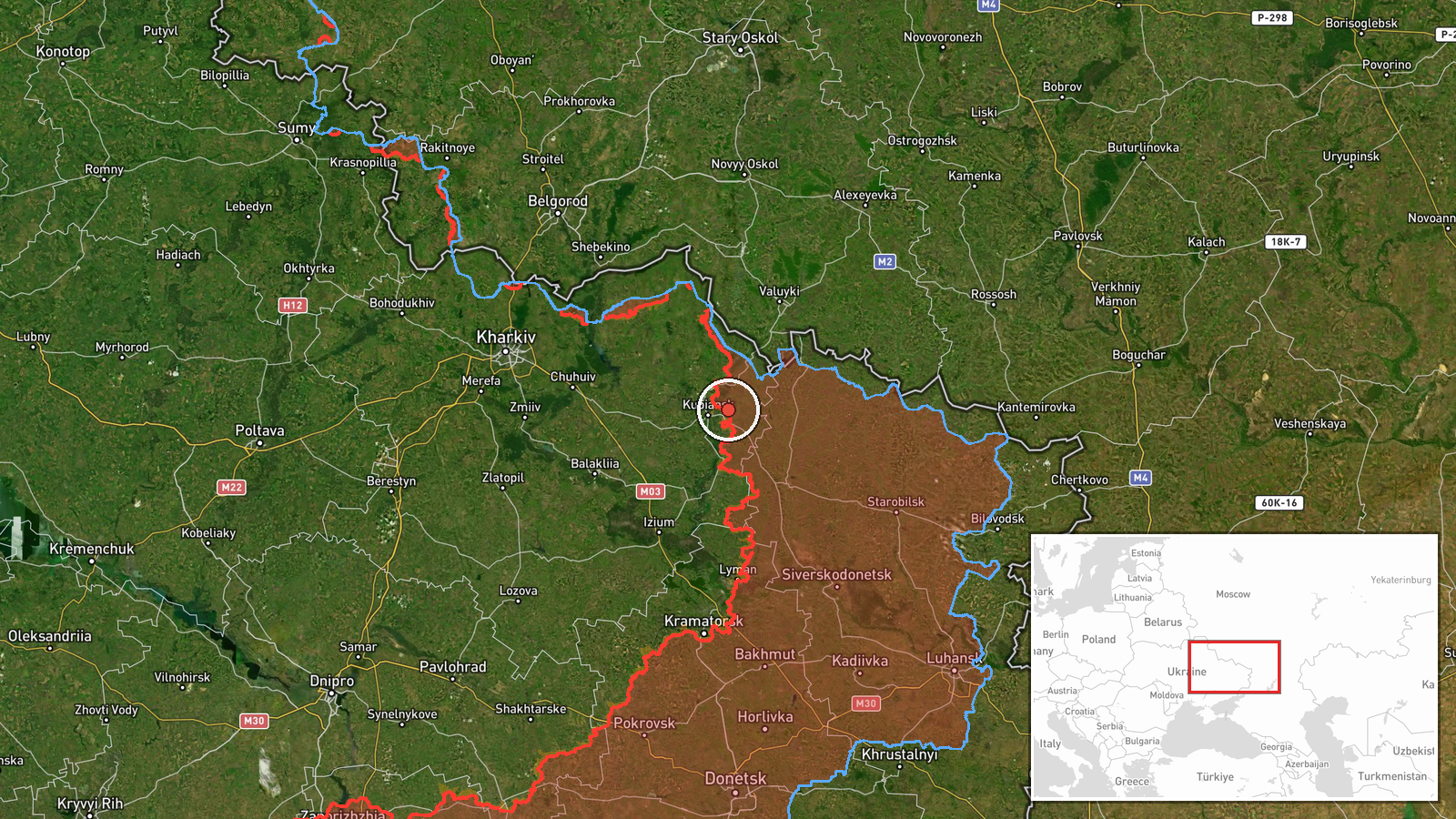
Russian forces reportedly advanced approximately 2 km in the area around Kalinove, a settlement in Kupiansk District, Kharkiv Oblast, according to a Telegram report dated 23 September 2026. The same source suggests the tactical situation may be developing toward an encirclement (Russian military term: kotёl), though specific details of the claimed maneuver were not provided. The report appeared on the morning of 23 September at 04:27 UTC.
Context and assessment
Kalinove lies in the Kupiansk sector of northeastern Kharkiv Oblast, an area of persistent Russian pressure throughout 2026. Recent frontline updates show Russian territorial gains in nearby sectors, including approximately 7 km² in the Minkivka sector as of 22 September, suggesting sustained Russian offensive momentum across this region. Ukrainian forces simultaneously reported ground recovery in the Zapadne sector. The reference to a possible encirclement indicates Russian forces may be attempting to create a tactical pocket, a maneuver consistent with Russian operational doctrine in this sector. However, without confirmation of the encirclement's scope or Ukrainian response, the significance remains unclear.
Sources and confidence
Single source: Telegram channel @supernova_plus on 23 September 2026. No cross-confirmation from other independent channels or official military sources provided. Confidence score of 6.0 reflects this single-source reporting. Confirmation from Ukrainian DeepState mapping, Russian official channels, or video evidence would substantially raise confidence. Retraction or contradicting reports from multiple sources would lower it.
Location
Kalinove is a settlement in Kupiansk District, northeastern Kharkiv Oblast, located at approximately 49.74°N, 37.75°E. It lies in the broader Kupiansk sector, an agricultural area of rolling terrain. The settlement is positioned within an active combat zone marked by frequent tactical shifts and localized advances by both Russian and Ukrainian forces throughout 2026.
Related events nearby
- Ukrainian forces regained ground (~6 km²) in the Zapadne sector per DeepState frontline update. No settlement 2026-09-22 18:20 UTC · Combat · Zapadne sector, Ukraine
- Zapadne reported liberated by Ukrainian forces (per DeepStateMAP frontline update).2026-09-22 18:20 UTC · Capture · Zapadne
- Russian forces advanced (~7 km²) in the Minkivka sector per DeepState frontline update. No settlement center c2026-09-22 18:20 UTC · Combat · Minkivka sector, Ukraine
- Dozens of Ukrainian FPV drones documented waiting near front line in Donetsk, filmed by Russian drone operator2026-09-22 13:25 UTC · Deployment · Donetsk Oblast, Ukraine
▶ View this event on the live map
Intel Mapper aggregates open-source reports from monitored Telegram and X channels, geolocates them, cross-checks duplicates across sources and assigns a confidence score. Entries are updated as new confirmations arrive. Read how we verify events.