Ukraine reports 15 Russian assaults repelled around Kostiantynivka and nearby villages on 17 October 2026
What happened
Ukraine's General Staff reported through its Telegram channel that, as of 22:00 on 17 October 2026, Ukrainian Defence Forces had repelled 15 Russian assaults in the Kostiantynivka direction. The attacks were reported both in the area of the town of Kostiantynivka and toward the villages of Novoselivka, Mykolaipillia, Raiskyi, Hruzkyi, Vilnyi and Kucherovyi Yar. The original Ukrainian wording describes the attacks as 'ворожі штурми', a term used for assaults on Ukrainian positions. The statement gives no casualty figures, equipment losses, or details of how far attacking units advanced. The event is logged at 19:03 UTC, and Russia is named as the actor because the report describes enemy assaults against Ukrainian lines.
Context and assessment
Kostiantynivka sits on the approaches to the Druzhkivka and Kramatorsk-Sloviansk urban cluster, which is why it has been a sustained focus of Russian ground pressure in Donetsk Oblast. The villages named in the report lie around the town, so the list suggests attacks on several axes at once rather than a single breakthrough effort. The same day's related events point to activity across the wider Donetsk front. A Ukrainian General Staff report describes 30 Russian attacks on the Pokrovsk axis, and another reports five attacks on the Lyman axis. Near Yampil', estimated to be on the front line, a Ukrainian drone reportedly struck a Russian pipeline used by the army, while a separate FPV drone attack was reportedly aimed at a Mi-28 helicopter. A third claim of an interceptor drone hitting a Russian attack helicopter is unverified. Taken together, the reports suggest sustained, multi-axis Russian infantry pressure paired with Ukrainian drone strikes on logistics and aviation. These indicators are hedged because each comes from a single channel and the statements do not provide independent confirmation of outcomes.
Sources and confidence
The event rests on one source, the Telegram channel of the Ukrainian General Staff. No independent outlet, satellite imagery, or geolocated video is attached to confirm the claim, so cross-confirmation is absent. The confidence score is low because the figure of 15 repulsed assaults comes from the attacking side's own official reporting and cannot be verified against Russian statements or ground reporting. Confidence would rise with corroboration from regional officials, independent monitoring groups, or geolocated footage showing fighting at the named villages. It would fall further if later official updates revised the count or if the named settlements were shown not to be the locations of the engagements.
Location
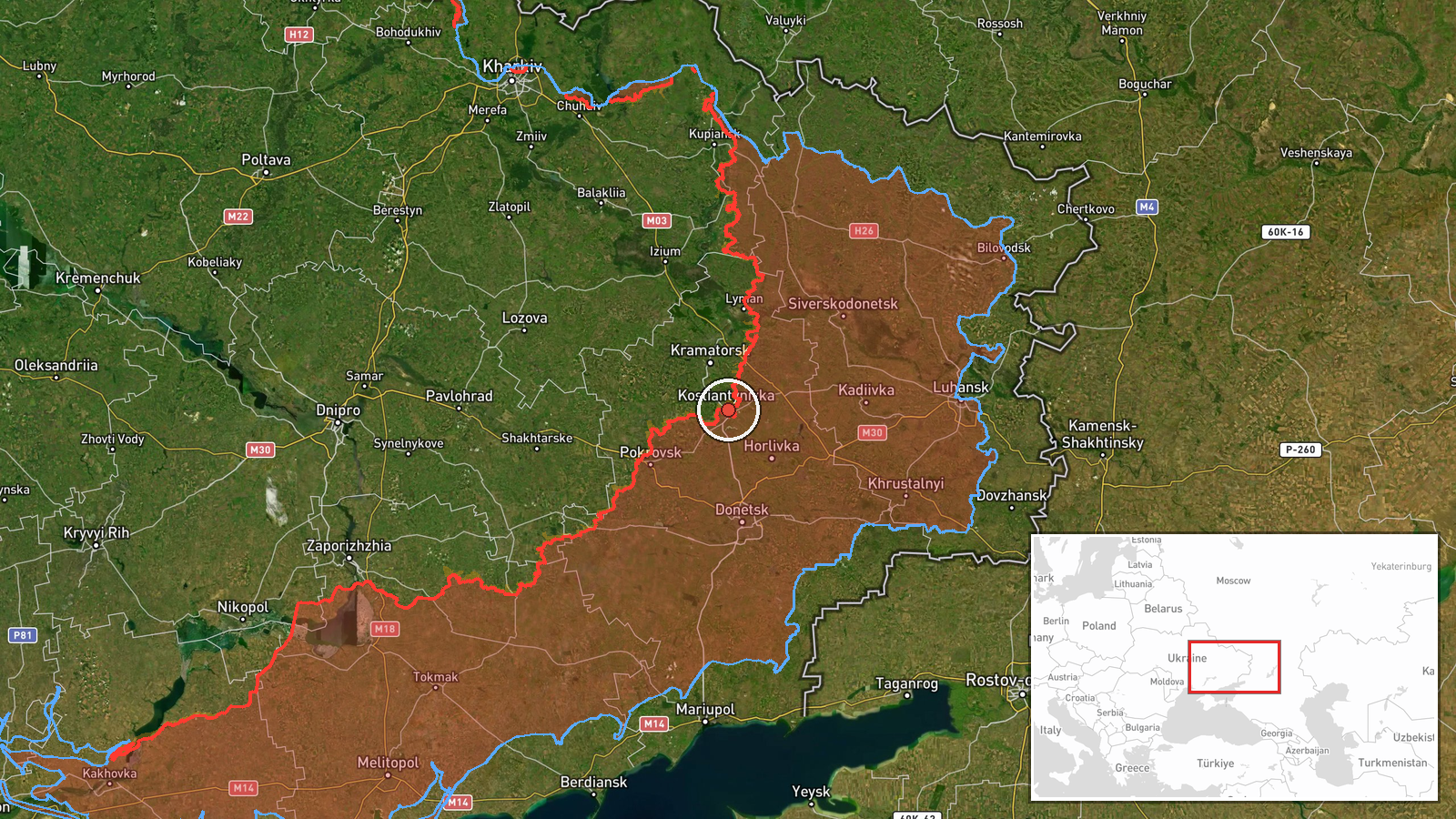
The location is recorded at settlement level, centred on Kostiantynivka in Donetsk Oblast, Ukraine, at roughly 48.527 N, 37.706 E. The villages named in the report are not separately geolocated, so their positions are not shown on the map. Kostiantynivka lies in a largely open, low-lying landscape of steppe farmland, with ravines, reservoirs and small river valleys cutting through the area. Those features shape movement and cover for infantry, and they are part of why the surrounding settlements are important on the front.
Related events nearby
- Ukrainian heavy bombardment UAVs dropped 16 munitions on a pipeline used by the Russian army, destroying it in2026-10-17 10:08 UTC · UAS Strike · Near Yampil', Donetsk, Ukraine (front line, estima
- Ukrainian forces reportedly targeted a Russian Mi-28 attack helicopter with an FPV kamikaze drone. Location an2026-10-16 22:10 UTC · FPV Drone · Near Yampil', Donetsk, Ukraine (front line, estima
- Video reportedly shows Ukrainian jet-powered interceptor drones hunting and hitting a Russian attack helicopte2026-10-17 13:08 UTC · Aircraft Shootdown · Near Yampil', Donetsk, Ukraine (front line, estima
- Ukrainian General Staff reports Ukrainian forces repelled five Russian attacks on the Lyman axis around Lyman,2026-10-17 05:09 UTC · Combat · Lyman, Donetsk Oblast, Ukraine
- Ukrainian General Staff reports 30 Russian attacks on the Pokrovsk axis as of 08:00 on 17.10.2026, across ten 2026-10-17 05:08 UTC · Combat · Near Pokrovsk, Donetsk, Ukraine (front line, estim
▶ View this event on the live map

Intel Mapper aggregates open-source reports from monitored Telegram and X channels, geolocates them, cross-checks duplicates across sources and assigns a confidence score. Entries are updated as new confirmations arrive. Read how we verify events.