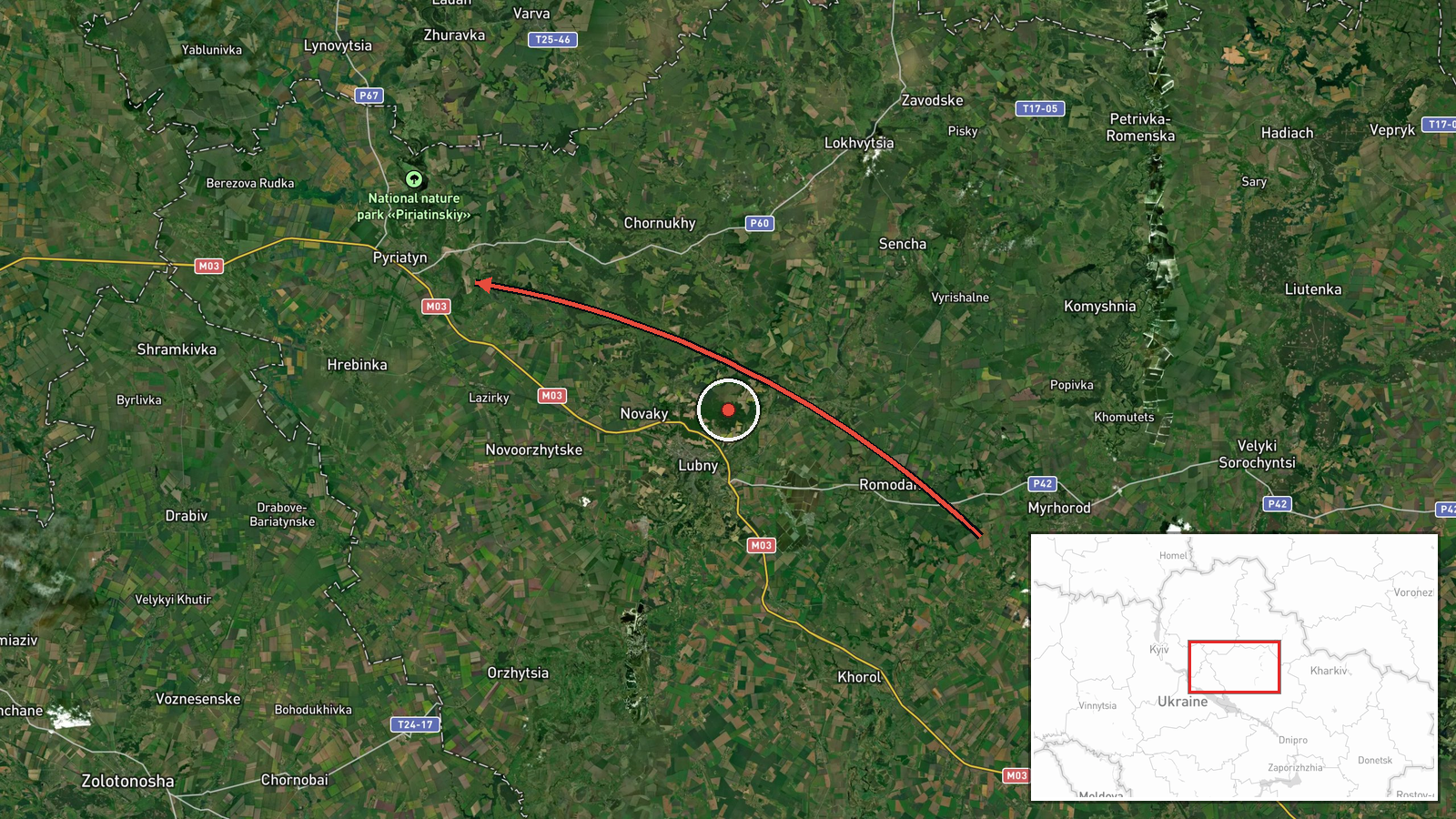
Russian jet-powered Shahed drone tracked toward Pyryatyn in Poltava Oblast
What happened
Ukrainian air monitoring channels reported detection of a single Russian jet-powered Shahed (Geran-3) unmanned aerial vehicle in flight from Poltava Oblast on 13 October at approximately 13:30 UTC, with a reported direction toward Pyryatyn. The report was issued by the Kyiv Post Sourcing Team (@kpszsu) via Telegram. No immediate outcome or interception was reported in the available data.
Context and assessment
Pyryatyn lies in central Poltava Oblast, an area that has experienced sustained Russian air operations. This sighting occurs amid a wider Ukrainian air defense campaign: on 13 October alone, Ukraine's General Staff documented 90 Russian airstrikes and deployment of 9,516 kamikaze drones across the country. Ukrainian fighter assets, including MiG-29s, have engaged Russian attack drones in recent hours using air-to-air missiles. The appearance of a Shahed-type drone in this corridor suggests Russia continues mixed drone operations targeting infrastructure and military positions in rear areas, though specific intent for this individual asset cannot be determined from available reporting.
Sources and confidence
Single-source reporting from Telegram channel @kpszsu (Kyiv Post Sourcing Team). No cross-confirmation from other independent monitors or Ukrainian official statements in provided data. Confidence score of 8.0 reflects the established credibility of the monitoring channel and consistency with documented Russian air activity patterns on the same date, though lack of multiple independent sources prevents higher certainty.
Location
Pyryatyn is a settlement located in central Poltava Oblast, northeastern Ukraine, approximately 190 km east of Kyiv. Positioned at coordinates 50.24°N, 32.52°E, it sits in relatively flat terrain characteristic of the region. The settlement has historical military and industrial significance within Ukrainian territory.
Related events nearby
- Ukrainian air monitoring: 1 Russian jet-powered Shahed (Geran-3) drone heading toward Pereiaslav.2026-10-13 13:32 UTC · Drone Transit · Pereiaslav, Ukraine
- Ukrainian General Staff reports 203 combat engagements in past 24 hours (as of 08:00 13 Oct 2026). Russia cond2026-10-13 05:04 UTC · Report · Ukraine
- Ukrainian air monitoring: 1 Russian jet-powered Shahed (Geran-3) drone from Chernihiv Oblast toward Kozelets.2026-10-13 13:49 UTC · Drone Transit · Kozelets, Ukraine
- Ukrainian air monitoring: 1 Russian jet-powered Shahed (Geran-3) drone over Kharkivskyi Masyv, Kyiv.2026-10-13 14:20 UTC · Drone Transit · Kharkivskyi Masyv, Kyiv, Ukraine
- Ukrainian MiG-29 fighter jet shot down a Russian attack drone using an R-73 air-to-air missile. Cockpit footag2026-10-13 08:40 UTC · Drone Shootdown · Ukraine (location not reported)
▶ View this event on the live map

Intel Mapper aggregates open-source reports from monitored Telegram and X channels, geolocates them, cross-checks duplicates across sources and assigns a confidence score. Entries are updated as new confirmations arrive. Read how we verify events.