Russian jet-powered drones transit Chornobyl exclusion zone heading west toward central Ukraine
What happened
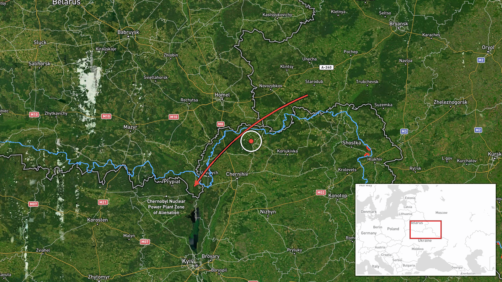
Ukrainian air monitoring reported multiple Russian Shahed jet-powered drones (also known as Geran-3) transiting through the Chornobyl exclusion zone on October 13 at approximately 14:11 UTC, flying westward toward targets in central Ukraine. The report, issued by the Ukrainian air defense command (@kpszsu on Telegram), indicates the drones originated from an estimated launch area in Russia's Bryansk Oblast. Related reports from the same period show individual Shahed drones tracked toward multiple settlements including Dymer, Kozelets, and Hostomel.
Context and assessment
The Chornobyl exclusion zone, spanning roughly 2,600 square kilometers around the defunct nuclear power plant, has become a recurring transit corridor for Russian strike drones targeting western and central Ukrainian positions. Its relatively low air defenses and radar coverage make it an attractive route for deep penetration strikes. The October 13 pattern of multiple simultaneous Shahed transits—documented heading toward Dymer, Kozelets, and Hostomel across a 25-minute window—suggests a coordinated multi-target strike package. This operational tempo aligns with Russian autumn campaigning to pressure Ukrainian logistics and civilian infrastructure. The variety of targets across northern Kyiv and Chernihiv oblasts may indicate either dispersed targeting or attempts to saturate Ukrainian air defenses.
Sources and confidence
Source count: one. Reported solely by Ukrainian air defense command channel @kpszsu on Telegram. Cross-confirmation exists through related Shahed transit reports from the same time window toward named settlements (Dymer, Kozelets, Hostomel), which increases confidence in the exclusion zone transit claim. Confidence score of 8.0 reflects single-channel reporting but corroborating simultaneous drone activity. Higher confirmation would require independent Russian acknowledgment or secondary Ukrainian sources; lower scores would reflect contradictory evidence.
Location
The Chornobyl exclusion zone straddles Kyiv and Chernihiv oblasts in northern Ukraine, centered approximately 130 kilometers north-northwest of Kyiv city. Geo-precision is regional rather than specific (high confidence boundary). The zone encompasses the defunct Chornobyl Nuclear Power Plant on the Pripyat River. Drones transiting westward from this location would target settlements and infrastructure across central Ukrainian territory, including the settlements named in related reports (Dymer, Hostomel) northwest of Kyiv.
Related events nearby
- Ukrainian air monitoring: 1 Russian jet-powered Shahed (Geran-3) drone passing Chornobyl, heading toward Dymer2026-10-13 13:47 UTC · Drone Transit · Dymer, Ukraine
- Ukrainian air monitoring: 1 Russian jet-powered Shahed (Geran-3) drone from Kyiv Oblast toward Dymer.2026-10-13 13:26 UTC · Drone Transit · Dymer, Ukraine
- Ukrainian air monitoring: 1 Russian jet-powered Shahed (Geran-3) drone from Chernihiv Oblast toward Kozelets.2026-10-13 13:49 UTC · Drone Transit · Kozelets, Ukraine
- Ukrainian air monitoring: 1 Russian jet-powered Shahed (Geran-3) drone from Kyiv Oblast toward Hostomel.2026-10-13 13:27 UTC · Drone Transit · Hostomel, Ukraine
- Ukrainian air monitoring: 1 Russian jet-powered Shahed (Geran-3) drone from Kyiv Oblast toward Velyka Dymerka.2026-10-13 14:46 UTC · Drone Transit · Velyka Dymerka, Ukraine
▶ View this event on the live map

Intel Mapper aggregates open-source reports from monitored Telegram and X channels, geolocates them, cross-checks duplicates across sources and assigns a confidence score. Entries are updated as new confirmations arrive. Read how we verify events.