Russian Geran-3 drone tracked toward Myronivka in Kyiv region
What happened
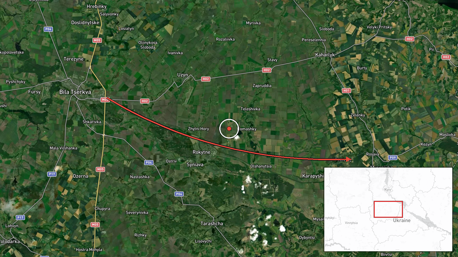
Ukrainian air monitoring detected one Russian jet-powered Shahed drone, identified as a Geran-3 model, passing over Bila Tserkva and heading toward Myronivka on October 15 at 16:56 UTC. The report was published by the Kyiv regional military administration via Telegram. Geran-3 drones are air-launched cruise munitions with extended range compared to earlier variants, typically employed in strikes on infrastructure and populated areas.
Context and assessment
Myronivka lies approximately 80 kilometers south of Kyiv and has been a recurring target during Russian aerial campaigns. This sighting occurred within hours of multiple other Geran-3 transits tracked across the Kyiv region on the same day, including passes near Kaharlyk, Vasylkiv, Obukhiv, and Uzyn. Ukrainian intelligence had warned on October 14 of preparations for a large-scale missile and drone assault. The concentration of jet-powered drone activity in the Kyiv region suggests a coordinated wave targeting multiple locations or critical infrastructure, consistent with Russian patterns of distributed strikes designed to overwhelm air defenses.
Sources and confidence
Report sourced from Telegram channel @kpszsu (Kyiv regional military administration). Single-channel reporting with no cross-confirmation noted; confidence score of 8.0 reflects consistency with broader attack pattern detected that day and institutional credibility of the source. Confirmation would increase confidence; absence of interception claims does not confirm or deny impact.
Location
Myronivka is a settlement in Kyiv Oblast, central Ukraine, located at approximately 49.66°N, 30.98°E. The town sits in agricultural terrain roughly 80 kilometers south of Kyiv proper. Bila Tserkva, mentioned as a reference point for the drone's northward path, lies roughly 30 kilometers to the north.
Related events nearby
- Ukrainian air monitoring: 2+ Russian jet-powered Shahed (Geran-3) drones heading toward Kaharlyk.2026-10-15 14:55 UTC · Drone Transit · Kaharlyk, Ukraine
- Intelligence suggests Russia is preparing a large-scale missile and drone attack on Ukraine. Report indicates 2026-10-14 20:00 UTC · Statement · Ukraine
- Ukrainian air monitoring: 1 Russian jet-powered Shahed (Geran-3) drone heading toward Uzyn.2026-10-15 02:27 UTC · Drone Transit · Uzyn, Ukraine
- Ukrainian air monitoring: 1 Russian jet-powered Shahed (Geran-3) drone heading toward Obukhiv.2026-10-15 17:42 UTC · Drone Transit · Obukhiv, Ukraine
- Ukrainian air monitoring: 1 Russian jet-powered Shahed (Geran-3) drone heading toward Obukhiv.2026-10-15 14:58 UTC · Drone Transit · Obukhiv, Ukraine
▶ View this event on the live map

Intel Mapper aggregates open-source reports from monitored Telegram and X channels, geolocates them, cross-checks duplicates across sources and assigns a confidence score. Entries are updated as new confirmations arrive. Read how we verify events.