Multiple Russian Shahed drones tracked toward Kyiv Oblast from Cherkasy region
What happened
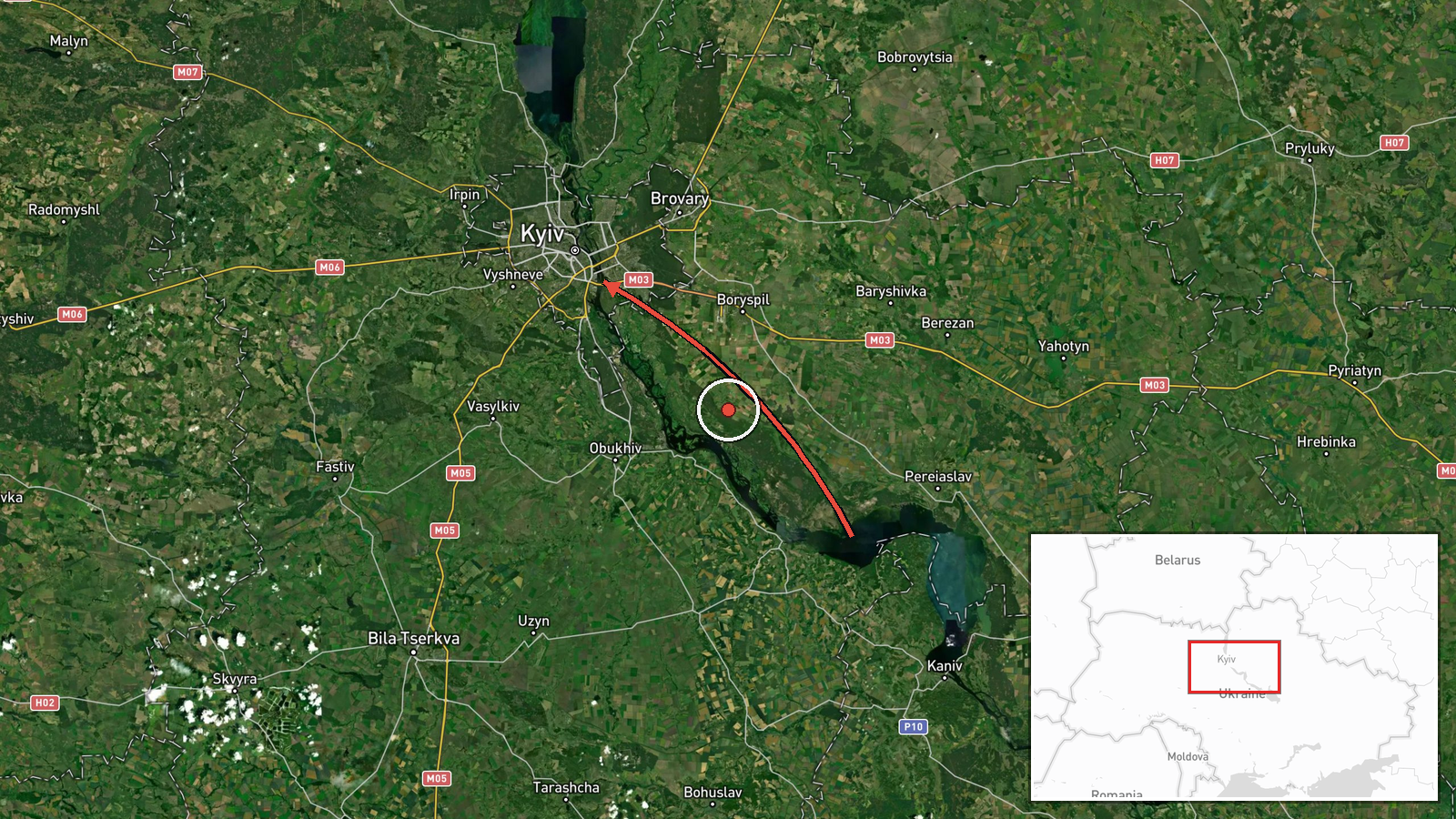
Ukrainian air monitoring detected two or more Russian jet-powered Shahed (Geran-3) drones transiting from Cherkasy Oblast in the direction of Kyiv Oblast on October 15, reportedly passing near the settlement of Myronivka. The report was issued at 17:32 UTC by the Kyiv Civil Protection service. This sighting occurred as part of a sequence of drone transits observed throughout the day, with similar contacts reported at multiple points between 12:53 and 16:38 UTC.
Context and assessment
Kyiv and its surrounding oblast remain consistent targets for Russian drone strikes, reflecting both the capital's military and political significance and its vulnerability to unmanned systems launched from deeper in Russian-controlled territory. The Shahed-136/Geran-3, a loitering munition with jet propulsion and extended range, has become a signature weapon in the Russian air campaign against Ukrainian rear areas. The detection of multiple separate waves over several hours on October 15 suggests a sustained or coordinated operation. Such patterns typically precede or accompany strikes on critical infrastructure, military facilities, or administrative centers in the Kyiv region, though the final impact or intercept status is not detailed in available reporting.
Sources and confidence
Report sourced from Telegram channel @kpszsu (Kyiv Civil Protection service). Single-source reporting with low geographic precision limits confidence to 8.0 out of 10. Cross-confirmation appears limited; confidence would rise with independent radar or additional service confirmations and would fall if subsequent reports contradict the transit vector or timing.
Location
Coordinates place the report in Kyiv Oblast at regional precision. The reference to Myronivka settlement, located northwest of Kyiv city, helps narrow the drone transit corridor. The originating launch area is identified as Cherkasy Oblast to the south, indicating the typical southern approach vector used by Russian strikes on the capital.
Related events nearby
- Ukrainian air monitoring: 2+ Russian jet-powered Shahed (Geran-3) drones heading toward Kyiv.2026-10-15 18:10 UTC · Drone Transit · Kyiv, Ukraine
- Ukrainian air monitoring: 2+ Russian jet-powered Shahed (Geran-3) drones over Kyiv.2026-10-15 16:38 UTC · Drone Transit · Kyiv, Ukraine
- Ukrainian air monitoring: 1 Russian jet-powered Shahed (Geran-3) drone from Cherkasy Oblast toward Kyiv Oblast2026-10-15 16:24 UTC · Drone Transit · Kyiv Oblast, Ukraine
- Ukrainian air monitoring: 1 Russian jet-powered Shahed (Geran-3) drone from Cherkasy Oblast toward Kyiv Oblast2026-10-15 14:01 UTC · Drone Transit · Kyiv Oblast, Ukraine
- Ukrainian air monitoring: 2+ Russian jet-powered Shahed (Geran-3) drones heading toward Kyiv.2026-10-15 13:56 UTC · Drone Transit · Kyiv, Ukraine
▶ View this event on the live map

Intel Mapper aggregates open-source reports from monitored Telegram and X channels, geolocates them, cross-checks duplicates across sources and assigns a confidence score. Entries are updated as new confirmations arrive. Read how we verify events.