Ukrainian Air Force reports one Shahed-type drone heading toward Luhyny, Zhytomyr Oblast
What happened
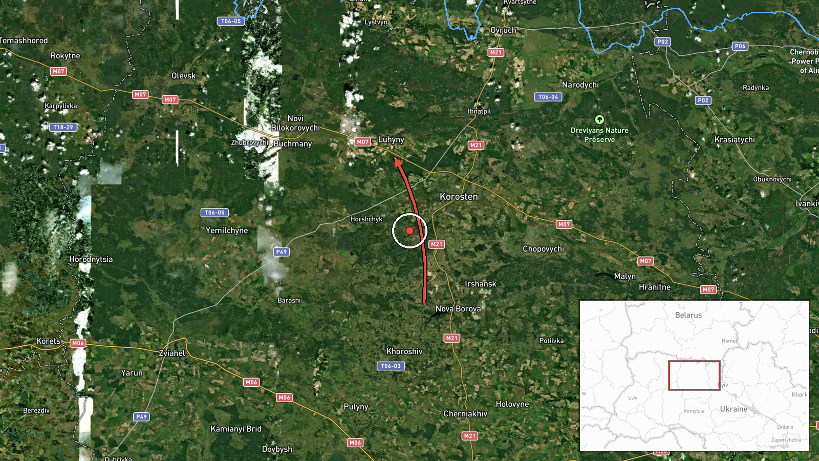
The Ukrainian Air Force's Telegram channel, @kpszsu, reported at 09:29 UTC on 17 October 2026 that one Russian Shahed-type strike drone was moving toward Luhyny in Zhytomyr Oblast. The original Ukrainian post describes it as an "Ударний БпЛА" (strike unmanned aerial vehicle) and says it was approaching from the east. The English summary frames the origin as Zhytomyr Oblast. The alert names the settlement as the target direction and does not identify a specific facility. The source describes no impact, damage, casualties, or interception. As a single-channel air monitoring notice, it reports a trajectory and a warning rather than a confirmed strike.
Context and assessment
Luhyny lies in northern Zhytomyr Oblast, close to the city of Korosten, which functions as a regional rail and road junction and has hosted military-related infrastructure. The alert fits a clear recent pattern. Five earlier drone transit reports were logged between 16:01 UTC on 16 October and 08:36 UTC on 17 October, all directed toward Korosten, and two of them, at 00:53 and 01:23, identified jet-powered Geran-3 variants. The steady cadence of single drones along a corridor through Zhytomyr Oblast suggests sustained probing or harassment of the area rather than one isolated raid. The shift in named destination to Luhyny could reflect a route adjustment, a diversion, or a drone whose heading changed during flight. Alternatively, the naming may simply reflect how the air force describes a track that passes near a different settlement. Taken together, the sequence may indicate continued use of cheap, repeated single-drone flights to stretch air defense attention across the region, but the data alone cannot confirm intent or a specific target set.
Sources and confidence
All information comes from one channel, the official Ukrainian Air Force Telegram account @kpszsu, and no second source in the data independently confirms the track. The confidence score of 8.0 reflects the official origin of the post, its precise timestamp, a settlement-level location with high geographic confidence, and consistency with the surrounding alert series. It is held below the maximum because there is only one source, no independent verification of the track, and no follow-up update in the data. Confidence would rise with corroboration from regional military administration statements, independent monitoring accounts, or an air force update confirming the drone's end point. It would fall if the alert were revised, withdrawn, or reclassified.
Location
The location is a settlement-level match for Luhyny, placed at approximately 51.079 N, 28.399 E, with high location confidence. It was determined from the settlement name in the alert rather than from any facility reference. The area lies in the Polissia lowlands of northern Zhytomyr Oblast, a region of forest, farmland, and wetland. Korosten, the main reference point in the related alerts, lies to the southeast, and the surrounding road and rail corridors are a notable feature of the local geography.
Related events nearby
- Ukrainian air monitoring: 1 Russian Shahed-type drone from Zhytomyr Oblast toward Korosten.2026-10-17 08:36 UTC · Drone Transit · Korosten, Ukraine
- Ukrainian air monitoring: 1 Russian Shahed-type drone from Zhytomyr Oblast toward Korosten.2026-10-17 06:24 UTC · Drone Transit · Korosten, Ukraine
- Ukrainian air monitoring: 1 Russian jet-powered Shahed (Geran-3) drone from Zhytomyr Oblast toward Korosten.2026-10-17 01:23 UTC · Drone Transit · Korosten, Ukraine
- Ukrainian air monitoring: 1 Russian jet-powered Shahed (Geran-3) drone heading toward Korosten.2026-10-17 00:53 UTC · Drone Transit · Korosten, Ukraine
- Ukrainian air monitoring: 1 Russian Shahed-type drone heading toward Korosten.2026-10-16 17:01 UTC · Drone Transit · Korosten, Ukraine
▶ View this event on the live map

Intel Mapper aggregates open-source reports from monitored Telegram and X channels, geolocates them, cross-checks duplicates across sources and assigns a confidence score. Entries are updated as new confirmations arrive. Read how we verify events.