Jet-powered Geran-3 drone reported from Donetsk Oblast toward Blyzniuky, Kharkiv direction
What happened
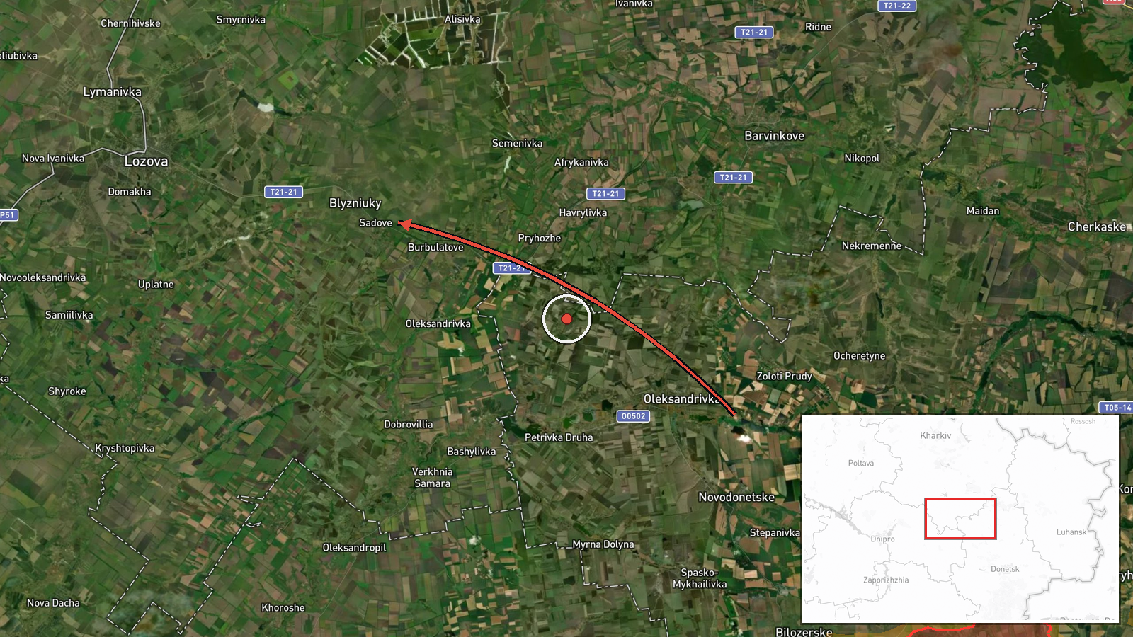
Ukrainian air monitoring reported one jet-powered unmanned aerial vehicle moving from Donetsk Oblast on a course toward Kharkiv Oblast, with the direction given as the settlement of Blyzniuky. The alert was posted at 02:49 UTC on 18 October 2026 by the Telegram channel @kpszsu, which is linked to Ukraine's air force monitoring. The original Ukrainian wording describes a 'reactive UAV' and does not name a model. The Geran-3 designation appears in the summary attached to the event, so the type identification rests on that summary rather than on the primary message. No impact, casualty, or interception is described in the source, and the post reports only the track of the drone.
Context and assessment
Blyzniuky lies in the northeast of Ukraine, close to the Donetsk border, so a drone heading there from Donetsk Oblast reflects a northward and northeastward path that crosses several frontline-adjacent districts. The related events show the same class of system working through a wide area over roughly fifteen hours on 17 and 18 October. At 11:21 a Geran-3 was reported moving from Kharkiv Oblast toward Lozova, and at 13:06 a drone was tracked passing the Lozova district heading northwest. Later, at 15:09, a drone was reported in the Pavlohrad district heading west, and at 02:02 on 18 October another was passing Pavlohrad heading north. Earlier that morning, at 09:06, a Banderol mini cruise missile was reported moving from Kharkiv Oblast toward Zlatopil. Taken together, these reports suggest repeated long-range flights crossing eastern and central Ukraine rather than a single isolated launch. Such patterns may indicate route testing, reconnaissance of air defence coverage, or saturation of several targets, but the open reports do not establish which purpose applies.
Sources and confidence
The event rests on one Telegram channel, @kpszsu, with no independent second report in the data provided. Its source count is one, and the confidence score of 8.0 reflects a credible official-style monitoring post that has been consistent in the related events, while also being limited to a single channel. Confidence would rise if independent Ukrainian or regional air command messages, or wire coverage of the same track, were found for the same time window. It would fall if later updates contradicted the direction of flight, if the Geran-3 identification was revised, or if the track could not be matched to the related reports.
Location
The location is recorded at settlement level, with the coordinates placed on Blyzniuky itself, and the location confidence is high. This precision matches the source naming a settlement as the direction of travel, not a point of impact or a military facility. Blyzniuky sits in northeastern Ukraine within the Kharkiv region, on flat agricultural steppe that is crossed by rivers and small road networks. The surrounding area is largely open, which affects how drones are tracked by ground radar and how alerts are issued to nearby communities.
Related events nearby
- Ukrainian air monitoring: 1 Russian jet-powered Shahed (Geran-3) drone passing Lozova district, heading northw2026-10-17 13:06 UTC · Drone Transit · Lozova district, Ukraine
- Ukrainian air monitoring: 1 Russian jet-powered Shahed (Geran-3) drone from Kharkiv Oblast toward Lozova.2026-10-17 11:21 UTC · Drone Transit · Lozova, Ukraine
- Ukrainian air monitoring: 1 Russian jet-powered Shahed (Geran-3) drone passing Pavlohrad, heading north.2026-10-18 02:02 UTC · Drone Transit · Pavlohrad, Ukraine
- Ukrainian air monitoring: 1 Russian jet-powered Shahed (Geran-3) drone passing Pavlohrad district, heading wes2026-10-17 15:09 UTC · Drone Transit · Pavlohrad district, Ukraine
- Ukrainian air monitoring: 1 Russian Banderol mini cruise missile from Kharkiv Oblast toward Zlatopil.2026-10-17 09:06 UTC · Cruise Missile · Zlatopil, Ukraine
▶ View this event on the live map

Intel Mapper aggregates open-source reports from monitored Telegram and X channels, geolocates them, cross-checks duplicates across sources and assigns a confidence score. Entries are updated as new confirmations arrive. Read how we verify events.