Jet-powered Shahed drone reported over Chernihiv Oblast, tracked toward Desna in Kyiv region
What happened
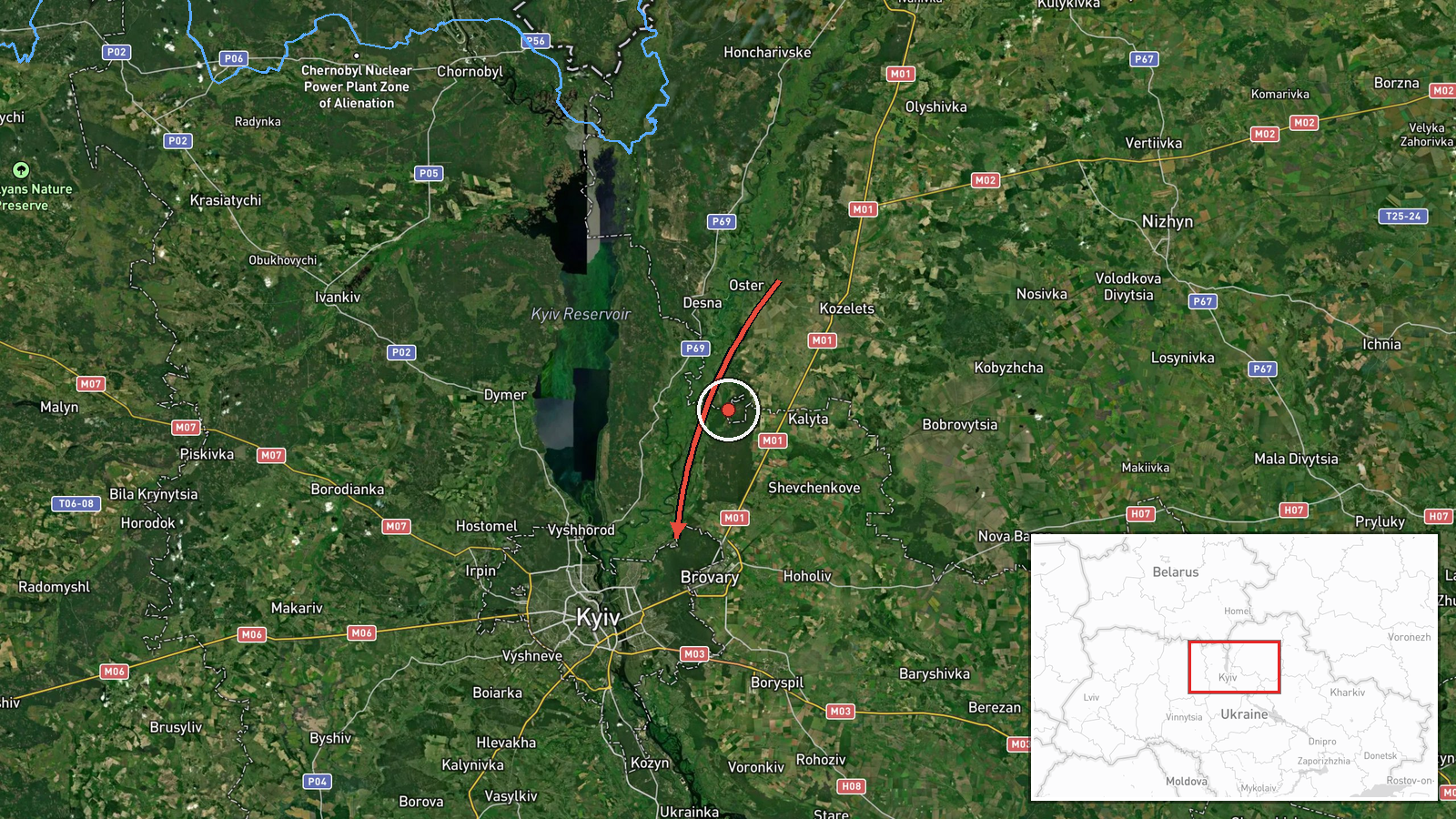
Ukrainian air monitoring channel @kpszsu reported at 07:23 UTC on 19 October 2026 a single jet-powered Shahed-type drone, which the post identifies as a Geran-3, moving through Chernihiv Oblast in the direction of the settlement of Desna, with the post labeling the destination area as Kyiv region. The original Ukrainian wording describes a reactive UAV heading toward Desna, a phrasing that signals a transit track rather than an impact report. The post does not state any damage, casualties, or interception result. The attribution to Russia rests on the monitoring post's identification of the drone type, which is widely used by Russian forces. The report came roughly three hours after a ballistic missile strike on Kyiv earlier that morning.
Context and assessment
Desna lies on the northern approach to the Ukrainian capital, close to the Chernihiv border, so a drone tracked across Chernihiv toward it places the track on a corridor that leads toward Kyiv. The Geran family, derived from the Iranian-designed Shahed-136, has been used in long-range raids on Ukrainian cities and infrastructure since 2022. Jet-powered variants are generally described as faster than propeller-driven models, which can shorten the window for interception and complicate tracking. The drone's appearance follows a night of missile activity over the capital. Monitors logged single ballistic missiles over Kyiv around 19:59 and 20:00 UTC on 18 October, and at 04:20 UTC on 19 October a missile strike reportedly killed a 21-year-old woman and injured three near Chernihivska metro station, with debris damaging a residential building and disrupting the metro. Taken together, the sequence suggests overlapping pressure on the capital from different weapon types. This is an inference from timing, not confirmed intent. A single drone may represent reconnaissance, a diversion, or a straggler from a larger launch. A separate political statement by Zelensky at 05:57 UTC does not bear directly on the tactical picture.
Sources and confidence
The event rests on a single Telegram channel, @kpszsu, which is reportedly linked to Ukrainian air monitoring and publishes real-time air alerts. No second channel or official confirmation appears in the supplied data, so cross-confirmation is absent. The confidence score of 8.0 reflects the channel's established role in air tracking and the specificity of the report, offset by the lack of independent corroboration. Confidence would rise with official Air Force statements, radar-based confirmation, or reports of debris or interception near Desna. It would fall if later updates reclassified the track or showed the drone leaving the area without approaching Kyiv region.
Location
The location is a settlement-level match to Desna, Ukraine, with high confidence, placed at roughly 50.52 N, 30.68 E. The drone was tracked toward Desna rather than over it, so the coordinates mark the stated destination, not a confirmed position of the aircraft. The settlement lies near the Chernihiv border in the Kyiv region, in flat, wooded farmland along the Desna River, a major left-bank tributary of the Dnipro.
Related events nearby
- Russia launched overnight multi-wave ballistic attack: 16 ballistic missiles targeting Kyiv and Kyiv Oblast, p2026-10-19 04:20 UTC · Ballistic Missile · Chernihivska metro station, Kyiv, Ukraine
- Ukrainian air monitoring: 1 Russian ballistic missile over Kyiv.2026-10-18 20:00 UTC · Ballistic Missile · Kyiv, Ukraine
- Ukrainian air monitoring: 1 Russian ballistic missile over Kyiv.2026-10-18 19:59 UTC · Ballistic Missile · Kyiv, Ukraine
- Ukrainian air monitoring: 1 Russian ballistic missile over Kyiv.2026-10-18 19:59 UTC · Ballistic Missile · Kyiv, Ukraine
- Zelensky offers to halt strikes on Russian diesel facilities in exchange for Patriot missiles, and accuses Was2026-10-19 05:57 UTC · Statement · Kyiv, Ukraine
▶ View this event on the live map

Intel Mapper aggregates open-source reports from monitored Telegram and X channels, geolocates them, cross-checks duplicates across sources and assigns a confidence score. Entries are updated as new confirmations arrive. Read how we verify events.