Ukrainian air monitoring reports two Geran-3 drone transits over northern Ukraine on 20 October
What happened
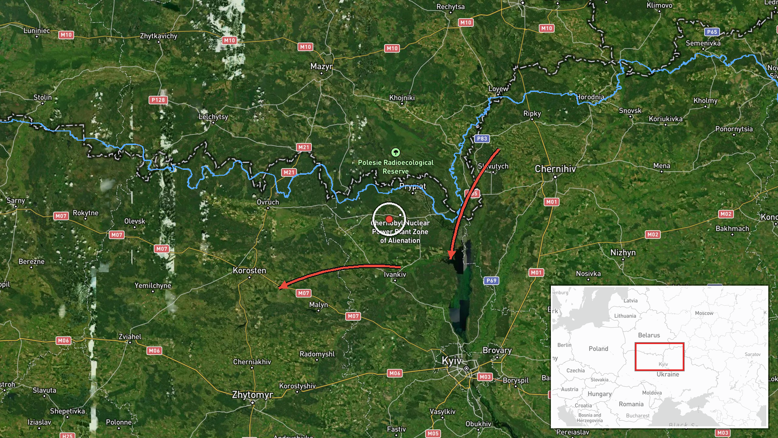
Ukraine's Air Force monitoring channel on Telegram (@kpszsu) reported two separate sightings of single jet-powered Shahed-type drones, identified in the post as Geran-3, with the post timed at 00:45 UTC on 20 October 2026. The first was described as moving from northern Kyiv Oblast toward northern Zhytomyr Oblast; the second from northern Chernihiv Oblast toward northern Kyiv Oblast. The original Ukrainian wording uses the phrase 'Реактивний БпЛА' (jet-powered UAV) and arrow notation to show direction. The post does not mention impacts, damage, casualties, or interceptions. The event is classified as a drone transit, with the location placed in northern Zhytomyr Oblast.
Context and assessment
Northern Zhytomyr Oblast has appeared repeatedly in the reporting over the previous day. Earlier on 19 October, monitoring posts described two or more Geran-3 drones passing through the area heading west, a single drone passing south of Ovruch heading west, and a group of two or more drones heading toward northern Zhytomyr Oblast. Another single drone was reported moving from northern Kyiv Oblast toward the same area at 16:11 that day, and a further sighting placed drones passing Narodychi, also heading west. Taken together, the sequence shows sustained traffic along a northern corridor that runs through the Polissia belt, close to the Belarus border. Transit reports of this kind usually describe the route a drone is observed flying rather than a confirmed target, so they do not by themselves show what the drones were aimed at. The repeated westward and northward headings may indicate that the flights were moving through the region toward other parts of Ukraine, or that the area is being used as a flight path for long-range drones. Reports of this type are best read as evidence of activity along a corridor, not as evidence of strikes in a specific location.
Sources and confidence
The only source for this event is the Telegram channel @kpszsu, which is widely identified as the official channel of Ukraine's Air Force. No second outlet has been found reporting the same sightings, so the event is not independently cross-confirmed. The confidence score of 8.0 reflects the channel's official status and the routine, consistent format of its transit posts, but it is held below maximum because there is a single channel, no imagery, and no independent tracking data in the record. Confidence would rise with corroboration from radar-based tracking, a second official Ukrainian statement, or regional military administration reports. It would fall if the channel later corrected or retracted the post.
Location
The location is recorded at regional precision as northern Zhytomyr Oblast, not at a specific settlement, so the map point is approximate and reflects the centre of the described area rather than a flight position. The region lies in northern Ukraine within the Polissia zone, which is characterised by forests, wetlands, and river valleys, and it borders Belarus to the north. Ovruch and Narodychi, both named in related reports, are towns in the same general area and help define the corridor on the map.
Related events nearby
- Ukrainian air monitoring: 2+ Russian jet-powered Shahed (Geran-3) drones heading toward northern Zhytomyr Obla2026-10-19 18:12 UTC · Drone Transit · northern Zhytomyr Oblast, Ukraine
- Ukrainian air monitoring: 1 Russian jet-powered Shahed (Geran-3) drone from northern Kyiv Oblast toward northe2026-10-19 16:11 UTC · Drone Transit · northern Zhytomyr Oblast, Ukraine
- Ukrainian air monitoring: 2+ Russian jet-powered Shahed (Geran-3) drones passing northern Zhytomyr Oblast, hea2026-10-19 04:40 UTC · Drone Transit · northern Zhytomyr Oblast, Ukraine
- Ukrainian air monitoring: 1 Russian jet-powered Shahed (Geran-3) drone passing south of Ovruch, heading west.2026-10-19 02:50 UTC · Drone Transit · south of Ovruch, Ukraine
- Ukrainian air monitoring: 2+ Russian jet-powered Shahed (Geran-3) drones passing Narodychi, heading west.2026-10-20 00:55 UTC · Drone Transit · Narodychi, Ukraine
▶ View this event on the live map

Intel Mapper aggregates open-source reports from monitored Telegram and X channels, geolocates them, cross-checks duplicates across sources and assigns a confidence score. Entries are updated as new confirmations arrive. Read how we verify events.