Jet-powered Shahed drone reported in Kirovohrad Oblast heading toward Hayvoron
What happened
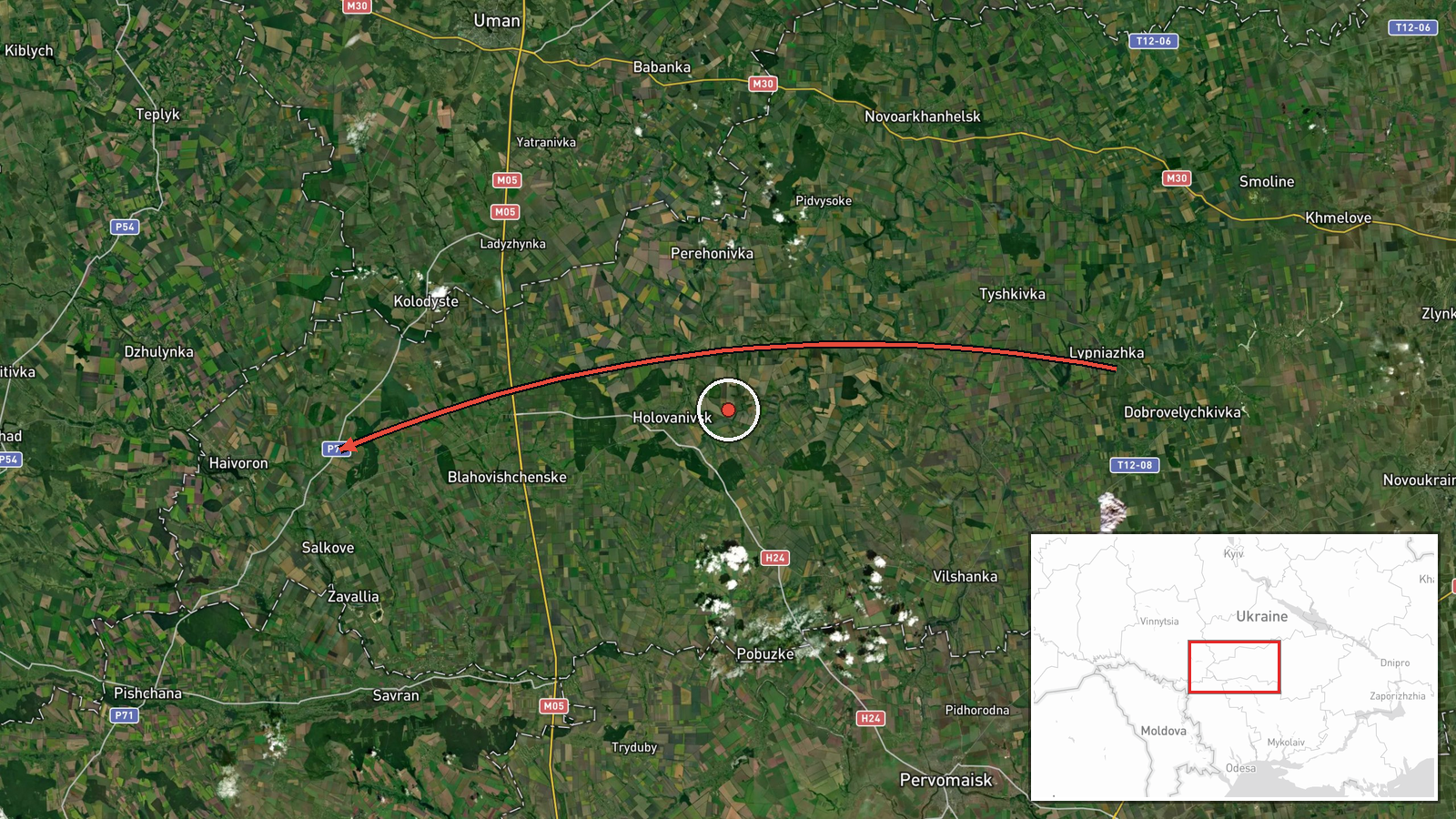
Ukrainian air monitoring, as relayed by the Telegram channel @kpszsu, reported one jet-powered Shahed-type drone, identified as a Geran-3, moving through Kirovohrad Oblast on a course toward Blahovishchenske and Hayvoron. The original Ukrainian-language post was a short alert describing a reactive UAV on that heading. It did not describe any impact, damage or casualties. The alert was timestamped 08:43 UTC on 20 October 2026. The map pins the event at Hayvoron, the settlement named as the endpoint of the course, rather than at a confirmed impact site. Because the report is a transit notice from a single post, the drone's actual path and destination remain unverified.
Context and assessment
Hayvoron's inclusion in this report matters less for the settlement itself than for what the surrounding alerts show about the morning's activity. Between 02:31 and 07:46 UTC, related reports logged a drone from Odesa Oblast toward Rudnytsya, a group of two or more drones from Kirovohrad Oblast toward Bershad, a separate group passing Bershad heading west, another single drone from Kirovohrad toward Bershad at 04:32, and a drone heading toward Ananyiv at 07:46. Taken together, these reports describe sustained, staggered transits of Geran-3 drones across central and southwestern Ukraine, with repeated tracking of traffic originating in Kirovohrad and Odesa oblasts. The reference to Blahovishchenske alongside Hayvoron suggests a northwesterly routing through the region. Transit alerts of this kind are typically issued to warn populations along a projected path. Changing named waypoints may reflect routing adjustments by operators or simply updated tracking, and the data does not identify intended targets. The jet-powered variant is generally faster and harder to intercept than older piston-engine Shaheds, which helps explain why air alerts are issued at such short notice.
Sources and confidence
All information comes from one Telegram channel, @kpszsu, which is widely understood to be the official channel of the Ukrainian Air Force. An official military source gives the report authority, but no independent outlet or second channel in the dataset corroborates it. The confidence score of 8.0 reflects the official origin, the specific drone type, the precise timestamp, and consistency with several related alerts issued the same morning. It is reduced from the maximum because the report is single-source, does not confirm impact, and describes only a transit. Confidence would rise with independent tracking data, later Air Force updates confirming the route, or reports of debris or impact in the area. It would fall if the drone's path were revised, the alert were corrected, or the report could not be matched to later coverage.
Location
The event is pinned at Hayvoron using settlement-level precision, with high location confidence, because the settlement is named directly in the alert and matched to gazetteer coordinates. Hayvoron lies in the north-west of Kirovohrad Oblast, in a predominantly agricultural rural district near the administrative boundaries with neighbouring oblasts. The pin marks the settlement only and does not establish the drone's exact track or any point of impact within it.
Related events nearby
- Ukrainian air monitoring: 1 Russian jet-powered Shahed (Geran-3) drone from Kirovohrad Oblast toward Bershad.2026-10-20 04:32 UTC · Drone Transit · Bershad, Ukraine
- Ukrainian air monitoring: 2+ Russian jet-powered Shahed (Geran-3) drones passing Bershad, heading west.2026-10-20 02:44 UTC · Drone Transit · Bershad, Ukraine
- Ukrainian air monitoring: 2+ Russian jet-powered Shahed (Geran-3) drones from Kirovohrad Oblast toward Bershad2026-10-20 02:32 UTC · Drone Transit · Bershad, Ukraine
- Ukrainian air monitoring: 1 Russian jet-powered Shahed (Geran-3) drone from Odesa Oblast toward Rudnytsya.2026-10-20 02:31 UTC · Drone Transit · Rudnytsya, Ukraine
- Ukrainian air monitoring: 1 Russian jet-powered Shahed (Geran-3) drone heading toward Ananyiv.2026-10-20 07:46 UTC · Drone Transit · Ananyiv, Ukraine
▶ View this event on the live map

Intel Mapper aggregates open-source reports from monitored Telegram and X channels, geolocates them, cross-checks duplicates across sources and assigns a confidence score. Entries are updated as new confirmations arrive. Read how we verify events.