Ukrainian monitoring reports jet-powered Shahed drones passing Lubny toward Kyiv region
What happened
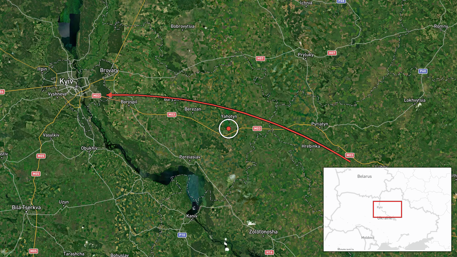
Ukrainian air monitoring, relayed through the Telegram channel @kpszsu, reported at 15:36 UTC on 20 October 2026 that two or more Russian jet-powered Shahed drones, designated Geran-3 in the report, were passing Lubny, a town in Poltava Oblast in central Ukraine, on a course toward Kyiv Oblast. The original post was written in Ukrainian and describes the aircraft as reactive UAVs flying past Lubny toward the Kyiv region. The report names no impact, casualties, or damage and describes only the observed track. Because it comes from a single channel, the count of two or more and the Geran-3 designation rest on that source's wording and have not been independently confirmed in the data set.
Context and assessment
Geran-3 is the jet-powered variant of the Shahed family, generally considered faster and harder to intercept than the piston-engine Geran-2 that dominated earlier waves. Lubny lies well east-southeast of Kyiv, so a track passing it suggests the drones approached from the east or southeast rather than along the western routes often seen in earlier raids. The related events show a sustained pattern on the same day. Between 10:26 and 15:55 UTC, monitoring reported drones over Kyiv Oblast, then over Kyiv city at 12:07, individual drones heading toward Makariv and toward Kyiv, a drone near Dymer at 14:23, and a drone near Boryspil at 15:55. This sequence may indicate a staggered or prolonged approach in several waves rather than a single salvo, with monitoring following individual aircraft across the Kyiv area. Operationally, this could reflect an effort to saturate air defence coverage over several hours. None of the related reports record outcomes, so any inference about intent or effect remains tentative.
Sources and confidence
The only channel listed is Telegram @kpszsu, which is generally treated as an official Ukrainian air-monitoring feed, and that status supports a moderately high baseline score of 8.0. The score is held below the maximum because there is one source and no independent corroboration from regional authorities, news agencies, or flight-tracking data. The related events share the same reporting format and cadence, which supports internal consistency but does not add independent confirmation. Confidence would rise with statements from Poltava or Kyiv regional officials, wire-service pickup, or a matching air-defence report. It would fall if later updates revised the drone count or the designation.
Location
The stored coordinates, 50.45 N and 30.52 E, match the centre of Kyiv city and are a region-level placeholder, not the observed position of the drones. The location was assigned at region precision with low confidence, so the point should not be read as a target or impact site. The reported reference point, Lubny, is a town in Poltava Oblast set among farmland and river valleys in the Dnipro basin, with the Sula River flowing through it. The approach toward Kyiv Oblast crosses open terrain north and east of the capital.
Related events nearby
- Ukrainian air monitoring: 1 Russian jet-powered Shahed (Geran-3) drone passing Boryspil, heading toward Kyiv.2026-10-20 15:55 UTC · Drone Transit · Kyiv, Ukraine
- Ukrainian air monitoring: 1 Russian jet-powered Shahed (Geran-3) drone passing Dymer, heading toward Kyiv.2026-10-20 14:23 UTC · Drone Transit · Kyiv, Ukraine
- Ukrainian air monitoring: 1 Russian jet-powered Shahed (Geran-3) drone heading toward Kyiv.2026-10-20 13:59 UTC · Drone Transit · Kyiv, Ukraine
- Ukrainian air monitoring: 2+ Russian jet-powered Shahed (Geran-3) drones over Kyiv.2026-10-20 12:07 UTC · Drone Transit · Kyiv, Ukraine
- Ukrainian air monitoring: 2+ Russian jet-powered Shahed (Geran-3) drones over Kyiv Oblast; 1 Russian jet-power2026-10-20 10:26 UTC · Drone Transit · Kyiv Oblast, Ukraine
▶ View this event on the live map

Intel Mapper aggregates open-source reports from monitored Telegram and X channels, geolocates them, cross-checks duplicates across sources and assigns a confidence score. Entries are updated as new confirmations arrive. Read how we verify events.