Ukrainian Air Force reports Russian Banderol cruise missiles heading toward Dnipro
What happened
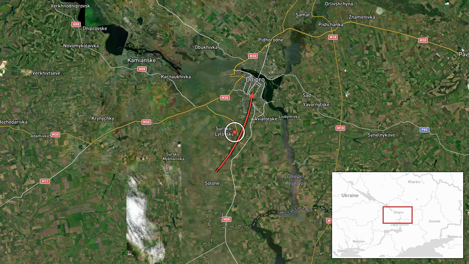
On 21 October 2026 at about 06:08 UTC, the Ukrainian Air Force's Telegram channel, tracked by Intel Mapper, reported that at least two Russian 'Banderol' mini cruise missiles were passing near Solone in Dnipropetrovsk Oblast on a course toward Dnipro. The original Ukrainian post uses the term 'Banderoli' and describes the missiles as passing Solone on a heading to Dnipro. The report does not state the launch point, altitude, or whether the missiles struck a target or were intercepted. It is based on a single channel and has not yet been independently confirmed by other monitors, local officials, or impact reporting.
Context and assessment
Dnipro, a large industrial city on the Dnipro River, has been a recurring target area in the Russia-Ukraine war, and the surrounding oblast has seen repeated air activity. The related events in this feed show a dense sequence over the previous day and a half. On 20 October, drone transits were reported toward Dnipro at 09:36, 13:53 and 16:23 UTC, and a guided glide bomb was reported heading toward the oblast at 17:58. Early on 21 October, a further group of jet-powered Shahed-type drones was tracked passing the oblast heading northwest at 05:59, before the cruise missile report about six minutes later. This layering of drones, glide bombs and now cruise missiles along a similar axis may suggest a coordinated multi-weapon package intended to stretch air defenses or to hit several target sets in quick succession. It may equally reflect separate waves that happen to share a route. Because the feed records warnings and transit paths rather than outcomes, the operational intent cannot be established from this data alone.
Sources and confidence
All information comes from one source, the Telegram channel of the Ukrainian Air Force, which is an official military channel and generally the first to issue air-threat alerts. The confidence score of 8.0 reflects that official origin and the specific weapon labelling, but it is held below the top range because there is no cross-confirmation from a second channel, impact reporting, or local authorities, and no origin data. Confidence would rise with independent tracking from other monitors, local emergency or municipal statements, or reports of impacts or interceptions near the reported track. It would fall if later official updates revised the track, changed the weapon identification, or described the objects as drones or decoys.
Location
The event is placed at settlement-level precision on Dnipro, using the city's central coordinates at roughly 48.46 N, 35.05 E. Solone is named as the reference point on the reported track, but the event coordinates do not mark an exact site or any specific target. Dnipro sits on the Dnipro River in a largely flat steppe landscape of central Ukraine, with the river and its islands running through the urban area. The location should be read as the general destination of the reported track rather than a confirmed impact point.
Related events nearby
- Ukrainian air monitoring: 2+ Russian jet-powered Shahed (Geran-3) drones passing Dnipropetrovsk Oblast, headin2026-10-21 05:59 UTC · Drone Transit · Dnipropetrovsk Oblast, Ukraine
- Ukrainian air monitoring: 1 Russian guided glide bomb (KAB) heading toward Dnipropetrovsk Oblast.2026-10-20 17:58 UTC · Airstrike · Dnipropetrovsk Oblast, Ukraine
- Ukrainian air monitoring: 2+ Russian jet-powered Shahed (Geran-3) drones heading toward Dnipro.2026-10-20 16:23 UTC · Drone Transit · Dnipro, Ukraine
- Ukrainian air monitoring: 1 Russian jet-powered Shahed (Geran-3) drone heading toward Dnipro; 1 Russian jet-po2026-10-20 13:53 UTC · Drone Transit · Dnipro, Ukraine
- Ukrainian air monitoring: jet-powered Russian Shahed-type (Geran-3) drone tracked over Dnipro; shelter warning2026-10-20 09:36 UTC · Drone Transit · Dnipro, Dnipropetrovsk Oblast, Ukraine
▶ View this event on the live map

Intel Mapper aggregates open-source reports from monitored Telegram and X channels, geolocates them, cross-checks duplicates across sources and assigns a confidence score. Entries are updated as new confirmations arrive. Read how we verify events.