Jet-powered Shahed drone reported heading west from northern Kyiv Oblast toward Zhytomyr
What happened
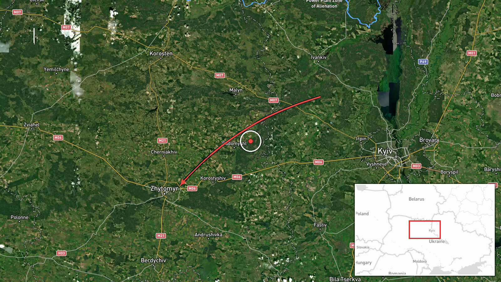
Ukrainian air monitoring reported one jet-powered Russian Shahed-type drone, identified in the report as a Geran-3, moving on a westward course from northern Kyiv Oblast toward Zhytomyr Oblast. The timestamp is 21 October 2026 at 06:37 UTC. The original Ukrainian-language post describes it as a jet-powered UAV and gives no target, impact, or damage information. The report names no specific settlement, and the single-channel source does not say whether the drone was tracked to a destination or lost from monitoring. The event is classed as a drone transit, meaning a flight through airspace rather than a confirmed strike.
Context and assessment
Zhytomyr Oblast lies directly west of Kyiv Oblast and appears repeatedly in the monitoring record provided. Over roughly the preceding 24 hours, related entries show a sequence of single and multi-drone transits: two or more Geran-3 drones from Kyiv Oblast toward Zhytomyr Oblast at 08:13 UTC on 20 October, one passing the Chornobyl Exclusion Zone at 07:29, one passing Zon at 12:16, one heading toward Zhytomyr city at 12:18, and another passing Cherniakhiv heading west at 04:26 on 21 October. The pattern points to a steady stream of drones moving along a north-to-west axis through the oblast rather than an isolated flight. Operationally, transits of this kind are often read as reconnaissance, route testing, or pressure on air defence and on energy or transport assets further west, though the data alone cannot establish intent. The jet-powered Geran-3 variant is faster than the older piston-engined Shahed design, which may shorten the warning window for communities on its track. The consistent wording across entries from one channel also means the picture reflects monitoring coverage as much as true flight density.
Sources and confidence
All reporting traces to one Telegram channel, @kpszsu, which reportedly carries official Ukrainian Air Force alerts. No independent outlet, wire service, or second monitoring feed in the provided data corroborates this specific track, so cross-confirmation is absent. The confidence score of 8.0 reflects a credible official-style source with a clear, time-stamped message, offset by single-source status and the lack of precise location. Confidence would rise with corroboration from a second air-monitoring feed, radar-based reporting, or a later update naming a settlement or outcome. It would fall if the channel issued a correction or if later reporting contradicted the flight path.
Location
The location is recorded at region level only. The coordinates (50.25, 28.66) are an approximate centre point for Zhytomyr Oblast rather than a settlement, so location confidence is rated low and no origin point is pinned. The described route begins in northern Kyiv Oblast, which lies outside the plotted point. The northern parts of Zhytomyr Oblast border the Chornobyl Exclusion Zone and include extensive forest and wetland, while the city of Zhytomyr sits in the central-western part of the oblast.
Related events nearby
- Ukrainian air monitoring: 1 Russian jet-powered Shahed (Geran-3) drone heading toward Zhytomyr.2026-10-21 07:55 UTC · Drone Transit · Zhytomyr, Ukraine
- Ukrainian air monitoring: 1 Russian jet-powered Shahed (Geran-3) drone heading toward Zhytomyr.2026-10-21 07:05 UTC · Drone Transit · Zhytomyr, Ukraine
- Ukrainian air monitoring: 1 Russian jet-powered Shahed (Geran-3) drone heading toward Zhytomyr.2026-10-20 12:18 UTC · Drone Transit · Zhytomyr, Ukraine
- Ukrainian air monitoring: 1 Russian jet-powered Shahed (Geran-3) drone passing Zon, heading toward Zhytomyr Ob2026-10-20 12:16 UTC · Drone Transit · Zhytomyr Oblast, Ukraine
- Ukrainian air monitoring: 2+ Russian jet-powered Shahed (Geran-3) drones from Kyiv Oblast toward Zhytomyr Obla2026-10-20 08:13 UTC · Drone Transit · Zhytomyr Oblast, Ukraine
▶ View this event on the live map

Intel Mapper aggregates open-source reports from monitored Telegram and X channels, geolocates them, cross-checks duplicates across sources and assigns a confidence score. Entries are updated as new confirmations arrive. Read how we verify events.