Ukrainian monitoring reports one Banderol mini cruise missile heading toward Dnipro
What happened
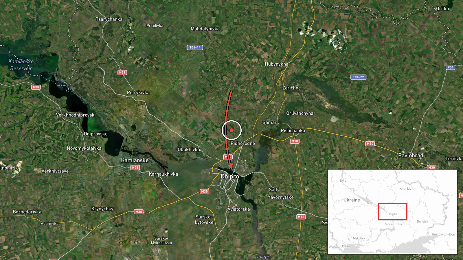
Ukrainian air monitoring posted on the Telegram channel @kpszsu on 21 October 2026 at 10:13 UTC that one Russian Banderol mini cruise missile was moving from the northern part of Dnipropetrovsk Oblast toward the city of Dnipro. The original post uses the phrase баражуючі боєприпаси, which translates as loitering munitions, while the event summary classifies the system as a cruise missile. The report gives no impact point, no damage assessment and no casualty information. The event is logged at settlement precision for Dnipro, with coordinates placed on the city rather than on the missile's track or a launch site. Because this was a real-time air-threat warning from a single channel, it describes what monitors observed in the air, not confirmed results on the ground.
Context and assessment
Dnipro is a large industrial city on the Dnipro River and a long-standing target in Russian strike campaigns, with transport, manufacturing and defense-related sites that have drawn repeated attention. The event fits a pattern visible in the related reports over roughly sixteen hours. On 20 October at 16:23 UTC, 2+ Geran-3 jet-powered drones were reported heading toward Dnipro, and at 17:58 one guided glide bomb was reported heading toward Dnipropetrovsk Oblast. Early on 21 October at 05:59, 2+ Geran-3 drones were reported passing through the oblast heading northwest. At 06:08, 2+ Banderol missiles were reported passing Solone and heading toward Dnipro, and at 10:18 a further 2+ Banderol missiles were reported heading toward the city. The sequence suggests a mixed-type approach in which drones and missiles arrive along overlapping axes over several hours. Operationally, this may indicate an effort to stretch air defenses, to strike a set of targets in the same area, or both. Such an inference rests on the timing and direction of reports rather than on any confirmed target, so it should be treated as provisional.
Sources and confidence
All of the information comes from one channel, the Telegram account @kpszsu, which is widely cited as the public air monitoring feed of Ukraine's Air Force. The related reports come from the same monitoring stream rather than from independent outlets, so they support the pattern but do not verify this specific track. The score of 8.0 reflects a credible official source, a precise time stamp and a location that is consistent with the surrounding reports, offset by the absence of any second channel and the single-source status. Confidence would rise with independent corroboration from regional or city officials, an impact or debris report from Dnipro, or a statement from a second monitoring service. It would fall if later updates revised the weapon type, reported no missile entering the city, or were retracted.
Location
The event is placed at coordinates 48.46 N, 35.05 E, which correspond to the city of Dnipro rather than to a specific facility, so the location is recorded at settlement precision with high location confidence. Dnipro sits on both banks of the Dnipro River, which runs through the city and shapes its approach corridors. The right bank is generally hillier than the left, while the left bank holds much of the flatter urban and industrial area. The northern approach from Dnipropetrovsk Oblast crosses open agricultural land before reaching the city outskirts.
Related events nearby
- Ukrainian air monitoring: 2+ Russian Banderol mini cruise missiles heading toward Dnipro.2026-10-21 10:18 UTC · Cruise Missile · Dnipro, Ukraine
- Ukrainian air monitoring: 2+ Russian Banderol mini cruise missiles passing Solone, heading toward Dnipro.2026-10-21 06:08 UTC · Cruise Missile · Dnipro, Ukraine
- Ukrainian air monitoring: 2+ Russian jet-powered Shahed (Geran-3) drones passing Dnipropetrovsk Oblast, headin2026-10-21 05:59 UTC · Drone Transit · Dnipropetrovsk Oblast, Ukraine
- Ukrainian air monitoring: 1 Russian guided glide bomb (KAB) heading toward Dnipropetrovsk Oblast.2026-10-20 17:58 UTC · Airstrike · Dnipropetrovsk Oblast, Ukraine
- Ukrainian air monitoring: 2+ Russian jet-powered Shahed (Geran-3) drones heading toward Dnipro.2026-10-20 16:23 UTC · Drone Transit · Dnipro, Ukraine
▶ View this event on the live map

Intel Mapper aggregates open-source reports from monitored Telegram and X channels, geolocates them, cross-checks duplicates across sources and assigns a confidence score. Entries are updated as new confirmations arrive. Read how we verify events.