Ukraine's air monitoring reports jet-powered Russian Shahed drones moving from western Dnipropetrovsk
What happened
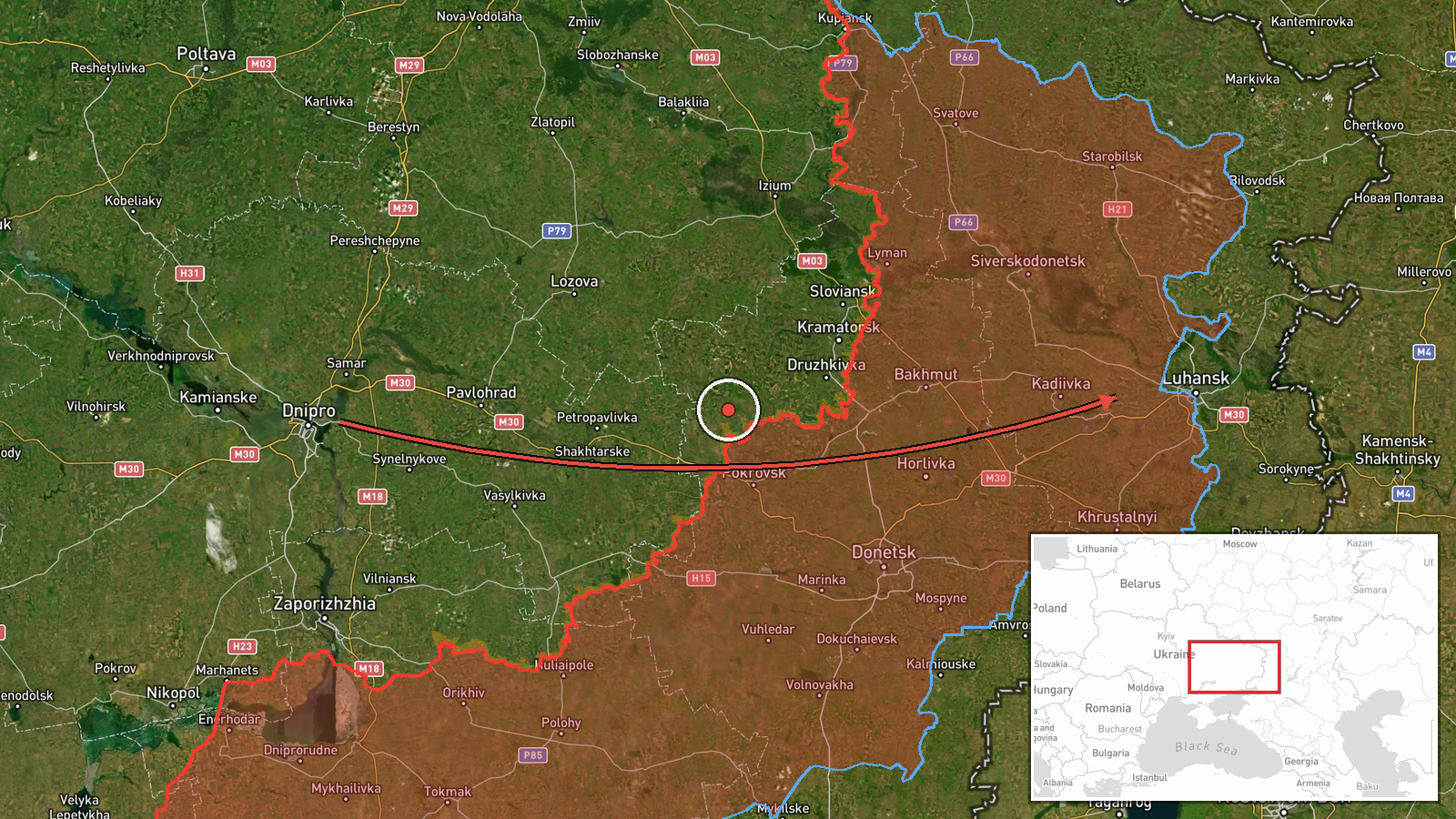
Ukraine's air monitoring channel @kpszsu, which posts Air Force Command updates, reported on 21 October 2026 at 15:42 UTC that two or more jet-powered Russian Shahed-type drones, described as Geran-3, were moving out of western Dnipropetrovsk Oblast. The Ukrainian-language post said the drones were on a course toward Kirovohrad Oblast, and to the east and south. The English summary names Skhidni Kvartaly as the reference point the event is pinned to. The report gave no impact sites, damage, casualties or interception results. Its wording describes a transit track rather than a confirmed strike on Skhidni Kvartaly, so the pinned settlement should be read as a point on that track, not a verified target.
Context and assessment
Western Dnipropetrovsk Oblast lies between the front in the east and the rear provinces of central and western Ukraine. Drones crossing it on a route toward Kirovohrad usually point to routing across central Ukraine rather than a single point strike. Jet-powered Shahed variants are generally assessed as faster than piston-engine models and harder for mobile fire groups to engage, which is why monitoring channels report their transit separately. The same period was dense on the front. A General Staff tally to 22:00 on 20 October, as published in the event data, claimed 229 clashes, 64 airstrikes, 223 glide bombs and 5,881 kamikaze drones across the reporting window. Ukrainian sources also reported a strike on a Russian command post near Kurakhove and repelled assaults near Ozerne, both in Donetsk Oblast. Separately, a communications building in Luhansk was reported burning after an unidentified incident. These reports show a broad, multi-axis tempo without a demonstrated link between them. The transit report most plausibly reflects air-defence probing or a drone package routed toward targets further east or south, but the channel does not say which.
Sources and confidence
The event rests on a single channel, Telegram @kpszsu, the only source listed. No wire service, imagery or second monitoring channel is recorded as confirming the track. The confidence score of 8.0 out of 10 reflects an official military channel and a specific, time-stamped post. It is held below the top range by the single-source status and the lack of impact or interception data. Confidence would rise with corroboration from Air Force statements on interceptions, regional administration reports from Dnipropetrovsk or Kirovohrad, or verified local impact reports. It would fall if later updates change the route or show the track involved a different drone group.
Location
The event is pinned at settlement precision to Skhidni Kvartaly, at coordinates 48.566 latitude and 39.383 longitude, with location confidence rated high. The source describes a flight track across several oblasts rather than a fixed site, so the pin marks a named reference settlement, not a launch site, route point or target. The origin is recorded only as western Dnipropetrovsk Oblast, with no origin coordinates. The surrounding area is largely open steppe and farmland, and no specific nearby features are confirmed by the event data.
Related events nearby
- Communications building, a former Ukrainian Telecom facility in Luhansk, reported burning after an unidentifie2026-10-20 23:42 UTC · Explosion · Luhansk, Luhansk Oblast, Ukraine
- Ukrainian Defense Forces struck a Russian unit command post near Kurakhove, Donetsk Oblast, on October 20-21, 2026-10-21 11:11 UTC · Combat · Kurakhove, Donetsk Oblast, Ukraine
- Ukrainian forces repelled six Russian assault attempts in the Sloviansk direction near Ozerne, Kryva Luka, Ori2026-10-20 19:04 UTC · Combat · Ozerne, Donetsk Oblast, Ukraine
- Ukraine's 2nd Corps Khartiia (National Guard) reportedly infiltrated Russian positions through underground pip2026-10-21 09:04 UTC · Combat · Near Kostyantynivka, Donetsk, Ukraine (front line,
- Ukraine General Staff 24h tally to 22:00 20.10.2026: 229 clashes, 64 airstrikes, 223 glide bombs, 5,881 kamika2026-10-20 19:02 UTC · Report · Donetsk Oblast, Ukraine
▶ View this event on the live map

Intel Mapper aggregates open-source reports from monitored Telegram and X channels, geolocates them, cross-checks duplicates across sources and assigns a confidence score. Entries are updated as new confirmations arrive. Read how we verify events.