Russian Geran-3 drone reported moving from northern Zhytomyr toward northern Rivne Oblast
What happened
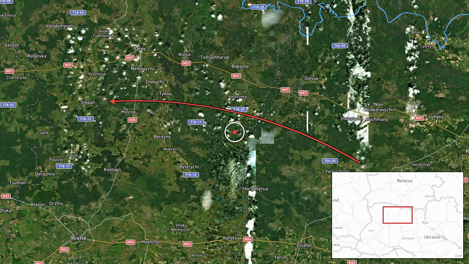
Ukraine's Air Force Telegram channel (@kpszsu) reported one Russian jet-powered Shahed drone, identified as the Geran-3, moving from northern Zhytomyr Oblast toward northern Rivne Oblast at about 09:24 UTC on 23 October 2026. The original Ukrainian post uses the phrase 'Реактивний БпЛА' (jet-type unmanned aerial vehicle) with a route arrow running from northern Zhytomyr to north Rivne, which describes movement rather than a strike. The report mentions no impact, target, or casualties. It is one of a series of similar transit alerts logged across Volyn and Rivne oblasts over roughly the preceding 16 hours, including reports near Sarny, Kostopil, Berezne and Tsuman. The event is recorded as a single-source report, and its geographic placement is approximate, set at regional level rather than at a specific settlement.
Context and assessment
Northern Rivne and Volyn oblasts lie within the Polissia lowlands, a belt of forest, marsh and river valleys close to the Belarus border that carries routes linking western and northern Ukraine. Drones transiting here are usually logged as they pass between observation zones rather than at their final aim point, so this report most likely describes a flight path rather than a particular objective. The related events show a consistent pattern. The same drone type was logged near Sarny on the afternoon of 22 October and again shortly after midnight, then at Sarny, Kostopil, Berezne and Tsuman through the morning of 23 October. The track moves from Volyn toward Rivne and then northward, which may indicate one airframe navigating a broad area or several aircraft following overlapping routes. Because the alerts describe only movement, it is unclear whether the drone was bound for western infrastructure or was being tracked on a rerouting path. Operationally, repeated transits across this northern belt may reflect routing choices that avoid concentrated air defence, but that remains an inference the reports do not establish.
Sources and confidence
The report comes from one channel, Telegram @kpszsu, the official account of Ukraine's Air Force. Official military monitoring is generally treated as reliable for track and direction, and the item fits a sequence of similar alerts earlier the same day. Its score of 8.0 reflects that authority and consistency, but no second source had confirmed the track when it was recorded. Confidence would rise with corroboration from regional military administrations, independent radar-based reporting, or debris and engagement reports. It would fall if later updates revised the direction or identified a different drone type.
Location
The coordinates are a regional centroid for northern Rivne Oblast rather than a specific settlement, so location confidence is low. Placement relies on the report's northward movement toward the Rivne region, cross-checked against nearby waypoints at Sarny, Kostopil, Berezne and Tsuman. The terrain is flat Polissia lowland with extensive forest, peat marsh and river systems draining toward the Pripyat basin, and the area lies near the Belarus border.
Related events nearby
- Ukrainian air monitoring: 1 Russian jet-powered Shahed (Geran-3) drone passing Sarny, heading west.2026-10-23 00:54 UTC · Drone Transit · Sarny, Ukraine
- Ukrainian air monitoring: 1 Russian jet-powered Shahed (Geran-3) drone heading toward Sarny.2026-10-22 16:57 UTC · Drone Transit · Sarny, Ukraine
- Ukrainian air monitoring reports a Russian jet-powered Shahed (Geran-3) drone heading toward Kostopil, Rivne O2026-10-23 09:18 UTC · Drone Transit · Kostopil, Rivne Oblast, Ukraine
- Ukrainian air monitoring: 1 Russian jet-powered Shahed (Geran-3) drone from Rivne Oblast toward Berezne.2026-10-23 07:55 UTC · Drone Transit · Berezne, Ukraine
- Ukrainian air monitoring: 1 Russian jet-powered Shahed (Geran-3) drone from Volyn Oblast toward Tsuman.2026-10-23 06:26 UTC · Drone Transit · Tsuman, Ukraine
▶ View this event on the live map

Intel Mapper aggregates open-source reports from monitored Telegram and X channels, geolocates them, cross-checks duplicates across sources and assigns a confidence score. Entries are updated as new confirmations arrive. Read how we verify events.