Russian Shahed drone transits toward Chernihiv Oblast in overnight strike wave
What happened
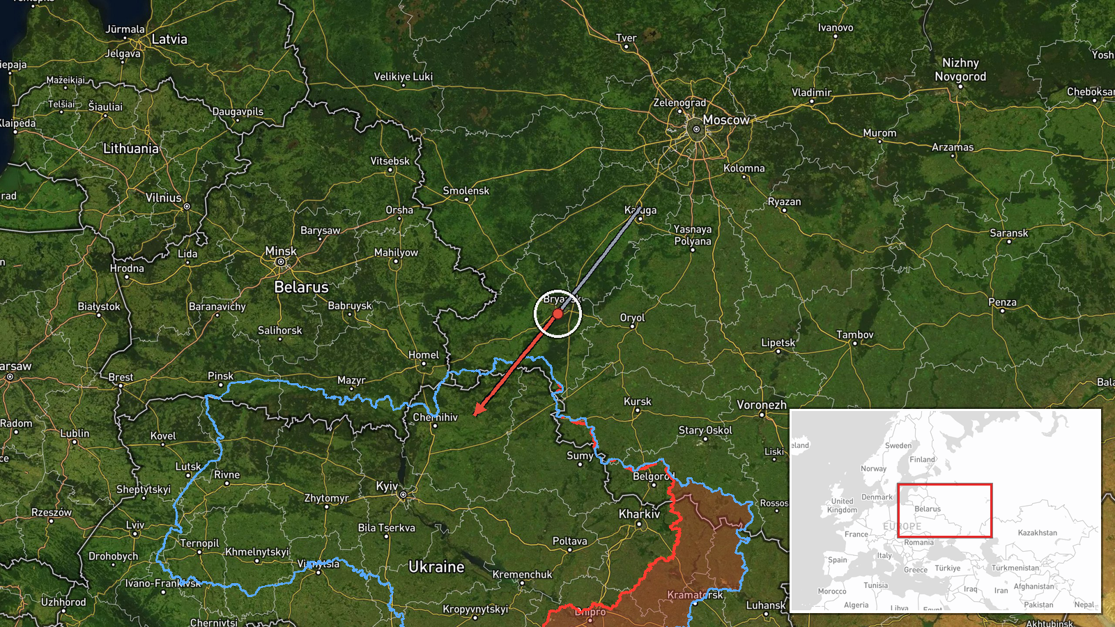
One Russian jet-powered Shahed drone was detected in transit from Bryansk Oblast toward Chernihiv Oblast on the night of 7 September at 20:27 UTC, according to Telegram channel @war_monitor. The detection occurred as part of continuous overnight drone operations across northern Ukraine. The drone's routing suggests potential targeting of assets in the Chernihiv region, though the report does not specify the intended target or outcome.
Context and assessment
Chernihiv Oblast, located in Ukraine's north and bordering Russia and Belarus, remains a recurring axis for Russian drone strikes and reconnaissance missions. This single detection is part of a broader pattern documented on 7 September, with multiple Shahed transits observed over Kyiv, Kyiv, and Cherkasy oblasts the same evening. Shahed drones—jet-powered cruise munitions—typically function as area-denial weapons or strike platforms against civilian and military infrastructure. The concentration of drone activity across a wide front suggests a coordinated overnight offensive, potentially probing air defenses or targeting energy infrastructure ahead of winter operations, a pattern consistent with recent Russian campaign tempo.
Sources and confidence
Reported by single Telegram channel @war_monitor. Confidence score of 6.0 reflects single-source detection without independent cross-confirmation from Ukrainian air defense officials or corroborating channels. Score would rise with statements from Chernihiv military administration or SBU reports; would lower if subsequent reports contradicted the routing or detection.
Location
Detection coordinates place the drone in transit over Chernihiv Oblast, Ukraine's northernmost region bordering Russia. Bryansk Oblast, the reported origin, lies approximately 150–200 km north. The regional-level precision reflects air raid monitoring data; the exact flight corridor and intended impact zone remain unreported.
Related events nearby
- Ukrainian air-raid monitoring reports Russian jet-powered (reaktivnyi) Shahed drones detected transiting over 2026-09-07 21:19 UTC · Drone Transit · Chernihiv Oblast, Ukraine
- Ukrainian air-raid monitoring detected 4 groups of Russian cruise missiles transiting the Sumy-Chernihiv borde2026-09-08 01:35 UTC · Cruise Missile · Sumy-Chernihiv Border Region, Ukraine
- Russian Shahed-136 kamikaze drones detected transiting Kyiv Oblast. One drone tracked toward Krukivshchyna, on2026-09-08 16:34 UTC · Drone Transit · Kyiv Oblast, Ukraine
- Ukrainian air-raid monitoring detected 3 groups of Russian cruise missiles transiting toward Kyiv Oblast with 2026-09-08 02:04 UTC · Cruise Missile · Kyiv Oblast, Ukraine
- Ukrainian air-raid alert monitoring system reports all-clear signal (threat repeal) for Kyiv region after ball2026-09-07 23:25 UTC · Siren · Kyiv Oblast, Ukraine
▶ View this event on the live map
Intel Mapper aggregates open-source reports from monitored Telegram and X channels, geolocates them, cross-checks duplicates across sources and assigns a confidence score. Entries are updated as new confirmations arrive. Read how we verify events.