Ukraine reports 16 Russian assaults repelled near Kostiantynivka, Donetsk Oblast
What happened
Ukraine's General Staff said in an operational update timed 22:00 on 18 October 2026 that its forces repelled 16 Russian assaults on the Kostiantynivka axis. The attacks were reported both in the area of Kostiantynivka itself and toward the villages of Rozkishne, Mykolaipillia and Novohryhorivka, all in Donetsk Oblast. The update was published on the General Staff's Telegram channel and entered the Intel Mapper feed at 19:03 UTC. The original Ukrainian wording describes the events as assaults (штурми) that were repelled, and the English summary follows that framing. The update gives no Russian casualty figures, no unit identities, no timeframe for the 16 attacks, and no account of damage to Ukrainian positions. Those details are absent from the record and should not be inferred.
Context and assessment
Kostiantynivka sits on the northwestern approach to the Donetsk industrial belt, where the road and rail links that connect Donetsk city with the Bakhmut and Druzhkivka areas converge. Control of such urban nodes has shaped the fighting in this part of the front for much of the past two years, and sustained pressure on the town is generally read as an effort to fix Ukrainian reserves and open routes further west. Several related reports from the same day suggest a broad, multi-axis tempo rather than a single push. Air monitoring logged a guided glide bomb heading toward Donetsk Oblast at 06:28 and another toward Kramatorsk at 07:00, while a cruise missile was tracked toward Pivdennyi. Later, Russian forces were reported to have launched 22 assaults on the Pokrovsk axis near Matiashove, Molodetske, Toretsk and Dobropillia. Ukrainian forces also reported repelling attempts on Dobropillia, including infiltration attempts, and Commander-in-Chief Drapatyi was reported to describe the situation as difficult. Taken together, the glide bomb activity may indicate standoff fire support for ground assaults, while the reports of infiltration point to small-group probing alongside larger attacks. These readings are inferences rather than confirmed intent.
Sources and confidence
The event rests on a single Telegram channel, the Ukrainian General Staff, and no independent outlet has yet cross-confirmed the 16-attack count in the data provided. The confidence score of 8.0 reflects an official source with a consistent record of operational updates, offset by the absence of corroboration and the one-sided nature of the claim. Confidence would rise with independent confirmation, such as geolocated footage of the fighting, reporting from regional officials or established conflict monitors, or a matching account from the Russian side. It would fall if the General Staff revises or withdraws the figure, or if geolocated material contradicts the stated locations. The record is marked as not corrected.
Location
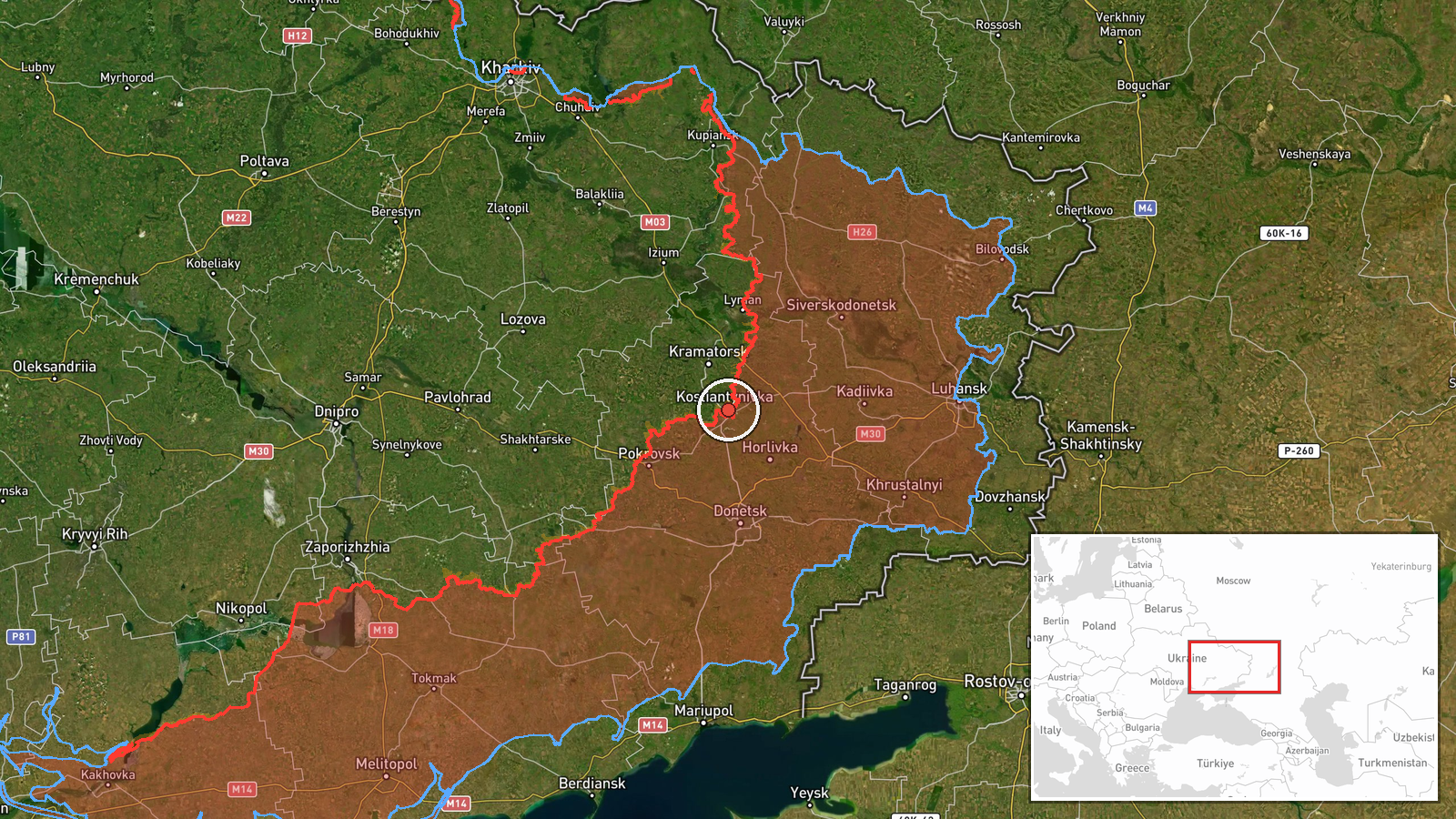
The pin is placed at settlement level on Kostiantynivka, a city in Donetsk Oblast, at approximately 48.533 N, 37.717 E, with normal location confidence. The coordinates reflect the town rather than any specific street or position, and the named villages of Rozkishne, Mykolaipillia and Novohryhorivka are not separately pinned. The setting is an urban and peri-urban area of rolling steppe, with river valleys, rail lines and built-up industrial edges that tend to shape how forces move and where defensive lines form. Nearby reference points include the Pokrovsk axis to the west and Dobropillia to the northwest.
Related events nearby
- Ukrainian air monitoring: 1 Russian Banderol mini cruise missile passing Sharivka, heading toward Pivdennyi.2026-10-18 08:14 UTC · Cruise Missile · Pivdennyi, Ukraine
- Ukrainian air monitoring: 1 Russian guided glide bomb (KAB) heading toward Donetsk Oblast.2026-10-18 06:28 UTC · Airstrike · Donetsk Oblast, Ukraine
- Ukrainian air monitoring: 1 Russian guided glide bomb (KAB) heading toward Kramatorsk.2026-10-18 07:00 UTC · Airstrike · Kramatorsk, Ukraine
- Russian forces launched 22 assault attacks on the Pokrovsk axis near Matiashove, Molodetske and toward Toretsk2026-10-18 19:03 UTC · Combat · Matiashove, Donetsk, Ukraine
- Ukrainian forces report repelling Russian assaults on Dobropillia and destroying infiltration attempts; Comman2026-10-18 14:58 UTC · Combat · Dobropillia, Donetsk Oblast, Ukraine
▶ View this event on the live map

Intel Mapper aggregates open-source reports from monitored Telegram and X channels, geolocates them, cross-checks duplicates across sources and assigns a confidence score. Entries are updated as new confirmations arrive. Read how we verify events.