Ukraine's General Staff reports eight Russian attacks in Kupiansk, three in Lyman and nine in Sloviansk
What happened
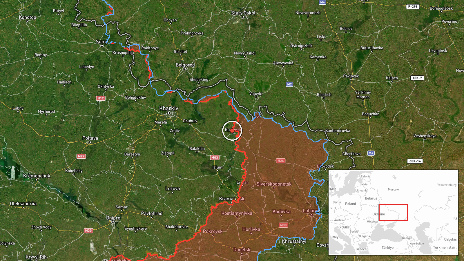
Ukraine's General Staff, posting on its Telegram channel @GeneralStaffZSU, reported on 21 October 2026 at 05:05 UTC that Russian forces carried out offensive actions across three sectors of the front in eastern Ukraine. In the Kupiansk direction, the statement says Russian forces made eight offensive attacks aimed at Radkivka and Mala Shapkivka. The pin for this event is placed on Radkivka, in Kharkiv Oblast. In the Lyman direction, three assaults were reported, including toward Zarichne. In the Sloviansk direction, nine attacks were reported around Ozerne, Kryva Luka, Orikhivka and Yurkivka. The original Ukrainian wording describes these as attempts by the enemy to improve its position. The report gives no outcome figures, casualty numbers or unit details, and the event rests on this single channel.
Context and assessment
The three named axes lie along the northern and eastern edges of the Donetsk and Kharkiv front. Kupiansk has been a contested town since the early months of the full-scale invasion, and Radkivka and Mala Shapkivka sit in its surrounding countryside, so pressure there matters for the wider approach toward the Oskil River corridor. Lyman and Sloviansk are both road and rail hubs whose control would shape movement in the Donetsk region. Related reporting from the previous day points the same way. On 20 October, air monitoring logged a Russian guided glide bomb heading toward eastern Kharkiv Oblast, and Ukrainian sources reported 12 Russian attacks toward ten settlements in the Southern Slobozhansky direction. Another related report, published on 21 October, says Ukrainian units repelled 13 attacks across settlements including Ternova and Starytsia. A separate report from 20 October describes six assault attempts near Ozerne, Kryva Luka, Orikhivka and Yurkivka, which overlaps this event's Sloviansk entries, so the counts may come from different reporting windows. Taken together, the pattern suggests simultaneous probing along several axes, supported by glide bombs and jet-powered Shahed-type drones over Kharkiv. This may indicate an effort to stretch defenders rather than a single breakthrough, though the data does not establish intent.
Sources and confidence
All information comes from one Telegram channel, the Ukrainian General Staff account, which publishes regular front-line summaries. No independent outlet in the dataset repeats these specific attack counts. Related events from air monitoring and other Ukrainian reports are thematically consistent but do not confirm these particular attacks. The confidence score of 8.0 reflects an official, routinely published source with a consistent format, offset by single-channel sourcing and no independent verification of locations or counts. Confidence would rise with independent geolocated footage, statements from local officials, or confirmation from open-source analysts. It would fall if the General Staff revised the figures or if Russian or independent reporting described a markedly different picture.
Location
The event is placed at settlement precision, using coordinates for Radkivka, a village in Kupiansk district of Kharkiv Oblast. The location appears to be an approximate settlement centroid rather than a precise point of contact, and the nearby settlements named in the report are not separately plotted. The surrounding area is largely flat agricultural steppe, cut by river valleys and shelterbelts of trees. The Oskil River, which flows through the Kupiansk area, is the main nearby hydrographic feature.
Related events nearby
- Russian forces made 12 attacks on Ukrainian positions in the Southern Slobozhansky direction toward ten settle2026-10-20 19:03 UTC · Combat · Vovchanski Khutory, Kharkiv Oblast, Ukraine
- Ukrainian units repelled 13 Russian attacks across South Slobozhanshchyna settlements including Ternova, Izbyt2026-10-21 05:04 UTC · Combat · Ternova, Kharkiv Oblast, Ukraine
- Ukrainian forces repelled six Russian assault attempts in the Sloviansk direction near Ozerne, Kryva Luka, Ori2026-10-20 19:04 UTC · Combat · Ozerne, Donetsk Oblast, Ukraine
- Ukrainian air monitoring: 1 Russian jet-powered Shahed (Geran-3) drone over Kharkiv.2026-10-21 02:43 UTC · Drone Transit · Kharkiv, Ukraine
- Ukrainian air monitoring: 1 Russian jet-powered Shahed (Geran-3) drone heading toward Kharkiv.2026-10-21 02:19 UTC · Drone Transit · Kharkiv, Ukraine
▶ View this event on the live map

Intel Mapper aggregates open-source reports from monitored Telegram and X channels, geolocates them, cross-checks duplicates across sources and assigns a confidence score. Entries are updated as new confirmations arrive. Read how we verify events.