RSF claims capture of Al Baraka in Sudan's Blue Nile State; claim unverified
What happened
On 21 October 2026 at 10:32 UTC, the Rapid Support Forces (RSF) reportedly claimed to have liberated Al Baraka, a settlement in Blue Nile State, Sudan. The claim was posted on the RSF-linked Telegram channel @RSFSudan in Arabic and in an English translation. The posts say the force inflicted heavy losses on the Sudanese Armed Forces (SAF) and allied fighters during what it calls the Blue Nile battles. The wording is partisan, describing the opposing side as the 'Muslim Brotherhood Army' and 'mercenaries.' No independent confirmation of control, losses or casualties has been identified in the available reporting. A related RSF statement from the previous evening, 20 October, claimed full control of the Al-Barka area and a military camp, along with seized vehicles and weapons.
Context and assessment
Blue Nile has become an active front in Sudan's wider war, and its towns, dams and river crossings give control of the area strategic weight for both sides. The capture claim sits within a short sequence of related reports. On 20 October, a drone strike near a displacement site in Wad El Mahi reportedly killed at least 31 civilians, mostly women and children; the UN condemned it, but attribution is inferred rather than established. The same day, security operatives reportedly detained three civilians in southern Roseires, adding to rights concerns over tribal-linked detentions in Damazin and Roseires. Taken together, the pattern suggests a contested zone where territorial claims, civilian harm and internal security measures are unfolding at the same time. Operationally, a sequence of statements claiming control of a military camp, followed by a capture claim, may indicate an effort to consolidate ground near the Ethiopian border. That reading remains a hypothesis, since the claims cannot yet be tied to verified battlefield movements.
Sources and confidence
Every report in this cluster traces back to a single channel, Telegram @RSFSudan, which belongs to one of the parties to the conflict. The related RSF statements come from the same source, so they add volume without adding independent confirmation. The confidence score of 3.4 is low, reflecting a single-source claim with no cross-confirmation and an obvious interest in the claim's framing. Confidence would rise if wire agencies, local journalists, UN or humanitarian agencies, or satellite imagery corroborated control of Al Baraka or the reported losses. It would fall further if SAF denied the capture or if imagery showed no change at the site.
Location
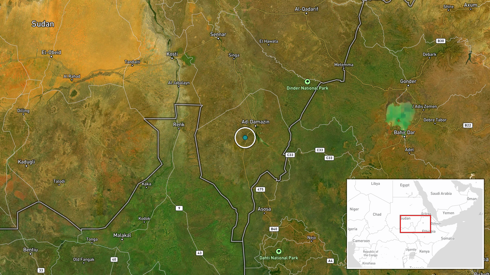
The location is recorded at settlement precision, with coordinates of about 11.5765 N, 34.1525 E and normal location confidence. The name appears in several spellings, including Al-Barka and New Funj, which likely explains some variation across reports. The settlement lies in Blue Nile State in southeastern Sudan, near the Ethiopian frontier. The Blue Nile river and the Roseires Dam area lie within the wider state, which matters for water infrastructure and transport routes.
Related events nearby
- RSF claims it has liberated the strategic Al-Barka area in Blue Nile State. Claim is unverified and comes from2026-10-20 21:20 UTC · Capture · Al-Barka, Blue Nile State, Sudan
- Drone strike near a displacement site in Wad El Mahi, Blue Nile killed at least 31 civilians, mostly women and2026-10-20 14:03 UTC · UAS Strike · Wad El Mahi, Blue Nile State, Sudan
- RSF claims full control of the Al-Barka area and military camp in Blue Nile State, seizing vehicles and weapon2026-10-20 21:20 UTC · Statement · Al-Barka, Blue Nile State (New Funj), Sudan
- Security operatives arrested three civilians in southern Roseires, Blue Nile, amid rising rights concerns over2026-10-20 13:45 UTC · Police Operation · Roseires, Blue Nile State, Sudan
- SAF 4th Mechanized Division repelled an RSF and SPLM-N (al-Hilu) attack on Sali in eastern Blue Nile, capturin2026-10-21 10:40 UTC · Combat · Sali, Blue Nile State, Sudan
▶ View this event on the live map

Intel Mapper aggregates open-source reports from monitored Telegram and X channels, geolocates them, cross-checks duplicates across sources and assigns a confidence score. Entries are updated as new confirmations arrive. Read how we verify events.