Russian Geran-3 drone tracked over Chernihiv Oblast heading toward Ichnia
What happened
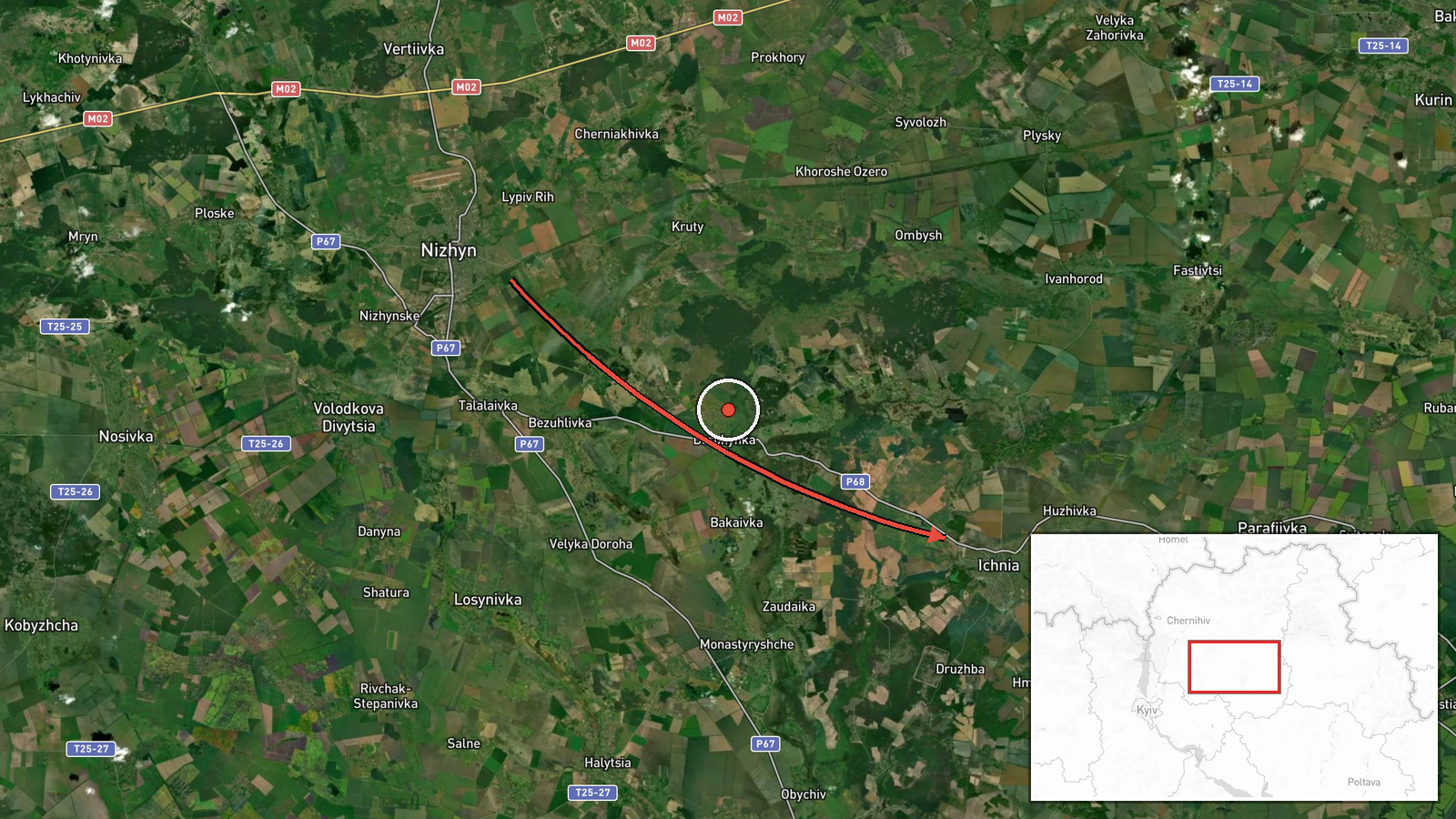
Ukrainian air monitoring detected one Russian jet-powered Shahed (Geran-3) unmanned aerial vehicle transiting near Nizhyn in Chernihiv Oblast on a course toward Ichnia on October 13 at 19:14 UTC. The report was posted by Telegram channel @kpszsu, which monitors Ukrainian air defense activity and drone movements in real time. No interception or strike outcome was specified in the alert.
Context and assessment
Ichnia, located in central Chernihiv Oblast, lies roughly 100 kilometers north of Kyiv and serves as a transport hub connecting the regional interior to major supply routes. The sighting represents part of a sustained pattern of Russian Geran-3 drone activity across northeastern Ukraine on October 13, with parallel detections near Pryluky, Pyryatyn, and Bobrovytsia the same afternoon. Geran-3 variants are capable of carrying larger warheads than earlier Shahed iterations and are typically deployed against rear-area infrastructure, logistics nodes, or civilian targets. The concentration of drone transits across multiple vectors in Chernihiv and neighboring Poltava Oblast may indicate either a coordinated multi-target strike package or a probing operation to test air defense responsiveness.
Sources and confidence
Single source: Telegram channel @kpszsu, which aggregates official Ukrainian air defense alerts and open-source tracking. No cross-confirmation from independent monitors or official Ukrainian military statements is noted in available data. Confidence score of 8.0 reflects the established credibility of @kpszsu as a consistent relay of Ukrainian air monitoring but the absence of corroborating reports or strike confirmation. Independent radar data or additional monitoring channel confirmation would strengthen confidence.
Location
Ichnia, a settlement and district administrative center in Chernihiv Oblast, 50°51'N 32°23'E. Located in central-north Ukraine approximately 90 kilometers northeast of Kyiv city, it sits along the Ichnia River in agricultural terrain. The settlement is a minor transport nexus but lacks major military or strategic installations, suggesting possible targeting of supply infrastructure or civilian area denial.
Related events nearby
- Ukrainian air monitoring: 2+ Russian jet-powered Shahed (Geran-3) drones from Chernihiv Oblast toward Pryluky.2026-10-13 15:58 UTC · Drone Transit · Pryluky, Ukraine
- Ukrainian air monitoring: 1 Russian jet-powered Shahed (Geran-3) drone from Chernihiv Oblast toward Nizhyn.2026-10-13 19:34 UTC · Drone Transit · Nizhyn, Ukraine
- Ukrainian air defense monitoring alerts of active Russian tactical fighter aircraft activity and threat of avi2026-10-13 16:56 UTC · Combat Aircraft · Northeastern Ukraine (Sumy, Chernihiv, Kyiv Oblast
- Ukrainian air monitoring: 1 Russian jet-powered Shahed (Geran-3) drone from Poltava Oblast toward Pyryatyn.2026-10-13 17:07 UTC · Drone Transit · Pyryatyn, Ukraine
- Ukrainian air monitoring: 1 Russian jet-powered Shahed (Geran-3) drone from Poltava Oblast toward Pyryatyn.2026-10-13 13:30 UTC · Drone Transit · Pyryatyn, Ukraine
▶ View this event on the live map

Intel Mapper aggregates open-source reports from monitored Telegram and X channels, geolocates them, cross-checks duplicates across sources and assigns a confidence score. Entries are updated as new confirmations arrive. Read how we verify events.