Russian Shahed drones tracked toward central Ukraine; multiple sorties reported
What happened
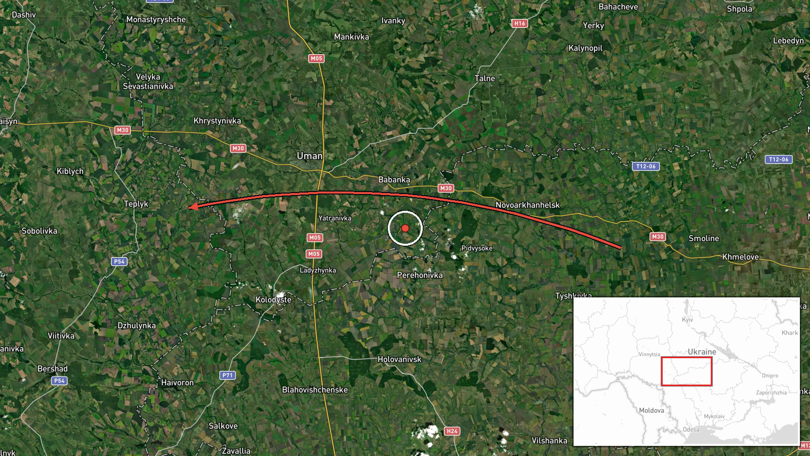
Ukrainian air monitoring detected two or more Russian jet-powered Shahed (Geran-3) drones originating from Kirovohrad Oblast and transiting toward Teplyk in Vinnytsia Oblast on the evening of October 13. The report, issued at 19:48 UTC by the Kyiv Post and Security Service of Ukraine Telegram channel, describes the drones' course and origin but does not specify an outcome. This detection occurred amid a broader pattern of Russian drone operations across central Ukraine that day.
Context and assessment
Teplyk sits in central Vinnytsia Oblast, an area that has seen repeated drone transit activity throughout October 13. Related detections the same day tracked Shahed drones toward Kryzhopil (multiple sorties), Tulchyn, and Chechelnyk—all within or near Vinnytsia and southern Odesa regions. Shahed drones, which carry loitering warheads, are typically used for strikes on infrastructure, military positions, or civilian targets at range. The concentration of sightings across this region suggests a coordinated Russian aerial campaign targeting central Ukrainian territory, though the specific intended targets and any strikes remain unconfirmed from this single source.
Sources and confidence
Reported by the Kyiv Post and Security Service of Ukraine (@kpszsu) on Telegram. Single-source report with high location confidence but no independent cross-confirmation in the provided data. Confidence score of 8.0 reflects established Ukrainian air-monitoring credibility and specific coordinate data. Confirmation by separate monitoring channels or post-strike reports would strengthen assessment; absence of impact claims may indicate interception or mission abort.
Location
Teplyk, a settlement in Vinnytsia Oblast, central Ukraine (48.67°N, 29.74°E). Located in a region of rolling agricultural terrain roughly 250 km southwest of Kyiv. Nearby towns include Gaisin to the south and Tulchyn to the west, both of which reported drone activity the same evening.
Related events nearby
- Ukrainian air monitoring: 1 Russian jet-powered Shahed (Geran-3) drone from Odesa Oblast toward Chechelnyk.2026-10-13 16:59 UTC · Drone Transit · Chechelnyk, Ukraine
- Ukrainian air monitoring: 1 Russian jet-powered Shahed (Geran-3) drone heading toward Tulchyn.2026-10-13 19:37 UTC · Drone Transit · Tulchyn, Ukraine
- Ukrainian air monitoring: 2+ Russian jet-powered Shahed (Geran-3) drones heading toward Kryzhopil.2026-10-13 18:11 UTC · Drone Transit · Kryzhopil, Ukraine
- Ukrainian air monitoring: 1 Russian jet-powered Shahed (Geran-3) drone heading toward Kryzhopil.2026-10-13 17:01 UTC · Drone Transit · Kryzhopil, Ukraine
- Ukrainian air monitoring: 1 Russian jet-powered Shahed (Geran-3) drone heading toward Kryzhopil.2026-10-13 13:29 UTC · Drone Transit · Kryzhopil, Ukraine
▶ View this event on the live map

Intel Mapper aggregates open-source reports from monitored Telegram and X channels, geolocates them, cross-checks duplicates across sources and assigns a confidence score. Entries are updated as new confirmations arrive. Read how we verify events.