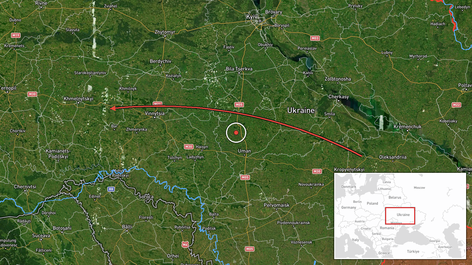
Russian Shahed drone tracked transiting Khmelnytskyi Oblast westward
What happened
Ukrainian air monitoring reportedly detected one Russian Shahed-type drone passing near Pivdennyi in Khmelnytskyi Oblast on 15 October at 16:59 UTC, moving in a westward direction toward the oblast. The report was issued by the Kyiv Post Strategic Communications unit via Telegram. Related observations that day show multiple Shahed transits through the same region, including a variant identified as the jet-powered Geran-3 model, suggesting sustained Russian drone activity across western Ukraine.
Context and assessment
Khmelnytskyi Oblast, located in northwestern Ukraine roughly 350 km from Russian territory, has become a regular corridor for Russian drone strikes targeting infrastructure and civilian areas. The oblast hosts energy facilities and logistics nodes that Russian forces have repeatedly targeted. The pattern of multiple drone sightings on 15 October—spanning from morning through late afternoon—indicates a coordinated or sustained attack effort rather than isolated incidents. Such transits often precede strike impacts by minutes to hours, suggesting Ukrainian air defense may have been under pressure or that multiple waves were being vectored toward the region.
Sources and confidence
Single source: Telegram channel @kpszsu (Kyiv Post Strategic Communications). No cross-confirmation from other open channels provided. Confidence score of 8.0 reflects the source's official status and consistency with related reports on the same day, but single-source reporting and low geographic precision limit certainty. Confirmation by Ukrainian air force or impact reports would strengthen confidence.
Location
Khmelnytskyi Oblast, northwestern Ukraine, approximately 49.4°N, 27.0°E. The report references Pivdennyi (Krasyliv area), a town in the central-western portion of the oblast. The location confidence is marked low, indicating the drone's position was assessed at regional rather than specific settlement level based on available tracking data.
Related events nearby
- Ukrainian air monitoring: 1 Russian jet-powered Shahed (Geran-3) drone heading toward Khmelnytskyi Oblast.2026-10-15 17:30 UTC · Drone Transit · Khmelnytskyi Oblast, Ukraine
- Ukrainian air monitoring: 1 Russian jet-powered Shahed (Geran-3) drone heading toward Khmelnytskyi.2026-10-15 16:04 UTC · Drone Transit · Khmelnytskyi, Ukraine
- Ukrainian air monitoring: 1 Russian jet-powered Shahed (Geran-3) drone heading toward Khmelnytskyi Oblast.2026-10-15 12:27 UTC · Drone Transit · Khmelnytskyi Oblast, Ukraine
- Ukrainian air monitoring: 1 Russian jet-powered Shahed (Geran-3) drone heading toward Khmelnytskyi Oblast.2026-10-15 12:10 UTC · Drone Transit · Khmelnytskyi Oblast, Ukraine
- Ukrainian air monitoring: 1 Russian jet-powered Shahed (Geran-3) drone from Vinnytsia Oblast toward Khmelnytsk2026-10-15 09:49 UTC · Drone Transit · Khmelnytskyi Oblast, Ukraine
▶ View this event on the live map

Intel Mapper aggregates open-source reports from monitored Telegram and X channels, geolocates them, cross-checks duplicates across sources and assigns a confidence score. Entries are updated as new confirmations arrive. Read how we verify events.