Ukrainian monitoring reports 2+ jet-powered Shahed drones moving from Vinnytsia toward Derazhnya
What happened
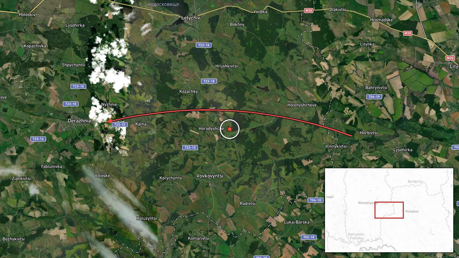
Ukrainian air monitoring posted on Telegram (@kpszsu) on 16 October 2026 at about 10:47 UTC that two or more Russian jet-powered Shahed (Geran-3) drones were moving from Vinnytsia Oblast toward Derazhnya, a settlement in Khmelnytskyi Oblast in western Ukraine. The original post, written in Ukrainian, describes the drones as 'реактивні БпЛА' heading in the direction of Khmelnytskyi Oblast, with Derazhnya named as the reference point. The report describes a drone transit, meaning aircraft passing through or along a route rather than a confirmed strike. No impact, casualties, or damage are stated in the source. The post is a single-channel report and has not been independently confirmed by a second source at the time of recording.
Context and assessment
Derazhnya sits in the Khmelnytskyi region, a area that has repeatedly appeared in Ukrainian air alerts as Russian long-range drones cross western and central Ukraine toward targets farther west. The related events in this set show a steady pattern over the preceding day. Earlier on 15 October, single Geran-3 drones were logged moving through Vinnytsia Oblast toward Letychiv and Bar, and on 16 October a single drone was tracked from Khmelnytskyi Oblast toward Vovkovyntsi. An earlier report that morning described a similar group of jet-powered drones from eastern Khmelnytskyi Oblast toward Derazhnya. The repeated naming of Derazhnya across several reports suggests it lies on a recurring corridor used by drones tracked by Ukrainian monitoring, rather than being an isolated target. Operationally, this pattern may indicate routing toward distant objectives, or it may reflect a drone group being tracked as it moves through the area. The available data does not establish which, and this should be read as a transit pattern rather than evidence of an intended target at Derazhnya itself.
Sources and confidence
The report rests on one Telegram channel, @kpszsu, which is the official channel associated with the Ukrainian Air Force monitoring system. Because it is a single source with no cross-confirmation in the data, the confidence score of 8.0 reflects the official nature of the channel and the specificity of the report, but it is held below the top range because the report is not corroborated. Confidence would rise with confirmation from a second monitoring source, regional military administration statements, or wreckage or impact reports. It would fall if later updates revised the number of drones, the direction, or the location, or if the track was not confirmed by subsequent reporting.
Location
The location is plotted at the settlement level for Derazhnya in Khmelnytskyi Oblast, at approximately 49.269 N, 27.429 E. Coordinates are given as settlement-level precision with high location confidence, since the report names the settlement directly. The area is gently rolling terrain in western Ukraine, with farmland and forest belts and the Khmelnytskyi region's river valleys nearby. The exact point of the drone track is not specified in the report.
Related events nearby
- Ukrainian air monitoring: 2+ Russian jet-powered Shahed (Geran-3) drones from eastern Khmelnytskyi Oblast towa2026-10-16 04:20 UTC · Drone Transit · Derazhnya, Ukraine
- Ukrainian air monitoring: 1 Russian jet-powered Shahed (Geran-3) drone from Vinnytsia Oblast toward Derazhnya.2026-10-15 17:30 UTC · Drone Transit · Derazhnya, Ukraine
- Ukrainian air monitoring: 1 Russian jet-powered Shahed (Geran-3) drone from Khmelnytskyi Oblast toward Vovkovy2026-10-16 01:26 UTC · Drone Transit · Vovkovyntsi, Ukraine
- Ukrainian air monitoring: 1 Russian jet-powered Shahed (Geran-3) drone from Vinnytsia Oblast toward Letychiv.2026-10-15 12:27 UTC · Drone Transit · Letychiv, Ukraine
- Ukrainian air monitoring: 1 Russian jet-powered Shahed (Geran-3) drone heading toward Bar.2026-10-15 15:51 UTC · Drone Transit · Bar, Ukraine
▶ View this event on the live map

Intel Mapper aggregates open-source reports from monitored Telegram and X channels, geolocates them, cross-checks duplicates across sources and assigns a confidence score. Entries are updated as new confirmations arrive. Read how we verify events.