Ukrainian monitors report one jet-powered Shahed drone moving from western Chernihiv toward Oster
What happened
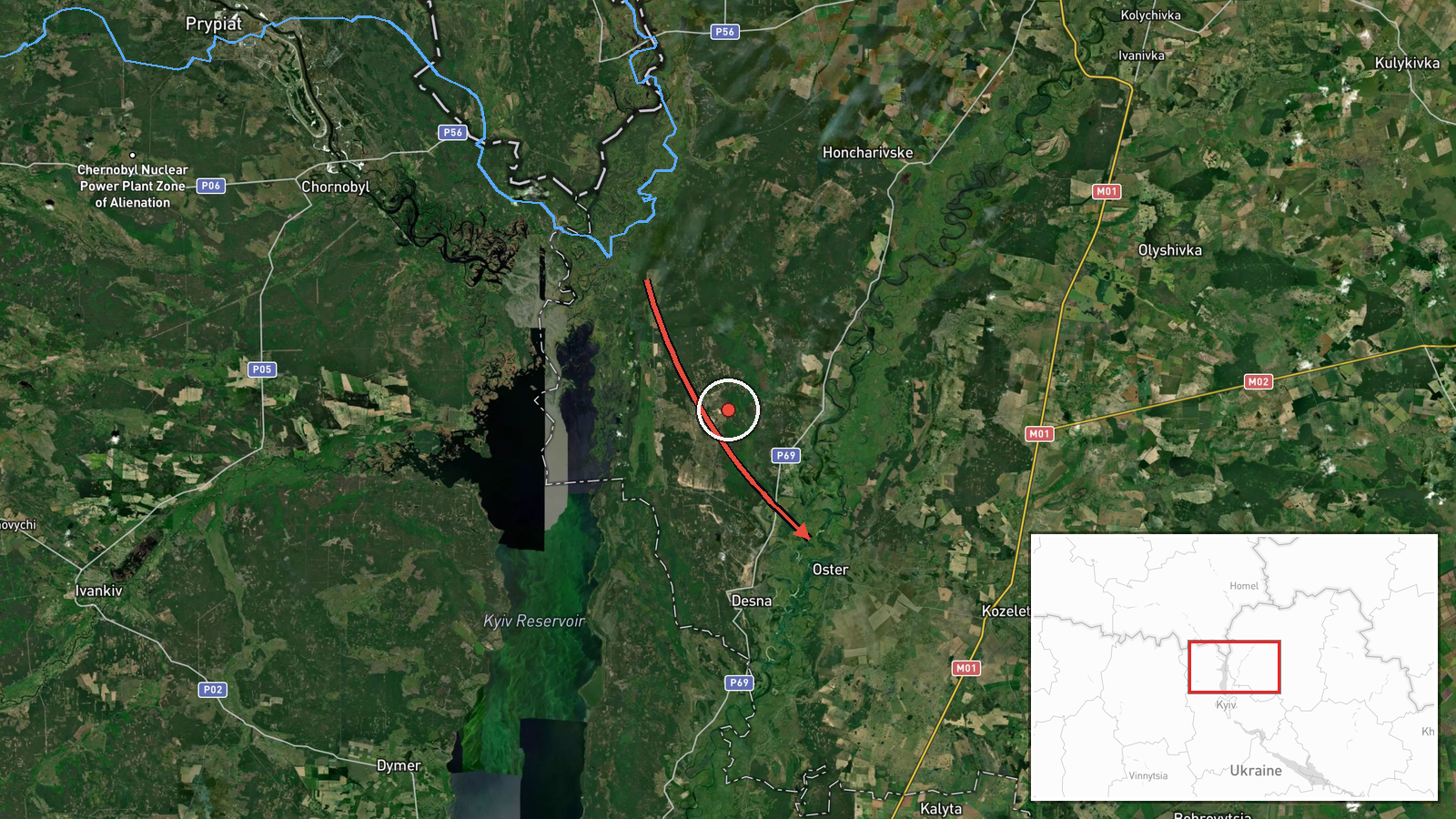
Ukraine's air monitoring channel @kpszsu reported one jet-powered Shahed, designated Geran-3 in the report's wording, moving from western Chernihiv Oblast toward the town of Oster at about 01:23 UTC on 17 October 2026. The original Ukrainian-language post describes a jet-type UAV (реактивний БпЛА) on the western edge of Chernihiv region heading for Oster. The report gives no impact, damage, casualty, or interception outcome, and it does not say whether the drone was later tracked to a different target. Because the message is a short air-alert style notice, its wording reflects a monitoring observation rather than confirmed strike results.
Context and assessment
Oster lies in the northern corridor of Chernihiv Oblast, a route that Russian long-range drones and missiles have repeatedly used to approach Kyiv and its surrounding districts. The event sits within a cluster of related reports. Earlier on 16 October, a Banderol mini cruise missile was reported from southern Chernihiv toward Kozelets at 05:53 UTC. Shortly after, a Geran-3 was reported heading toward Hostomel at 02:43 UTC on 16 October, and another Geran-3 was reported from Chernihiv Oblast toward the Vyshhorod district at 00:28 UTC on 17 October. Taken together, these reports suggest a sustained series of separate approaches across the north of the country within roughly a day, which may indicate route probing, a mixed drone and missile raid, or simply the routine tracking of several inbound aircraft. A separate 16 October report of an energy ceasefire from tg_supernova_plus has no stated parties or body text and cannot be linked to these movements. The pattern supports a cautious reading of continued pressure in the north, but it does not establish intent.
Sources and confidence
The report rests on a single Telegram channel, @kpszsu, which is associated with Ukrainian air monitoring and carries a confidence score of 8.0 with a source count of one. No second outlet, official air force post, or independent observer has been identified for this specific message, and the report carries no imagery or flight-path data. The score reflects the channel's operational role and the specificity of the type and direction, offset by the absence of corroboration. Confidence would rise with a second independent monitor, an official air force confirmation, or track data. It would fall if the channel corrected or withdrew the notice, or if no follow-up appears in later reporting.
Location
The location is recorded at settlement precision, placing the point at the centre of Oster, which is a town on the Desna River in northern Chernihiv Oblast. The location confidence is rated high because the report names the town directly as the drone's heading, not an impact site. The coordinates therefore mark the intended target area rather than a confirmed strike point. The surrounding terrain is low-lying river country with wetlands and floodplain near the Desna, close to the Kyiv Oblast boundary.
Related events nearby
- Ukrainian air monitoring: 1 Russian Banderol mini cruise missile from southern Chernihiv Oblast toward Kozelet2026-10-16 05:53 UTC · Cruise Missile · Kozelets, Ukraine
- Ukrainian air monitoring: 1 Russian jet-powered Shahed (Geran-3) drone from Chernihiv Oblast toward Vyshhorod 2026-10-17 00:28 UTC · Drone Transit · Vyshhorod district, Ukraine
- Ukrainian air monitoring: 1 Russian jet-powered Shahed (Geran-3) drone heading toward Hostomel.2026-10-16 02:43 UTC · Drone Transit · Hostomel, Ukraine
- Report titled 'energy ceasefire' (energy truce) from tg_supernova_plus; no body text or parties specified.2026-10-16 16:02 UTC · Diplomacy · Unknown, Ukraine
- Zelensky says Putin is turning Russia into a war-driven state raising children for war, so Russia will stay da2026-10-16 13:50 UTC · Statement · Kyiv, Ukraine
▶ View this event on the live map

Intel Mapper aggregates open-source reports from monitored Telegram and X channels, geolocates them, cross-checks duplicates across sources and assigns a confidence score. Entries are updated as new confirmations arrive. Read how we verify events.