Multiple Shahed-type drones reported moving toward Kyiv Oblast and central Ukraine, per Ukrainian air monitoring
What happened
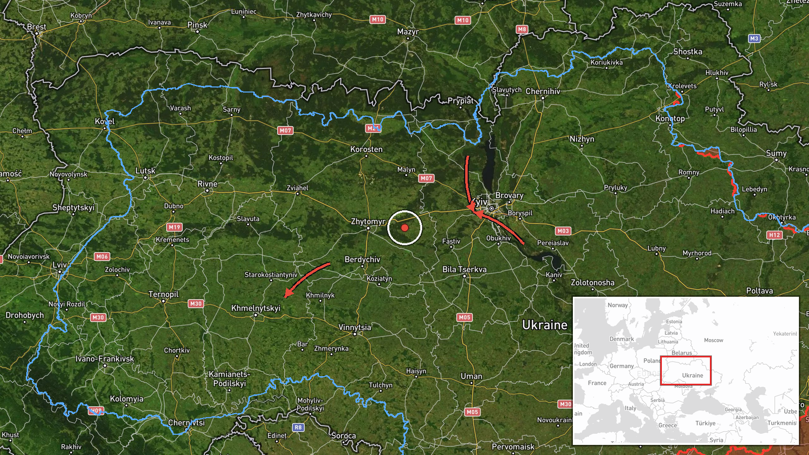
Ukrainian air monitoring, as relayed by the Telegram channel @kpszsu, reported on 17 October 2026 at about 03:59 UTC several Russian Shahed-type drones (BpLA, unmanned aerial vehicles) moving through northern and central Ukraine. The post listed at least three drones entering from western Chernihiv Oblast on a course toward Kyiv Oblast, one passing the Vyshhorod district on a course toward Kyiv, one passing Pereiaslav toward Boryspil or Kyiv, one heading toward Kremenchuk from the east, and one from Zhytomyr Oblast toward Khmelnytskyi Oblast. The report uses the phrase 'курсом на', meaning 'on a course toward', which describes direction of travel rather than confirmed impact points. No strikes, casualties or damage are described in the post.
Context and assessment
Kyiv Oblast has been a recurring focus of drone traffic in the hours before this report. Related entries from the same day show single Shahed-type drones passing Vyshhorod, Drabiv and Slavutych, and one from Cherkasy Oblast heading toward Kyiv Oblast, with at least one identified as a jet-powered Geran-3 variant. Taken together, the pattern suggests a sustained series of routes crossing the northern and central oblasts toward the capital, rather than a single isolated flight. Kyiv and its surroundings host government, energy and transport infrastructure, which makes sustained overflight tracking a standard priority for air defence reporting. The inclusion of Kremenchuk and Khmelnytskyi Oblast indicates that at least some drones were tracked on routes beyond the capital, possibly to draw air defence assets or to test coverage across a wider area. Such an interpretation remains tentative, since the post does not state intent or target, and drone routes can change rapidly or be reported inaccurately during monitoring.
Sources and confidence
The event rests on a single Telegram channel, @kpszsu, which is widely used for Ukrainian air alerts and typically posts in near real time. No second independent outlet appears in the event data to corroborate the individual drone sightings. The confidence score of 8.0 reflects the channel's established role in air monitoring and the specificity of the reported routes, but it is held below the maximum because there is no cross-confirmation and the post describes direction rather than verified positions. Confidence would rise with independent reports from regional military administrations, a Ukrainian Air Force statement, or matching impact or interception reports. It would fall if later updates revised the routes or if the drones were identified as a different category of aircraft.
Location
The location is recorded as Kyiv Oblast at the regional level, with coordinates near Kyiv city (50.45 N, 30.52 E) and a low location confidence and region-level precision. The post names several settlements, including Vyshhorod, Pereiaslav and Kremenchuk, but these describe passage points or headings rather than a single incident site. Kyiv Oblast lies in north-central Ukraine, bordering Chernihiv and Zhytomyr oblasts to the north and west, and it surrounds the capital on the Dnipro River basin. Notable nearby features include the Dnipro and its reservoirs, the Boryspil airport area southeast of the city, and the flat, heavily forested terrain common to the region.
Related events nearby
- Ukrainian air monitoring: 1 Russian Shahed-type drone heading toward Kyiv; 1 Russian jet-powered Shahed (Geran2026-10-17 04:07 UTC · Drone Transit · Kyiv, Ukraine
- Ukrainian air monitoring: 1 Russian Shahed-type drone heading toward Kyiv.2026-10-17 01:36 UTC · Drone Transit · Kyiv, Ukraine
- Ukrainian air monitoring: 1 Russian jet-powered Shahed (Geran-3) drone passing Drabiv, heading toward Kyiv Obl2026-10-16 20:18 UTC · Drone Transit · Kyiv Oblast, Ukraine
- Ukrainian air monitoring: 1 Russian Shahed-type drone passing Slavutych, heading toward Kyiv Oblast.2026-10-16 17:03 UTC · Drone Transit · Kyiv Oblast, Ukraine
- Ukrainian air monitoring: 1 Russian jet-powered Shahed (Geran-3) drone passing Vyshhorod, heading toward Kyiv.2026-10-16 14:41 UTC · Drone Transit · Kyiv, Ukraine
▶ View this event on the live map

Intel Mapper aggregates open-source reports from monitored Telegram and X channels, geolocates them, cross-checks duplicates across sources and assigns a confidence score. Entries are updated as new confirmations arrive. Read how we verify events.