Ukrainian air monitoring reports at least two Russian Shahed-type drones moving toward Hlukhiv, Sumy Oblast
What happened
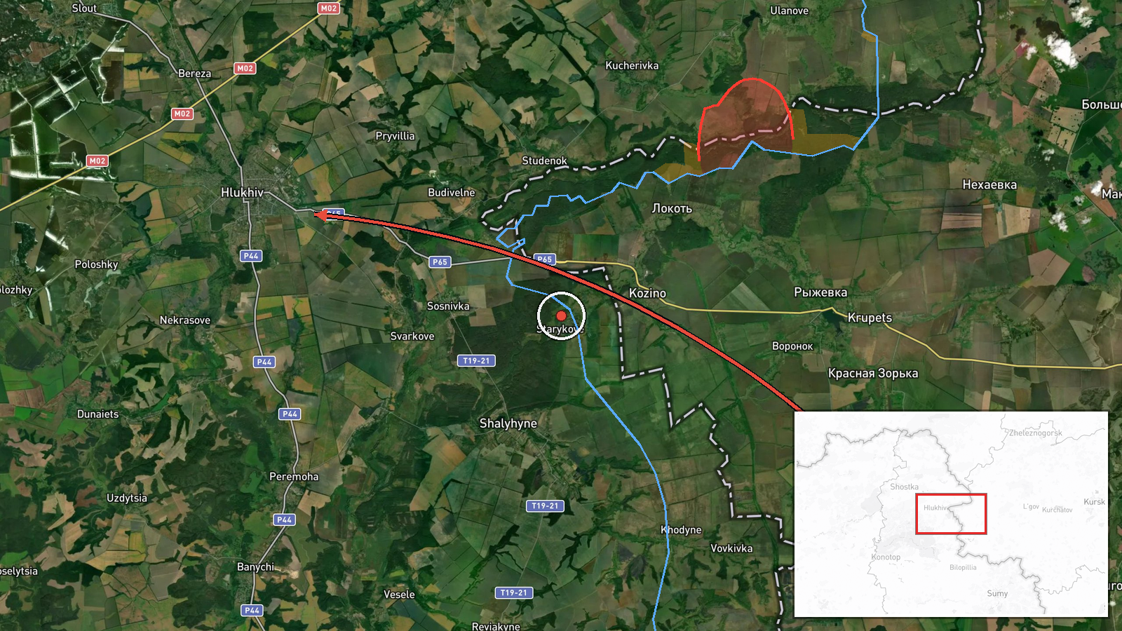
Ukraine's Air Force monitoring channel on Telegram (@kpszsu) reported at 06:46 UTC on 17 October 2026 a group of at least two Russian Shahed-type drones (БпЛА) in northern Sumy Oblast, heading toward Hlukhiv. The original Ukrainian-language post states that the drones were moving toward Hlukhiv from the east, and also toward Voronizh from the east, along the boundary between Chernihiv and Sumy oblasts in a southern direction. The wording describes a transit rather than a strike. The report does not mention impacts, casualties, or damage, and the dataset records it as a single-source report.
Context and assessment
Hlukhiv sits in northern Sumy Oblast close to the Russian border, and drones tracked along the Chernihiv-Sumy boundary fall in a corridor that has seen repeated activity in recent hours. Related entries show a dense overnight and morning pattern in the same area. At 02:21 UTC a single Shahed-type drone was reported heading toward Baturyn, and at 04:26 and 06:50 UTC single drones were reported toward Sumy city. Ground pressure was also present: Ukrainian General Staff reporting cited 11 combat clashes on the North Slobozhansky axis by 22:00 on 16 October, including near Tovstodubove, and artillery shelling of nine Sumy Oblast settlements near Ulanove was reported at 05:05 UTC on 17 October. Operationally, the pattern may indicate reconnaissance, route testing, or attempts to saturate air defenses across several northern towns at once. Because the dataset contains no follow-up on the Hlukhiv group's destination, these readings remain hypotheses rather than established intent.
Sources and confidence
This event rests on one channel, the Telegram account @kpszsu, which is associated with Ukraine's Air Force air-monitoring reporting. Its post was not matched by a second independent source in the dataset, so the score of 8.0 reflects the channel's typical role as an official, time-sensitive alert source rather than multi-source verification. Confidence would rise with corroboration from regional military administrations, other Ukrainian monitoring channels, or subsequent reports of the drones' path or impact. It would fall if later updates contradicted the trajectory, if the track proved to be a different drone group, or if no follow-up appeared.
Location
The location is set to Hlukhiv at settlement precision, with high location confidence, because the post names the city directly. The voiceover also mentions Voronizh, which is not geolocated here. Hlukhiv lies in northern Sumy Oblast near the Russian frontier and the Chernihiv boundary. The surrounding terrain is largely flat agricultural land cut by river valleys and forest belts, which shapes low-altitude drone routes.
Related events nearby
- Russian artillery shelled nine Sumy Oblast settlements, per Ukrainian General Staff; a Russian aviation strike2026-10-17 05:05 UTC · Artillery · Ulanove, Sumy Oblast, Ukraine
- Ukrainian General Staff reports 11 combat clashes on the North Slobozhansky axis by 22:00, including near Tovs2026-10-16 19:01 UTC · Combat · Tovstodubove, Sumy Oblast, Ukraine
- Ukrainian air monitoring: 1 Russian Shahed-type drone heading toward Baturyn.2026-10-17 02:21 UTC · Drone Transit · Baturyn, Ukraine
- Ukrainian air monitoring: 1 Russian Shahed-type drone heading toward Sumy.2026-10-17 06:50 UTC · Drone Transit · Sumy, Ukraine
- Ukrainian air monitoring: 1 Russian Shahed-type drone heading toward Sumy.2026-10-17 04:26 UTC · Drone Transit · Sumy, Ukraine
▶ View this event on the live map

Intel Mapper aggregates open-source reports from monitored Telegram and X channels, geolocates them, cross-checks duplicates across sources and assigns a confidence score. Entries are updated as new confirmations arrive. Read how we verify events.