Single jet-powered Shahed-type drone reported heading toward Bohuslav, Cherkasy Oblast
What happened
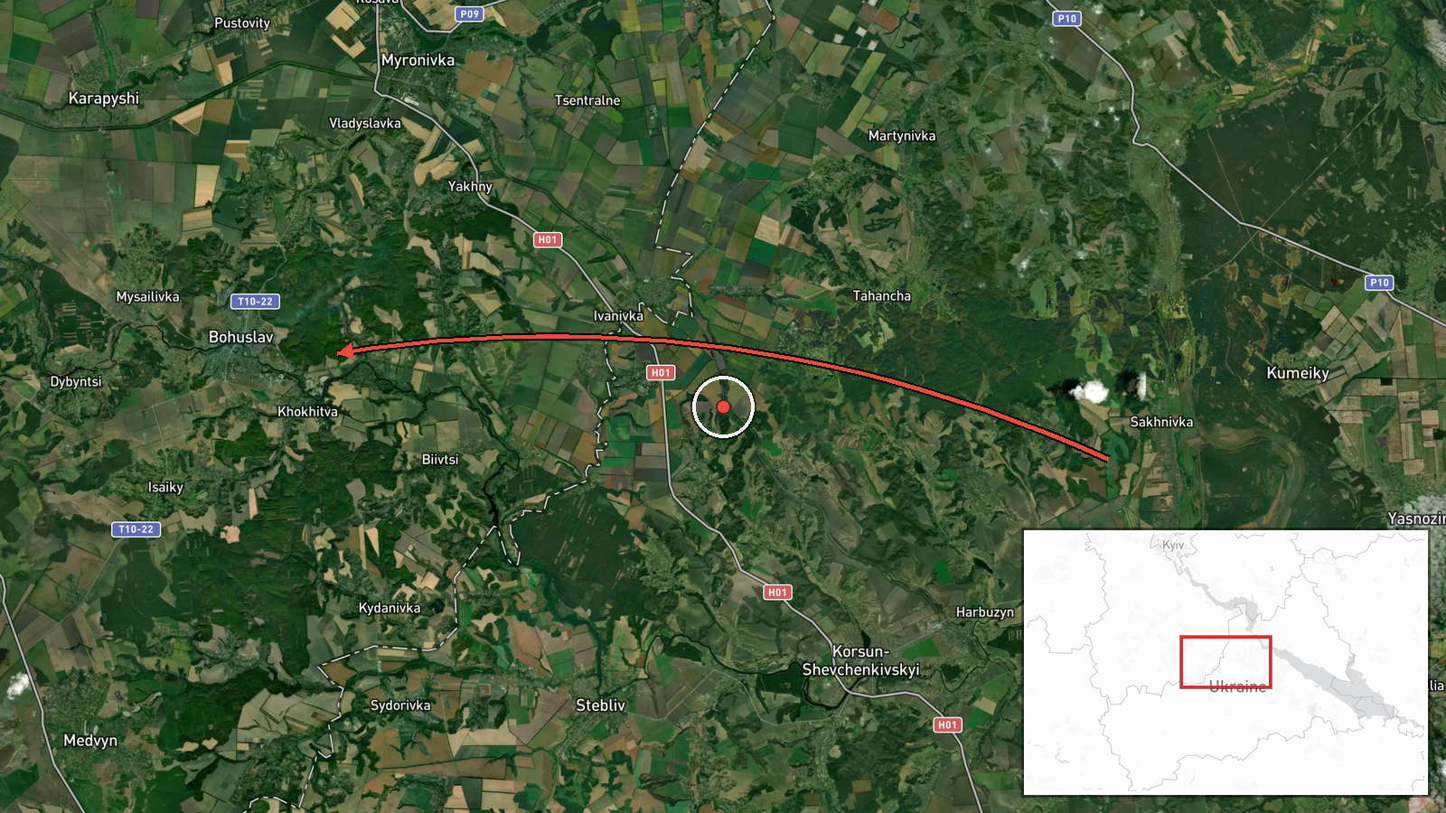
Ukrainian air monitoring reported one Russian jet-powered Shahed-type drone, identified as a Geran-3, moving toward Bohuslav in Cherkasy Oblast on 17 October 2026 at about 12:25 UTC. The original Ukrainian-language message describes a jet-powered UAV heading to Bohuslav in the Cherkasy region from the southeast. The report is a real-time transit warning and does not describe impact, damage, or casualties. It was published by a single Telegram channel, @kpszsu, which relays Ukrainian air-threat monitoring. The post gives no altitude, speed, or confirmed impact point, so the drone's final track and outcome remain unverified.
Context and assessment
Bohuslav sits in a region that Russian long-range drones have repeatedly crossed during this period. In the same 24-hour window, the event page lists several related transit reports in central Ukraine. A Shahed-type drone was reported heading toward Stavyshche at 03:36 UTC on 17 October. At 12:17 UTC, two or more jet-powered Geran-3 drones were reported heading toward Zvenyhorodka, a town about 30 kilometres to the west of Bohuslav. On 16 October a single drone was reported passing Zvenyhorodka heading west, and another Geran-3 was reported heading toward Obukhiv that evening. The Ukrainian General Staff's daily tally to 22:00 on 16 October, as summarised in a related entry, cites 3,857 kamikaze drones and 139 UAVs destroyed. Taken together, the sequence suggests Russian drones were routed through the Cherkasy and Kyiv-adjacent corridors rather than launched at a single aim point. A transit report alone cannot show whether Bohuslav was a target, a waypoint, or simply on a flight path.
Sources and confidence
Only one channel, @kpszsu, carries this report, so there is no independent cross-confirmation at this stage. The confidence score of 8.0 out of 10 reflects a location tagged at high confidence, a clear timestamp, and a specific aerial-type identification, which are typical strengths of official air-monitoring posts. It is not higher because the channel is single-source and the report is an advisory rather than a confirmed event. Confidence would rise if a second Ukrainian official channel, regional military administration, or local news outlet reported the same track, or if later reporting confirmed the drone's destruction or impact. It would fall if subsequent updates revised the drone type, direction, or target area, or if the report was corrected.
Location
The event is placed at the settlement level, using coordinates for Bohuslav at roughly 49.546 N, 30.874 E, which the data marks as high location confidence. The point reflects the town rather than any specific facility, so the drone's exact target or impact site is not identified. Bohuslav lies in Cherkasy Oblast in central Ukraine, in the Dnipro River basin, an area of farmland, small towns, and river valleys. The Dnipro lies to the east, and the broader region connects to major northbound and westbound air corridors used by drones moving toward Kyiv and western Ukraine.
Related events nearby
- Ukrainian General Staff daily tally to 22:00 on 16 Oct: 208 combat clashes, 47 airstrikes, 152 guided bombs, 32026-10-16 19:00 UTC · Report · Ukraine
- Ukrainian air monitoring: 1 Russian Shahed-type drone heading toward Stavyshche.2026-10-17 03:36 UTC · Drone Transit · Stavyshche, Ukraine
- Ukrainian air monitoring: 2+ Russian jet-powered Shahed (Geran-3) drones heading toward Zvenyhorodka.2026-10-17 12:17 UTC · Drone Transit · Zvenyhorodka, Ukraine
- Belgium announces it will supply Ukraine with 10 F-16 fighter jets by the end of the year.2026-10-17 13:09 UTC · Deployment · Ukraine (location not reported)
- Ukrainian air monitoring: 1 Russian jet-powered Shahed (Geran-3) drone heading toward Obukhiv.2026-10-17 12:34 UTC · Drone Transit · Obukhiv, Ukraine
▶ View this event on the live map

Intel Mapper aggregates open-source reports from monitored Telegram and X channels, geolocates them, cross-checks duplicates across sources and assigns a confidence score. Entries are updated as new confirmations arrive. Read how we verify events.