Jet-powered Shahed drone reported moving toward Velyka Dymerka in Kyiv Oblast
What happened
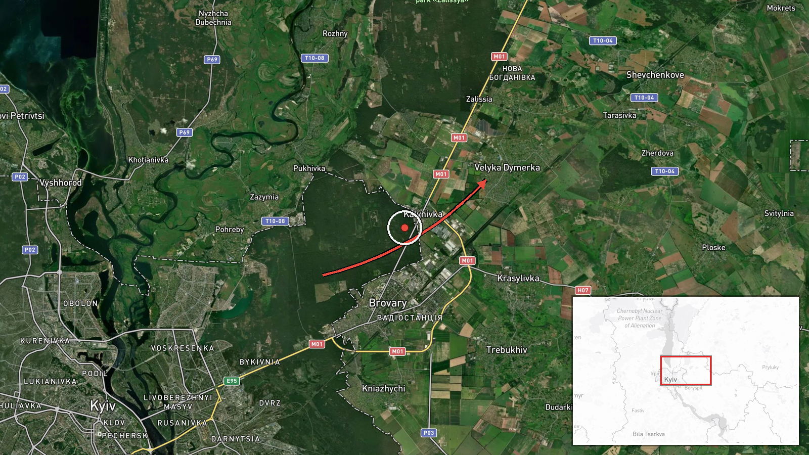
Ukraine's Air Force, reporting through its official Telegram channel @kpszsu, said at 07:31 UTC on 19 October 2026 that one jet-powered drone, identified as a Russian Shahed-type Geran-3, was moving from Kyiv Oblast toward the settlement of Velyka Dymerka. The original post also named Brovary and Kyiv as directions of travel. The Ukrainian wording calls the object a 'reactive UAV' (реактивний БпЛА), a term used in these monitoring messages for jet-powered drones. The report does not describe impacts, casualties, or damage at the settlement, and it gives no altitude, speed, or confirmed landing point. The event is logged as a drone transit rather than a strike.
Context and assessment
This track is one link in a dense sequence over the Kyiv region. At 07:23 UTC a similar jet-powered drone was reported moving from Chernihiv Oblast toward Desna, suggesting a northern approach along the Desna corridor. Earlier, at 04:20 UTC, Russia reportedly launched a multi-wave overnight attack with 16 ballistic missiles and more than 200 drones aimed at Kyiv and Kyiv Oblast. The event summary lists energy sites, a clinic, and a school among the targets, though that list is truncated and cannot be fully verified from the data. On the evening of 18 October, two Banderol mini cruise missiles were tracked toward Vyshhorod, passing Brovary district and the Kyiv Reservoir at 19:40 and 19:41, and a ballistic missile was reported over Kyiv at 20:00. Operationally, the pattern suggests mixed-weapon waves that approach the capital from several directions at once, which can stretch air defense tracking and interceptor allocation. Drones entering from the north may serve as decoys, route-finders, or strike platforms aimed at infrastructure on the eastern and northern approaches. Without impact reports, the purpose of this specific track remains uncertain.
Sources and confidence
The event rests on a single channel, the official Telegram account of the Ukrainian Air Force monitoring service, and the data contains no independent cross-confirmation from other monitoring channels, regional authorities, or media. The confidence score of 8.0 reflects the official origin of the report, its direct attribution wording, and a settlement-level location. It is held below the top range because the claim is single-source and no impact, debris, or follow-up report accompanies it. Confidence would rise with corroboration from other Ukrainian monitoring feeds, regional military administration statements, or flight-track data. It would fall if the track were revised, merged with another object, or reclassified after the fact.
Location
The coordinates are settlement-level, matching the village of Velyka Dymerka, and the location confidence is rated high. The point was assigned from the place name in the monitoring post, not from a track fix or impact site. Velyka Dymerka is a village in the Brovary area of Kyiv Oblast, east of Kyiv city. The surrounding terrain is largely flat, with the Desna river valley and the Dnipro floodplain lowlands to the north and east. The area includes farmland, scattered settlements, and access roads toward Brovary and the capital.
Related events nearby
- Ukrainian air monitoring: 1 Russian jet-powered Shahed (Geran-3) drone from Chernihiv Oblast toward Desna.2026-10-19 07:23 UTC · Drone Transit · Desna, Ukraine
- Russia launched overnight multi-wave ballistic attack: 16 ballistic missiles targeting Kyiv and Kyiv Oblast, p2026-10-19 04:20 UTC · Ballistic Missile · Chernihivska metro station, Kyiv, Ukraine
- Ukrainian air monitoring: 1 Russian Banderol mini cruise missile passing Kyiv Reservoir, heading toward Vyshho2026-10-18 19:41 UTC · Cruise Missile · Vyshhorod, Ukraine
- Ukrainian air monitoring: 1 Russian Banderol mini cruise missile passing Brovary district, heading toward Vysh2026-10-18 19:40 UTC · Cruise Missile · Vyshhorod, Ukraine
- Ukrainian air monitoring: 1 Russian ballistic missile over Kyiv.2026-10-18 20:00 UTC · Ballistic Missile · Kyiv, Ukraine
▶ View this event on the live map

Intel Mapper aggregates open-source reports from monitored Telegram and X channels, geolocates them, cross-checks duplicates across sources and assigns a confidence score. Entries are updated as new confirmations arrive. Read how we verify events.