Jet-powered Shahed drone reported passing Kozelets in Chernihiv region toward Kyiv Oblast
What happened
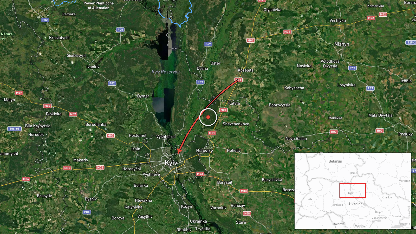
Ukraine's Air Force monitoring channel on Telegram (@kpszsu) reported at 14:01 UTC on 19 October 2026 that a single Russian jet-powered Shahed-type drone, identified in the post as a Geran-3, was passing Kozelets in Chernihiv region and heading toward Kyiv Oblast. The original Ukrainian wording describes a jet-type UAV moving past Kozelets, followed by an arrow pointing to Kyiv region, rather than naming a specific target. The post does not report impacts, damage, or casualties, and it does not say whether the drone was intercepted. Because this is a real-time air alert, the track may have changed after publication. The report sits within a sequence of similar transit alerts logged earlier the same day.
Context and assessment
Kyiv and its surrounding oblast have been a recurring focus of Russian long-range drone and missile activity, and this alert belongs to a clear daytime pattern. Earlier on the same day, a Shahed-type drone and a cruise missile were reported heading toward Kyiv at 03:46 and 03:47, and a Geran-3 was tracked toward the city at 05:27. At 06:47, two or more Geran-3 drones were reported passing Slavutych toward Kyiv Oblast, and at 14:10 another Geran-3 was reported passing Kulykivka on a similar heading. The repeated northern approach through Chernihiv and Kyiv oblasts suggests drones are following a consistent corridor toward the capital. The jet-powered variant is generally faster than propeller-driven Shahed models, which may make it harder for air defense to engage, and that is likely why the alerts specify its type. Operationally, a steady stream of single tracks along multiple points could be used to stretch air defense across several directions or to time larger salvos, but the sequence alone does not establish intent.
Sources and confidence
The event rests on a single channel, the official Ukrainian Air Force monitoring account on Telegram, which is generally treated as a primary source for airspace warnings. The dataset contains no independent cross-confirmation from other outlets, and the related events come from the same type of monitoring feed. The confidence score of 8.0 reflects the official origin of the post and its consistency with earlier alerts that day, tempered by the single-source basis, the real-time nature of the report, and the absence of impact information. Confidence would rise with confirmation from Ukrainian Air Force statements, regional military administrations, or subsequent interception or impact reports. It would fall if the alert were corrected, withdrawn, or contradicted by other tracking data.
Location
The location was assigned from the report's reference to Kozelets, a settlement in northern Chernihiv region. The stored coordinates (50.45, 30.52) and the label Kyiv Oblast reflect a regional centroid rather than the settlement itself, so geographic precision is regional and location confidence is low. The area is part of the flat northern Ukrainian lowlands, with river valleys, forest belts, and farmland, and it lies close to the Belarus border. The terrain offers little natural obstruction to drones moving south toward Kyiv.
Related events nearby
- Ukrainian air monitoring: 1 Russian jet-powered Shahed (Geran-3) drone from Cherkasy Oblast toward Kyiv Oblast2026-10-19 16:07 UTC · Drone Transit · Kyiv Oblast, Ukraine
- Ukrainian air monitoring: 1 Russian jet-powered Shahed (Geran-3) drone heading toward Kyiv.2026-10-19 15:33 UTC · Drone Transit · Kyiv, Ukraine
- Ukrainian air monitoring: 1 Russian jet-powered Shahed (Geran-3) drone passing Kulykivka, heading toward Kyiv 2026-10-19 14:10 UTC · Drone Transit · Kyiv Oblast, Ukraine
- Ukrainian air monitoring: 2+ Russian jet-powered Shahed (Geran-3) drones passing Slavutych, heading toward Kyi2026-10-19 06:47 UTC · Drone Transit · Kyiv Oblast, Ukraine
- Ukrainian air monitoring: 1 Russian jet-powered Shahed (Geran-3) drone heading toward Kyiv.2026-10-19 05:27 UTC · Drone Transit · Kyiv, Ukraine
▶ View this event on the live map

Intel Mapper aggregates open-source reports from monitored Telegram and X channels, geolocates them, cross-checks duplicates across sources and assigns a confidence score. Entries are updated as new confirmations arrive. Read how we verify events.