Single jet-powered Shahed (Geran-3) drone reported passing Boyarka toward Kyiv
What happened
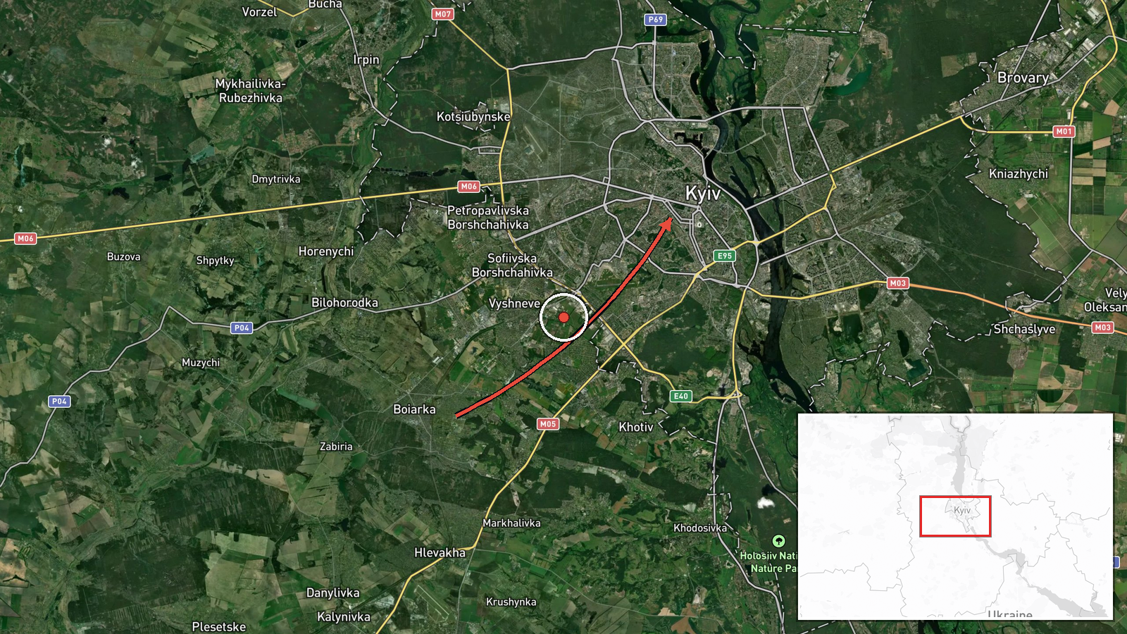
Ukraine's air monitoring reported at 09:58 UTC on 20 October 2026 that one Russian jet-powered Shahed, designated Geran-3, was passing Boyarka on a course toward Kyiv. The original Ukrainian-language post, published on the Telegram channel @kpszsu, reads «реактивний БпЛА повз Боярку курсом на Київ», describing a jet-powered unmanned aerial vehicle moving past Boyarka toward the capital. The message reports no impact, damage, casualties, or interception. Boyarka is a town in Kyiv Oblast on the western edge of the capital, so the event is a transit report on the approach to Kyiv, not a confirmed strike location. It is a monitoring update rather than an account of any detonation.
Context and assessment
Kyiv has been a recurring target of long-range drone traffic, and this entry belongs to a cluster of reports from the same morning. About three and a half hours earlier, a monitoring update logged a single drone heading toward Kyiv at 06:10 UTC, and another at 06:22 UTC described a drone moving from western Chernihiv Oblast toward Kyiv Oblast. At 09:49 UTC, two or more jet-powered Shaheds were reported heading toward the capital. The sequence suggests staggered flights along several approaches rather than a single isolated sortie. A route through Boyarka, which sits on a western axis into the city, would fit that pattern, although a single-channel report cannot establish the drone's intended target. Operationally, jet-powered variants are generally considered faster than the piston-engined Shahed models, which may shorten the time air defense units have to respond. A same-day diplomatic item about planned talks involving Zelensky and US envoy Witkoff, and a Ukrainian General Staff loss tally, form part of the wider news environment but do not establish a link to these flights. The cluster points to an ongoing air threat, not to proof of a specific coordinated operation.
Sources and confidence
The report rests on one source: the Telegram channel @kpszsu, which is quoted here in its Ukrainian original. No wire service, outlet, or second monitoring channel in the available data corroborates this particular transit. The score of 8.0 reflects a channel with a consistent record of air-monitoring posts that match other reports in the same cluster. It is held below the maximum because the post is unconfirmed by any independent source and gives no explicit target or outcome. Confidence would rise if a second air-monitoring source, Kyiv city or Kyiv Oblast officials, or the Air Force itself reported the same track. It would fall if later updates revised the drone count, retracted the track, or placed the object elsewhere.
Location
The location is approximate. The coordinates (50.45, 30.52) are the centre of Kyiv city at settlement precision, while the report names Boyarka, a town in Kyiv Oblast west of the capital. Boyarka's own coordinates were not used. The area is the urbanised western fringe of Kyiv on a largely flat river plain of the Dnipro basin, with the Irpin River and the Dnipro system nearby.
Related events nearby
- Ukrainian air monitoring: 2+ Russian jet-powered Shahed (Geran-3) drones over Kyiv Oblast; 1 Russian jet-power2026-10-20 10:26 UTC · Drone Transit · Kyiv Oblast, Ukraine
- Ukrainian air monitoring: 1 Russian jet-powered Shahed (Geran-3) drone passing Brovary, heading toward Kyiv.2026-10-20 10:17 UTC · Drone Transit · Kyiv, Ukraine
- Ukrainian air monitoring: 2+ Russian jet-powered Shahed (Geran-3) drones heading toward Kyiv.2026-10-20 09:49 UTC · Drone Transit · Kyiv, Ukraine
- Zelensky and US envoy Witkoff to hold talks in Norway today; Witkoff then plans to travel to Putin.2026-10-20 07:46 UTC · Diplomacy · Kyiv, Ukraine
- Ukrainian air monitoring: 1 Russian jet-powered Shahed (Geran-3) drone from western Chernihiv Oblast toward Ky2026-10-20 06:22 UTC · Drone Transit · Kyiv Oblast, Ukraine
▶ View this event on the live map

Intel Mapper aggregates open-source reports from monitored Telegram and X channels, geolocates them, cross-checks duplicates across sources and assigns a confidence score. Entries are updated as new confirmations arrive. Read how we verify events.