Ukrainian Air Force reports one jet-powered Geran-3 drone passing Kulykivka toward Kyiv Oblast
What happened
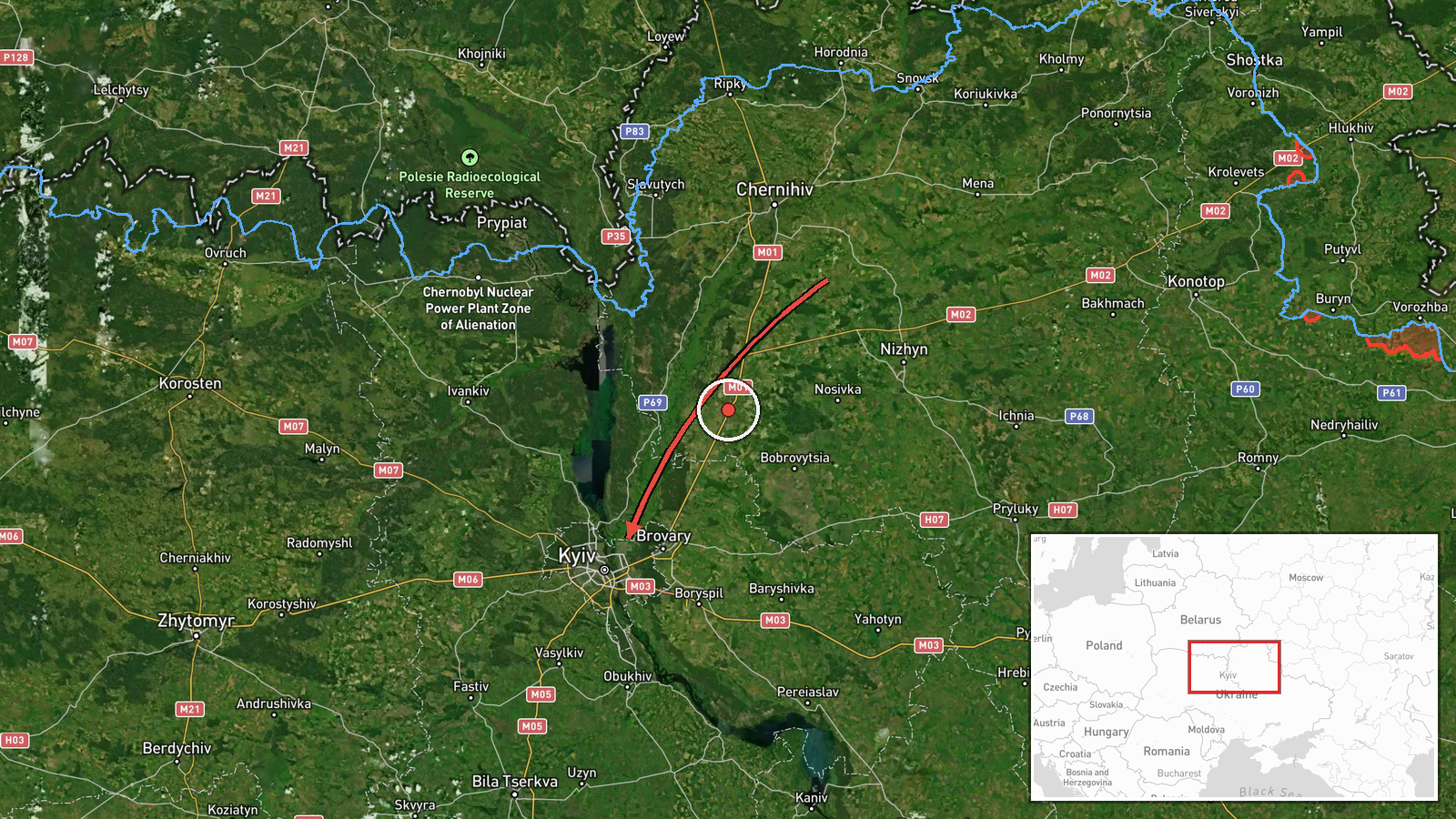
Ukraine's Air Force, via its Telegram channel @kpszsu, reported on 19 October 2026 at 14:10 UTC that a single jet-powered Russian Shahed, identified in the post as a Geran-3, was passing Kulykivka and heading toward Kyiv Oblast. The original Ukrainian post places the drone over Chernihivshchyna, the region where Kulykivka is located, while the event's map tag assigns the incident to Kyiv Oblast at regional precision. The report describes only a transit. It does not mention impacts, damage, casualties or interceptions. The alert is one of several air-monitoring updates issued that day about drones and missiles moving toward the Kyiv area.
Context and assessment
Kyiv has been the focus of repeated air alerts in this sequence. Earlier updates on the same day describe a Shahed-type drone and a cruise missile heading toward the city at 03:46 and 03:47 UTC, a Geran-3 at 05:27 UTC, two or more Geran-3 drones passing Slavutych at 06:47 UTC, and a Geran-3 passing Kozelets at 14:01 UTC. The pattern is a series of staggered tracks that converge on the capital's approaches from the north. Kulykivka's position on that northern approach fits this flight path, although the exact route is not confirmed by the data. Operationally, the reports may suggest that Russian forces are launching drones in successive waves, with some tracks lasting long enough for multiple monitoring posts to report them. Jet-powered Geran-3 variants are generally faster than the original piston-engine Shahed and may be harder to intercept, but the source does not say how this drone's speed or altitude compared with others. Each update should be read as a tracking report of intent, not as confirmed strike planning.
Sources and confidence
The event rests on a single Telegram post from @kpszsu, the channel the Ukrainian Air Force uses for official air-threat alerts. No second outlet, independent monitor or wire service has been found in the supplied data to confirm the sighting. The confidence score of 8.0 reflects a credible official origin and a clear, specific description, offset by the lack of independent confirmation and the regional-only location. Confidence would rise if a second Ukrainian authority, a regional military administration or a monitoring service reported the same track with a named settlement. It would fall if later official corrections changed the drone type, the route or the region.
Location
The geotag is approximate. Coordinates of 50.45 N, 30.52 E sit near Kyiv, while the original text names Kulykivka in Chernihiv region, which lies well north of the capital. The map's location is therefore a regional placeholder rather than a settlement fix. The area between Chernihiv and Kyiv is largely flat, with farmland, forest belts and the Desna and Dnipro river systems, which are commonly used as visual navigation references for low-flying drones.
Related events nearby
- Ukrainian air monitoring: 1 Russian jet-powered Shahed (Geran-3) drone from Cherkasy Oblast toward Kyiv Oblast2026-10-19 16:07 UTC · Drone Transit · Kyiv Oblast, Ukraine
- Ukrainian air monitoring: 1 Russian jet-powered Shahed (Geran-3) drone heading toward Kyiv.2026-10-19 15:33 UTC · Drone Transit · Kyiv, Ukraine
- Ukrainian air monitoring: 1 Russian jet-powered Shahed (Geran-3) drone passing Kozelets, heading toward Kyiv O2026-10-19 14:01 UTC · Drone Transit · Kyiv Oblast, Ukraine
- Ukrainian air monitoring: 2+ Russian jet-powered Shahed (Geran-3) drones passing Slavutych, heading toward Kyi2026-10-19 06:47 UTC · Drone Transit · Kyiv Oblast, Ukraine
- Ukrainian air monitoring: 1 Russian jet-powered Shahed (Geran-3) drone heading toward Kyiv.2026-10-19 05:27 UTC · Drone Transit · Kyiv, Ukraine
▶ View this event on the live map

Intel Mapper aggregates open-source reports from monitored Telegram and X channels, geolocates them, cross-checks duplicates across sources and assigns a confidence score. Entries are updated as new confirmations arrive. Read how we verify events.