Geran-3 jet drone tracked past Drabiv, Cherkasy, toward Kyiv Oblast
What happened
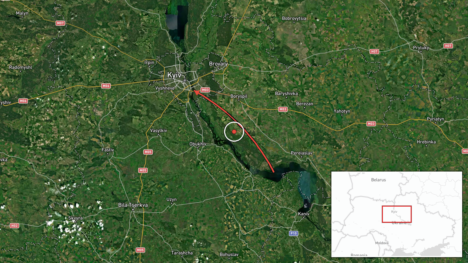
Ukrainian air monitoring posted on Telegram (@kpszsu) on 19 October 2026 at 16:07 UTC that one Russian jet-powered Shahed-type drone, identified as Geran-3, was passing Drabiv in Cherkasy Oblast toward Kyiv Oblast. The post is a brief transit notice and reports no impact, damage, casualties or interception. The original wording, 'another jet-powered UAV' passing Drabiv 'toward the Kyiv region', frames it as a continuing track rather than a strike. The map pin sits at the centre of Kyiv Oblast because no settlement inside that oblast is named, so its position reflects the destination region rather than a confirmed drone location at report time.
Context and assessment
Drabiv sits on the right bank of the Dnipro in the Kaniv area of Cherkasy Oblast, where the river has been widened into a reservoir. The corridor it lies on is a natural route for drones heading north-west toward the capital, because the river valley offers low-altitude cover and a visual reference that is easy to follow. Earlier the same day, the monitoring feed logged a sequence of Geran-3 tracks: two or more drones passing Slavutych at 06:47, then single drones passing Kozelets at 14:01, Kulykivka at 14:10, and heading toward Kyiv at 15:33. Taken together, these reports suggest a sustained wave of jet-powered drones approaching the capital over several hours rather than an isolated flight. The Geran-3 is generally described as faster and harder to intercept than earlier propeller-driven Shahed variants, so repeated tracking along similar axes may indicate attackers probing or saturating air defence routes. Individual transit reports like this one are most useful to air defence and civil warning systems, and they may precede or accompany a larger strike, though the posts alone do not show intent.
Sources and confidence
Only one channel, Telegram @kpszsu, carries this report, and no independent outlet has yet repeated it, so cross-confirmation is absent. The confidence score of 8.0 reflects a single-source, real-time transit notice that is specific about drone type and direction but offers no independent verification of flight path or position. Confidence would rise if Ukrainian Air Force statements, Cherkasy or Kyiv regional military administrations, or open flight-tracking data corroborated the track. It would fall if the drone type or direction were revised, or if the post proved to duplicate an earlier alert.
Location
Coordinates are the approximate centre of Kyiv Oblast, assigned at region-level precision because the source names Drabiv only as a waypoint in Cherkasy Oblast and no Kyiv Oblast settlement. Location confidence is low, so the pin should not be read as the drone's position. Drabiv lies on the Dnipro's right bank near the Kaniv reservoir, while Kyiv Oblast lies to the north and west across the river. The Dnipro and its floodplain are the main nearby features shaping the flight corridor.
Related events nearby
- Ukrainian air monitoring: 1 Russian jet-powered Shahed (Geran-3) drone heading toward Kyiv.2026-10-19 15:33 UTC · Drone Transit · Kyiv, Ukraine
- Ukrainian air monitoring: 1 Russian jet-powered Shahed (Geran-3) drone passing Kulykivka, heading toward Kyiv 2026-10-19 14:10 UTC · Drone Transit · Kyiv Oblast, Ukraine
- Ukrainian air monitoring: 1 Russian jet-powered Shahed (Geran-3) drone passing Kozelets, heading toward Kyiv O2026-10-19 14:01 UTC · Drone Transit · Kyiv Oblast, Ukraine
- Ukrainian air monitoring: 2+ Russian jet-powered Shahed (Geran-3) drones passing Slavutych, heading toward Kyi2026-10-19 06:47 UTC · Drone Transit · Kyiv Oblast, Ukraine
- Ukrainian air monitoring: 1 Russian jet-powered Shahed (Geran-3) drone heading toward Kyiv.2026-10-19 05:27 UTC · Drone Transit · Kyiv, Ukraine
▶ View this event on the live map

Intel Mapper aggregates open-source reports from monitored Telegram and X channels, geolocates them, cross-checks duplicates across sources and assigns a confidence score. Entries are updated as new confirmations arrive. Read how we verify events.