Jet-powered Shahed drones reported passing Olevsk toward Rivne Oblast, Ukraine
What happened
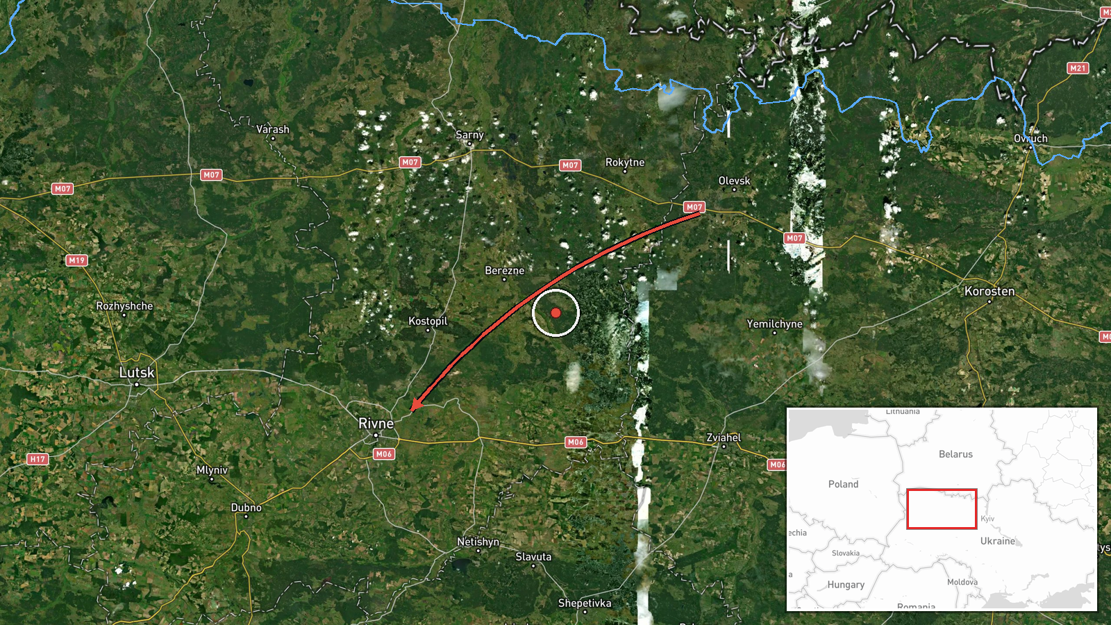
Ukrainian air monitoring reported on 19 October 2026 at 17:35 UTC that two or more Russian jet-powered Shahed (Geran-3) drones were passing the settlement of Olevsk on a course toward Rivne Oblast. The original Ukrainian-language post, carried on the Telegram channel @kpszsu, describes jet-powered UAVs in Zhytomyr region passing near Olevsk and heading toward Rivne region. The notice is a transit alert. It does not describe impacts, damage, casualties, or interceptions. Because it names a heading rather than a confirmed position, it indicates drones over north-western Ukraine moving toward Rivne, not that a strike had occurred. Wording such as 'passing' and 'heading' is used throughout the day's alert series.
Context and assessment
Rivne Oblast sits in north-western Ukraine, close to the Belarusian border, and the city of Rivne is a regional administrative centre and transport hub. Its location makes it a plausible transit corridor for long-range drones routed from the north or east toward western Ukraine, although operator routing cannot be inferred from one alert. The related events from the same day show a sustained sequence: a group of two or more drones heading toward Rivne Oblast at 05:48 UTC, single drones passing Adyn' at 06:39 and 07:31, a drone passing Rivne Oblast heading west at 16:36, and a drone heading toward Rivne city at 17:53. The repeated 'toward Rivne' framing suggests either several separate launches using the same approach or one operation extending over many hours. Jet-powered Geran-3 variants are generally faster and harder to intercept than piston-engined Shahed models, so the alerts may also reflect efforts to track them across a wide area. Operationally, the pattern is consistent with long-duration probing or saturation routing, but the data cannot establish target intent, and transit reports do not confirm where any drone ultimately went.
Sources and confidence
The alert comes from one channel, Telegram @kpszsu, which relays Ukrainian air monitoring messages. Cross-confirmation is limited: the related events share the same channel and wording style, so they are internally consistent but not independently corroborated here. The confidence score of 8.0 reflects the channel's role and the specificity of the alert, tempered by a single source and no imagery or follow-up. Confidence would rise with independent monitoring reports, regional administration statements, or reported debris. It would fall if later updates revised the heading or if detections could not be matched.
Location
The location is recorded at region level, so the coordinates (50.62, 26.25) mark an approximate point in Rivne Oblast near Rivne city, not the drones' actual position. The named settlement, Olevsk, lies in neighbouring Zhytomyr Oblast to the east, so the alert describes a route rather than a site. The area is largely flat to gently rolling, with forest and marshland typical of the Polesia lowlands and river basins such as the Styr and Horyn nearby.
Related events nearby
- Ukrainian air monitoring: 1 Russian jet-powered Shahed (Geran-3) drone heading toward Rivne.2026-10-19 17:53 UTC · Drone Transit · Rivne, Ukraine
- Ukrainian air monitoring: 1 Russian jet-powered Shahed (Geran-3) drone passing Rivne Oblast, heading west.2026-10-19 16:36 UTC · Drone Transit · Rivne Oblast, Ukraine
- Ukrainian air monitoring: 1 Russian jet-powered Shahed (Geran-3) drone passing Adyn’, heading toward Rivne.2026-10-19 07:31 UTC · Drone Transit · Rivne, Ukraine
- Ukrainian air monitoring: 1 Russian jet-powered Shahed (Geran-3) drone passing Adyn’, heading toward Rivne.2026-10-19 06:39 UTC · Drone Transit · Rivne, Ukraine
- Ukrainian air monitoring: 2+ Russian jet-powered Shahed (Geran-3) drones heading toward Rivne Oblast.2026-10-19 05:48 UTC · Drone Transit · Rivne Oblast, Ukraine
▶ View this event on the live map

Intel Mapper aggregates open-source reports from monitored Telegram and X channels, geolocates them, cross-checks duplicates across sources and assigns a confidence score. Entries are updated as new confirmations arrive. Read how we verify events.