Single jet-powered Shahed (Geran-3) drone reported passing Vyshhorod toward Kyiv
What happened
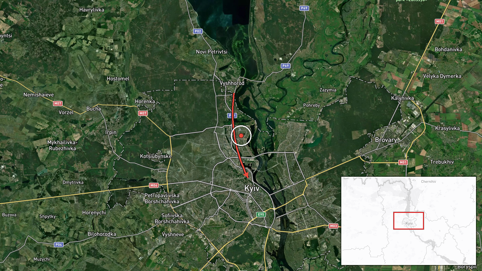
Ukraine's Air Force monitoring feed, posted on Telegram as @kpszsu, reported that one Russian jet-powered Shahed-type drone, identified in the report as a Geran-3, was passing through Vyshhorod, north of Kyiv, on a heading toward the capital. The event is timestamped 19 October 2026 at 23:55 UTC. The original Ukrainian wording describes a jet-powered UAV coming toward Kyiv from the north via Vyshhorod, and the English summary carries the same core claim: one drone, one direction, one destination. The report names no impact point, no damage and no casualties, and it does not say whether the drone was engaged. Because the information is official air-monitoring output rather than field reporting, it describes the aircraft's track, not any outcome on the ground.
Context and assessment
Vyshhorod lies on the Dnipro northwest of Kyiv, and the northern approach has repeatedly been used in Russian long-range drone raids because it brings aircraft over the Kyiv reservoir and the northern districts of the capital. Earlier in the same evening the feed logged a Geran-3 moving from Chernihiv Oblast toward Kyiv Oblast at 23:04, and another jet-powered drone heading toward Kyiv Oblast at 23:36. Taken together, these entries suggest a sequence of single aircraft entering from the north rather than one large salvo, which may indicate probing or sustained pressure, though the data cannot confirm intent. The jet-powered variant is generally described as faster than older propeller-driven Shahed models, which shortens the warning window and can complicate interception. The same period carried a political dimension. Zelensky told US lawmakers that Ukraine received no warning from partners about a recent wave of ballistic missiles, described as the third such failure, and proposed a 30-day halt to strikes on Russian refineries in exchange for Patriot interceptors. These statements connect to the interceptor-supply debate, but the drone report does not itself show a causal link.
Sources and confidence
The report comes from a single channel, Telegram @kpszsu, the official Ukrainian Air Force feed used for air-threat alerts. No other outlet in the event set independently reports this specific track, so cross-confirmation is absent. The confidence score of 8.0 reflects an official originator and a specific, time-stamped track, offset by the single-source basis and the lack of independent radar or witness confirmation. Confidence would rise with corroboration from a second Ukrainian authority, regional military administration statements, or reports of an intercept or impact in the Kyiv area. It would fall if the track were revised, retracted, or shown to involve a different aircraft.
Location
The coordinates place the event at the centre of Kyiv (50.45, 30.52), a settlement-level point rather than the drone's actual position. The report describes an approach from the north via Vyshhorod, a town on the Dnipro roughly 20 km northwest of central Kyiv, so the true track lies outside the plotted point. The surrounding terrain is flat river country, with the Kyiv reservoir and broad floodplains to the north of the city.
Related events nearby
- Ukrainian air monitoring: 1 Russian jet-powered Shahed (Geran-3) drone heading toward Kyiv Oblast.2026-10-19 23:36 UTC · Drone Transit · Kyiv Oblast, Ukraine
- Zelensky tells US lawmakers a political decision is slowing support to Ukraine, in sharp contrast to battlefie2026-10-19 23:21 UTC · Statement · Kyiv, Ukraine
- Zelensky tells US lawmakers Ukraine got no warning from partners about Russian ballistic missile waves, the th2026-10-19 23:20 UTC · Statement · Kyiv, Ukraine
- Ukrainian air monitoring: 1 Russian jet-powered Shahed (Geran-3) drone from Chernihiv Oblast toward Kyiv Oblas2026-10-19 23:04 UTC · Drone Transit · Kyiv Oblast, Ukraine
- Zelensky proposed a 30-day halt to Ukrainian strikes on Russian oil refineries in exchange for U.S. Patriot in2026-10-19 21:57 UTC · Diplomacy · Kyiv, Ukraine
▶ View this event on the live map

Intel Mapper aggregates open-source reports from monitored Telegram and X channels, geolocates them, cross-checks duplicates across sources and assigns a confidence score. Entries are updated as new confirmations arrive. Read how we verify events.