Ukrainian air monitoring reports one jet-powered Shahed drone heading toward Kovel
What happened
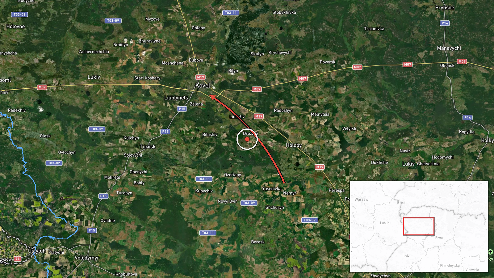
Ukrainian air monitoring reported on Telegram that one Russian jet-powered Shahed drone, described in the post as a Geran-3, was moving toward Kovel in Volyn Oblast in northwestern Ukraine. The post is timestamped 01:27 UTC on 20 October 2026. The original Ukrainian wording describes a jet drone approaching Kovel from the east, while the structured summary places the drone's origin in Volyn Oblast. The two descriptions differ on direction and origin, and that difference should be kept in mind. The report is a transit notice rather than a confirmed impact. It does not describe damage, casualties, or interception. The attribution to Russia rests on the Shahed design family, not on a separate claim of responsibility.
Context and assessment
Kovel is a mid-sized city in Volyn Oblast and an important railway junction in northwestern Ukraine, which gives it logistical significance beyond its population. The city sits in a region that has seen repeated drone tracks through the western oblasts. The related events in this data set show a sustained pattern. On 19 October, a report described two or more jet-powered Shahed drones heading toward Kovel at 14:00 UTC. Later that day, single-drone tracks were reported toward Kivertsi at 07:08 and toward Volodymyr-Volynskyi at 18:11, the latter from Volyn Oblast. Early on 20 October, a drone was reported toward Lutsk at 00:12, another from Rivne Oblast toward Volyn Oblast at 01:16, and then the Kovel track at 01:27. The sequence suggests drones entering or routed along a northern and western corridor, with several tracks passing through or near the same cluster of settlements within about twenty-four hours. Operationally, this pattern may indicate routing through the region toward targets further west, reconnaissance of air defence coverage, or saturation tactics. None of the related reports identifies a specific intended target, so these readings remain tentative.
Sources and confidence
This event rests on a single Telegram channel, @kpszsu, which is widely treated as an official Ukrainian air alert source. The confidence score of 8.0 reflects that institutional role, the precise timestamp, and the consistency of the report with a series of similar tracks in related events. However, there is no independent cross-confirmation, no second monitoring source, and no subsequent impact or wreckage report in the data. Confidence would rise if other official alert channels, regional administrations, or independent flight-tracking analysts corroborated the track and its direction. It would fall if later updates revised the origin or route, or if the wording discrepancy between direction and origin were not resolved. The record is not marked as corrected.
Location
The location is recorded at settlement level for Kovel, Ukraine, with high location confidence and coordinates of approximately 51.215 N, 24.701 E. These coordinates represent the city rather than a specific facility, so they do not indicate a particular target. Kovel lies in northwestern Ukraine within Volyn Oblast, in a region relatively close to the Belarusian border. The Turiya River passes through the city, and its rail junction is a notable feature of the surrounding landscape.
Related events nearby
- Ukrainian air monitoring: 2+ Russian jet-powered Shahed (Geran-3) drones heading toward Kovel.2026-10-19 14:00 UTC · Drone Transit · Kovel, Ukraine
- Ukrainian air monitoring: 1 Russian jet-powered Shahed (Geran-3) drone from Volyn Oblast toward Volodymyr-Voly2026-10-19 18:11 UTC · Drone Transit · Volodymyr-Volynskyi, Ukraine
- Ukrainian air monitoring: 1 Russian jet-powered Shahed (Geran-3) drone heading toward Kivertsi.2026-10-19 07:08 UTC · Drone Transit · Kivertsi, Ukraine
- Ukrainian air monitoring: 1 Russian jet-powered Shahed (Geran-3) drone from Rivne Oblast toward Volyn Oblast.2026-10-20 01:16 UTC · Drone Transit · Volyn Oblast, Ukraine
- Ukrainian air monitoring: 1 Russian jet-powered Shahed (Geran-3) drone heading toward Lutsk.2026-10-20 00:12 UTC · Drone Transit · Lutsk, Ukraine
▶ View this event on the live map

Intel Mapper aggregates open-source reports from monitored Telegram and X channels, geolocates them, cross-checks duplicates across sources and assigns a confidence score. Entries are updated as new confirmations arrive. Read how we verify events.