Single jet-powered Shahed drone reported moving from Zhytomyr toward Rivne Oblast
What happened
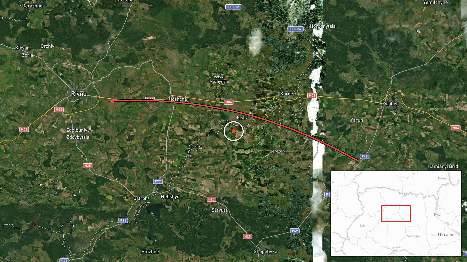
Ukrainian air monitoring channel @kpszsu reported at 01:44 UTC on 20 October 2026 that one Russian jet-powered Shahed (Geran-3) drone was flying past Horodnytsia in Zhytomyr Oblast and moving on toward Rivne Oblast. The post is a short, real-time monitoring notice. Its original wording, a motorcycle emoji followed by a phrase meaning 'reactive UAV past Horodnytsia in Zhytomyr region, heading to Rivne region', describes a transit track rather than an impact. The report names no damage, casualties, interception or target. Attribution to Russia rests on the channel's identification of the drone type as a Geran-3, the jet-powered variant of the Shahed family. The event was logged as a drone transit, and the feed contains five follow-on entries from the same hour.
Context and assessment
Rivne Oblast sits in northwestern Ukraine, close to the Polish and Belarusian borders, and the city of Rivne is a regional administrative centre. Its position makes it a plausible reference point for drones routed through the north-west, away from the more frequently struck eastern and southern regions, and the feed shows that pattern. Five related entries span 00:47 to 01:50 UTC, all describing Geran-3 drones heading toward Rivne, with one earlier entry noting a track passing Berezne, a Rivne Oblast town. Reported counts rise from one to two or more over that period, which suggests either successive launches or a group moving through the same corridor. The sequence is consistent with a sustained transit campaign in which drones cross Zhytomyr and Rivne airspace in staggered waves. Possible purposes include probing air defence coverage, forcing mobile fire group repositioning, or reaching distant targets in the west. None of the related entries reports impacts, and they describe headings rather than confirmed targets, so these readings remain tentative. The mid-night timing and repeated references to Rivne point to a coordinated effort rather than a single stray track.
Sources and confidence
Only one source is attached: the Telegram channel @kpszsu, which posts Ukrainian air monitoring alerts. No independent outlet, radar feed or second channel is recorded for this entry, so cross-confirmation is absent. The confidence score of 8.0 is relatively high for a single-channel report, reflecting the channel's role as an official-style monitoring source and the consistency of the surrounding feed, where five related entries describe the same drone type and direction. It is not higher because the post is a brief movement notice without imagery or follow-up. Confidence would rise with corroboration from Ukrainian air force statements, regional military administration posts or imagery. It would fall if later updates contradicted the heading or identified the object as a decoy or a different type.
Location
The location is recorded at region precision with low location confidence, meaning the point marks Rivne Oblast rather than a specific settlement or facility. The stored coordinates, 50.62 N and 26.25 E, sit at or near the city of Rivne, so the map marker should be read as an approximation of the wider area, not a precise site. The original post names Horodnytsia in Zhytomyr Oblast as the track's earlier reference, and Berezne is a Rivne Oblast town on the route. The terrain is largely flat Polissia lowland, with forests and marshes to the north.
Related events nearby
- Ukrainian air monitoring: 2+ Russian jet-powered Shahed (Geran-3) drones heading toward Rivne.2026-10-20 01:50 UTC · Drone Transit · Rivne, Ukraine
- Ukrainian air monitoring: 1 Russian jet-powered Shahed (Geran-3) drone heading toward Rivne.2026-10-20 01:43 UTC · Drone Transit · Rivne, Ukraine
- Ukrainian air monitoring: 2+ Russian jet-powered Shahed (Geran-3) drones heading toward Rivne.2026-10-20 01:09 UTC · Drone Transit · Rivne, Ukraine
- Ukrainian air monitoring: 1 Russian jet-powered Shahed (Geran-3) drone heading toward Rivne.2026-10-20 00:54 UTC · Drone Transit · Rivne, Ukraine
- Ukrainian air monitoring: 1 Russian jet-powered Shahed (Geran-3) drone passing Berezne, heading toward Rivne.2026-10-20 00:47 UTC · Drone Transit · Rivne, Ukraine
▶ View this event on the live map

Intel Mapper aggregates open-source reports from monitored Telegram and X channels, geolocates them, cross-checks duplicates across sources and assigns a confidence score. Entries are updated as new confirmations arrive. Read how we verify events.