Jet-powered Shahed drones reported moving west toward Kyiv Oblast near Olyshivka
What happened
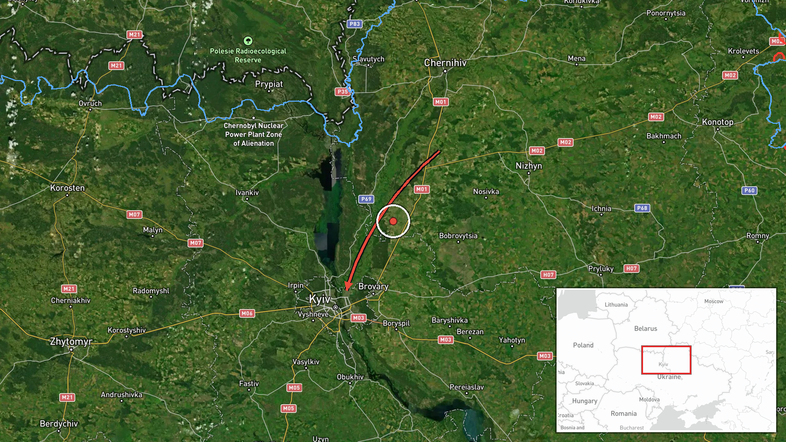
Ukraine's Telegram channel @kpszsu, which relays Ukrainian air monitoring, reported on 21 October 2026 at 07:58 UTC that two or more jet-powered Shahed (Geran-3) drones were flying on a western course in the area of the settlements of Hončarivske and Olyshivka, heading toward Kyiv Oblast. The original Ukrainian wording places the drones in Chernihiv region (Чернігівщина) before they continue toward Kyiv Oblast, while the event record lists the location as Kyiv Oblast. The report does not describe any impact, casualties, or interception. Because the message is a short monitoring update, the drones' altitude, exact numbers, and final destination are not specified beyond the stated heading.
Context and assessment
This report is one of several Drone Transit entries for the Kyiv area over roughly eighteen hours. Earlier on 20 October, at 17:18, two or more Geran-3 drones were reported passing Boryspil toward Kyiv, and at 17:32 a similar group was reported passing Olyshivka toward Kyiv Oblast. Overnight, single drones and groups of two or more were reported over Kyiv at 02:25 and 02:37, and at 03:43 another single drone was reported heading toward the city. The repetition suggests sustained or repeated launches, or monitoring of several approach corridors, rather than a single isolated flight. A westward track from the Chernihiv direction is consistent with routes approaching the capital from the north and northeast, which is widely known from earlier campaigns. The jet-powered Geran-3 variant is generally faster than the piston-engined Geran-2, which can shorten the warning time available to air defence crews. These inferences are tentative, since the monitoring messages do not give targets, altitudes, or intercept results, and the pattern may also reflect reporting density rather than a change in the size of attacks.
Sources and confidence
The event rests on a single Telegram channel, @kpszsu, which is widely associated with Ukrainian air monitoring messages. No second independent channel, wire service, or official statement in the data confirms this specific sighting, and the related events come from the same type of monitoring feed. The confidence score of 8.0 reflects a credible, specific, and recent source with clear heading information, offset by the single-channel basis and the absence of cross-confirmation. Confidence would rise with corroboration from another monitoring source, an Air Force statement, or wire reporting of the same track. It would fall if later updates revised the drone count, direction, or location, or if the channel issued a correction.
Location
The location was assigned at region level with low confidence, meaning the coordinates identify a general area rather than a precise point. The listed coordinates (50.45, 30.52) lie near central Kyiv and appear to serve as a regional reference point. The named settlements, Hončarivske and Olyshivka, are place names that may match more than one locality in Ukraine, so the mapping is approximate. The area is flat northern Ukrainian terrain on the boundary of Chernihiv and Kyiv oblasts, with the Desna and Dnipro river valleys nearby.
Related events nearby
- Ukrainian air monitoring: 1 Russian jet-powered Shahed (Geran-3) drone heading toward Kyiv.2026-10-21 03:43 UTC · Drone Transit · Kyiv, Ukraine
- Ukrainian air monitoring: 2+ Russian jet-powered Shahed (Geran-3) drones over Kyiv.2026-10-21 02:37 UTC · Drone Transit · Kyiv, Ukraine
- Ukrainian air monitoring: 1 Russian jet-powered Shahed (Geran-3) drone over Kyiv.2026-10-21 02:25 UTC · Drone Transit · Kyiv, Ukraine
- Ukrainian air monitoring: 2+ Russian jet-powered Shahed (Geran-3) drones passing Olyshivka, heading toward Kyi2026-10-20 17:32 UTC · Drone Transit · Kyiv Oblast, Ukraine
- Ukrainian air monitoring: 2+ Russian jet-powered Shahed (Geran-3) drones passing Boryspil, heading toward Kyiv2026-10-20 17:18 UTC · Drone Transit · Kyiv, Ukraine
▶ View this event on the live map

Intel Mapper aggregates open-source reports from monitored Telegram and X channels, geolocates them, cross-checks duplicates across sources and assigns a confidence score. Entries are updated as new confirmations arrive. Read how we verify events.