Ukrainian air monitoring reports jet-powered Shahed drone heading toward Lviv Oblast
What happened
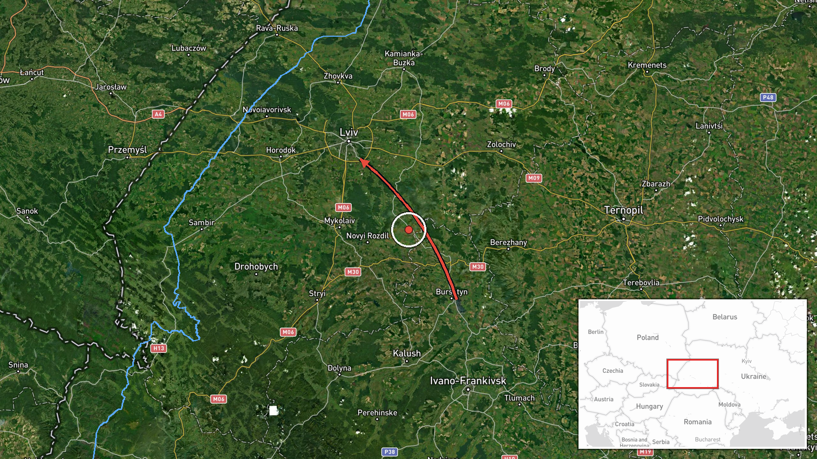
Ukraine's Air Force monitoring channel on Telegram, @kpszsu, reported on 21 October 2026 at 18:46 UTC that a jet-powered Russian Shahed-type drone, identified in the alert as a Geran-3, was moving on a course from a point north of Ivano-Frankivsk toward Lviv Oblast in western Ukraine. The original Ukrainian-language post was brief, describing a jet-powered UAV north of Ivano-Frankivsk heading toward the Lviv region. It did not mention impact, damage, or interception. The entry is a route-tracking notice rather than a confirmed strike. The origin point is described only approximately, and the actor is attributed to Russia based on the Geran designation used in the alert.
Context and assessment
This notice is one of five drone-transit alerts logged across Lviv Oblast on the same day. Earlier entries at 02:17 and 02:18 UTC tracked drones from northern Lviv Oblast and from Volyn Oblast toward Sosnivka and Zhovkva, and a later one at 17:10 UTC tracked a drone heading toward Lviv city. The sequence suggests either several separate drones or a sustained wave crossing the western oblasts over roughly sixteen hours. Lviv matters because it is the regional capital and a rail and road junction close to the Polish border, a key node for logistics and transit in western Ukraine. The data does not show what, if anything, the drones were aimed at. Operationally, the repeated tracks converging on the Lviv corridor may indicate routing toward targets further west or the use of decoys to saturate air defences, but the notice alone cannot confirm either explanation. The jet-powered Geran-3 variant is faster than propeller-driven versions, which can shorten the warning window for mobile fire groups. The repeated use of the word transit suggests drones passing through the area rather than striking it.
Sources and confidence
The report comes from a single Telegram channel, @kpszsu, which relays Ukrainian Air Force monitoring. The related events are drawn from the same type of air-alert feed, so they add context on sequence and routing but do not independently confirm this specific track, and cross-confirmation is not established. The confidence score of 8.0 reflects the channel's role as an official monitoring source and the specificity of the designation, but it is reduced by the single-source status and the lack of corroboration from regional authorities or independent monitors. Confidence would rise with reports from Lviv regional officials, flight-tracking data, or confirmed impact details. It would fall if the alert were updated, retracted, or not matched by any later sightings.
Location
The location is recorded at regional level as Lviv Oblast. The coordinates, 49.84 north and 24.03 east, are an approximate centroid of the oblast rather than a settlement or facility, and the alert names no specific place for this track. The oblast borders Poland to the west, Volyn to the north, and Ivano-Frankivsk to the southeast, with the Carpathian foothills to the south. The terrain is a mix of plains, the Roztocze uplands, and foothills. Lviv city is the main nearby urban centre, and Zhovkva, to its northwest, appears in related alerts.
Related events nearby
- Ukrainian air monitoring: 1 Russian jet-powered Shahed (Geran-3) drone from northern Ivano-Frankivsk Oblast to2026-10-21 18:27 UTC · Drone Transit · Lviv Oblast, Ukraine
- Ukrainian air monitoring: 1 Russian jet-powered Shahed (Geran-3) drone heading toward Lviv.2026-10-21 17:10 UTC · Drone Transit · Lviv, Ukraine
- Ukrainian air monitoring: 1 Russian jet-powered Shahed (Geran-3) drone heading toward Zhovkva.2026-10-21 02:18 UTC · Drone Transit · Zhovkva, Ukraine
- Ukrainian air monitoring: 1 Russian jet-powered Shahed (Geran-3) drone from Volyn Oblast toward Sosnivka.2026-10-21 02:18 UTC · Drone Transit · Sosnivka, Ukraine
- Ukrainian air monitoring: 1 Russian jet-powered Shahed (Geran-3) drone from northern Lviv Oblast toward Sosniv2026-10-21 02:17 UTC · Drone Transit · Sosnivka, Ukraine
▶ View this event on the live map

Intel Mapper aggregates open-source reports from monitored Telegram and X channels, geolocates them, cross-checks duplicates across sources and assigns a confidence score. Entries are updated as new confirmations arrive. Read how we verify events.