Single jet-powered Geran-3 drone reported moving from Kirovohrad Oblast toward Cherkasy Oblast, Ukraine
What happened
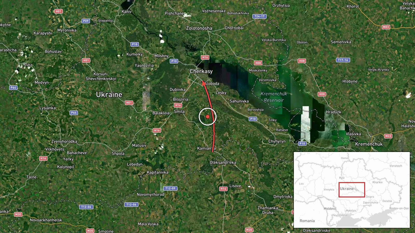
Ukrainian air monitoring reported on 22 October 2026 at 07:17 UTC that one Russian jet-powered Shahed, designated Geran-3, was moving from Kirovohrad Oblast toward Cherkasy Oblast in central Ukraine. The report was posted as a short Ukrainian-language alert on Telegram under the handle @kpszsu. The wording describes a jet-powered unmanned aerial vehicle on a stated heading, giving a direction of travel rather than a point of impact or a named settlement. The source describes no strike, damage, or casualties. The event is classified as a drone transit, meaning the object was tracked in flight over the region. The alert rests on a single channel, and the dataset holds no independent confirmation.
Context and assessment
Cherkasy Oblast appears repeatedly in this sequence. Related entries from 21 October show drones crossing the oblast from several directions. At 08:54 UTC two or more Geran-3 drones were reported leaving Kirovohrad Oblast toward Cherkasy Oblast. At 14:08 one was reported from western Poltava Oblast toward the same destination, and at 18:33 one departed Cherkasy Oblast toward Horodyshche, a town within it. A Ukrainian Navy mobile fire group reported destroying a Shahed at 14:20 UTC using a Sting interceptor drone, though no location was given. The same day, an all-clear ended a ballistic missile threat reportedly launched from Voronezh, Russia. Taken together, the pattern suggests repeated routing of jet-powered drones across central Ukraine, with Cherkasy Oblast lying on a corridor between northeastern and western approaches. Such transits are typically tracked to warn of possible targets further along the route, which may include infrastructure in central or western regions, although these reports do not identify targets. The Geran-3 is a jet-powered variant generally understood to fly faster than piston-engined Shahed models, which can shorten warning times and complicate interception. The sequence most likely reflects sustained long-range drone activity rather than a single isolated raid.
Sources and confidence
The item rests on one channel, Telegram (@kpszsu), with a source count of one. No second outlet, official statement, wire report, or independent tracking record in the dataset corroborates it. The confidence score of 8.0 reflects a routine, credible monitoring channel and a clearly defined event type, not multi-source verification, so it stays below the top of the scale. Confidence would rise with a parallel air force or regional military administration post, or with independent radar or open-source flight tracking. It would fall if later updates contradicted the reported heading or if the attribution to Russia and the drone type were revised.
Location
The location is coded at region level, Cherkasy Oblast, with low location confidence. The coordinates (49.44, 32.06) mark an approximate point within the oblast rather than a settlement, facility, or impact site, because the source names no town. Cherkasy Oblast lies in central Ukraine along the Dnipro River, an area of agricultural land and river terrain. Treat the pin as a general area marker for a transit, not as a target location.
Related events nearby
- Ukrainian air monitoring: 1 Russian jet-powered Shahed (Geran-3) drone from western Poltava Oblast toward Cher2026-10-21 14:08 UTC · Drone Transit · Cherkasy Oblast, Ukraine
- Ukrainian air monitoring: 2+ Russian jet-powered Shahed (Geran-3) drones from Kirovohrad Oblast toward Cherkas2026-10-21 08:54 UTC · Drone Transit · Cherkasy Oblast, Ukraine
- Ukrainian Navy mobile fire group Sargan 3000 destroyed a Russian Shahed drone using the Sting interceptor dron2026-10-21 14:20 UTC · Air Defense · Ukraine (location not reported)
- Ukrainian air monitoring: 1 Russian jet-powered Shahed (Geran-3) drone from Cherkasy Oblast toward Horodyshche2026-10-21 18:33 UTC · Drone Transit · Horodyshche, Ukraine
- Ukrainian air monitoring announces all-clear, ending the ballistic missile threat reportedly launched from Vor2026-10-21 19:59 UTC · Siren · Ukraine (location not reported)
▶ View this event on the live map

Intel Mapper aggregates open-source reports from monitored Telegram and X channels, geolocates them, cross-checks duplicates across sources and assigns a confidence score. Entries are updated as new confirmations arrive. Read how we verify events.