Russian jet-powered Shahed drone reported moving from Poltava toward Cherkasy Oblast
What happened
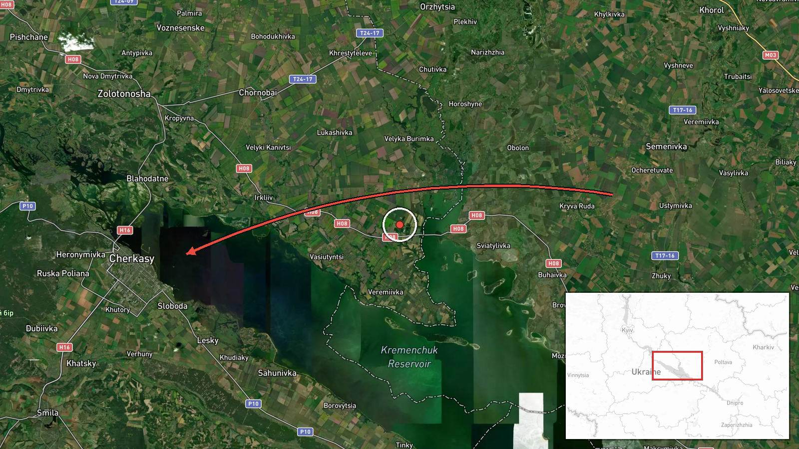
Ukrainian air monitoring reported one Russian jet-powered Shahed drone, identified as the Geran-3, moving from western Poltava Oblast toward Cherkasy Oblast on 21 October 2026, with the report timestamped 14:08 UTC. The only source is a Telegram post from the channel @kpszsu, which carries Ukrainian air monitoring updates. The original Ukrainian wording is brief, describing a jet-type UAV in the west of Poltava region on a course toward Cherkasy region. It gives no altitude, speed, or intended target. No impact, casualty, or damage details are included. The report describes a transit rather than a confirmed strike, and the drone's final position or outcome is not stated in this entry.
Context and assessment
Cherkasy Oblast sits on the Dnipro River in central Ukraine, an area that lies along air corridors between the eastern front, Kyiv, and western Ukraine, so drones crossing it are routinely tracked. This entry is one of several same-day transits. Earlier, at 06:26 UTC, the monitoring channel reported two or more Shaheds from Poltava Oblast toward Cherkasy, and at 08:54 UTC two or more from Kirovohrad Oblast toward Cherkasy. The oblast was therefore a repeated track through the morning. A mass overnight attack at 05:36 UTC involved Iskander-K cruise missiles and 186 drones, with Ukrainian air defense reporting 150 downed. At 14:20 UTC a Ukrainian Navy mobile fire group, Sargan 3000, reportedly destroyed a Shahed using a Sting interceptor drone, though the location was not given. Operationally, repeated transits from different directions could indicate routing toward targets beyond or within Cherkasy, or a saturation pattern meant to stretch air defense. The jet-powered Geran-3 is faster than piston-engine Shaheds, which shortens warning time. These readings are inferences, not confirmed intent.
Sources and confidence
All information comes from one Telegram channel, @kpszsu, with no cross-confirmation from other outlets or official statements in the available data. The confidence score of 8.0 reflects that the channel publishes routine air monitoring and that its same-morning reports are consistent with each other, but it remains single-source and its location is only regional. Confidence would rise with corroboration from additional monitoring channels, official statements, or geolocated debris or video from the area. It would fall if the channel corrected or retracted the post, or if later reports placed the drone in a different oblast.
Location
The coordinates, 49.44 N and 32.06 E, are an approximate region-level point for Cherkasy Oblast rather than a settlement or facility, and the location confidence is recorded as low. The oblast lies in central Ukraine, where the Dnipro River flows through farmland, forest belts, and river valleys. Cherkasy city is on the Dnipro. Poltava and Kirovohrad Oblasts border it to the east and northwest respectively, which matches the reported approach routes.
Related events nearby
- Ukrainian air monitoring: 2+ Russian jet-powered Shahed (Geran-3) drones from Kirovohrad Oblast toward Cherkas2026-10-21 08:54 UTC · Drone Transit · Cherkasy Oblast, Ukraine
- Ukrainian air monitoring: 2+ Russian jet-powered Shahed (Geran-3) drones from Poltava Oblast toward Cherkasy O2026-10-21 06:26 UTC · Drone Transit · Cherkasy Oblast, Ukraine
- Ukrainian Navy mobile fire group Sargan 3000 destroyed a Russian Shahed drone using the Sting interceptor dron2026-10-21 14:20 UTC · Air Defense · Ukraine (location not reported)
- Russia launched a mass overnight attack with Iskander-K cruise missiles and 186 drones, including jet Shaheds.2026-10-21 05:36 UTC · Cruise Missile · Ukraine (location not reported)
- WSJ reports Elon Musk ordered Starlink service speeds in Ukraine to be throttled, affecting Ukrainian military2026-10-20 23:34 UTC · Report · Ukraine
▶ View this event on the live map

Intel Mapper aggregates open-source reports from monitored Telegram and X channels, geolocates them, cross-checks duplicates across sources and assigns a confidence score. Entries are updated as new confirmations arrive. Read how we verify events.