Jet-powered Shahed drones reported transiting Poltava toward Cherkasy and Kyiv regions
What happened
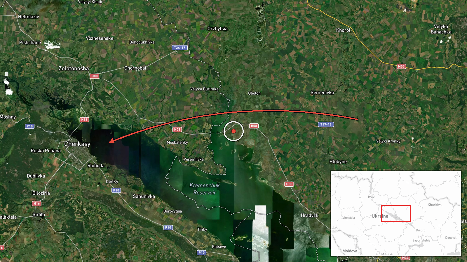
Ukrainian air monitoring, as relayed by the Telegram channel @kpszsu, reported at least two Russian jet-powered Shahed drones, designated Geran-3 in the report, moving from Poltava Oblast into Cherkasy Oblast on 21 October 2026 at about 06:26 UTC. The original Ukrainian-language post describes the drones as moving in a direction toward Kyiv region, which suggests the track was heading further north rather than ending in Cherkasy. The post describes no impact, target, or damage, and it does not state how many drones were ultimately tracked or whether any were intercepted. The event is logged as a drone transit rather than a strike. It falls within a broader overnight attack reported roughly fifty minutes earlier that involved cruise missiles and a large number of drones.
Context and assessment
Cherkasy Oblast lies on the right bank of the Dnipro in central Ukraine, and Poltava Oblast borders it to the east. Drones passing through this area are on a plausible north-westward line toward the Kyiv region, a route that has seen repeated activity in recent days. Related entries show a consistent pattern. At 17:04 UTC on 20 October, the same channel reported two or more jet-powered Geran-3 drones moving from Cherkasy Oblast toward Pereiaslav, a town in Kyiv Oblast. At 02:17 UTC on 21 October, a single jet-powered Geran-3 was reported over Pereiaslav. Shortly before this transit, a mass overnight attack was reported with Iskander-K cruise missiles and 186 drones, with 150 reportedly downed. Operationally, the pattern may indicate that jet-powered drones are being routed along the Dnipro axis toward Kyiv, possibly as part of a larger combined package. Jet-powered variants are generally faster than propeller-driven Shaheds, which can shorten warning times. These inferences rest on a small number of single-channel reports and should be treated as provisional.
Sources and confidence
The report comes from a single Telegram channel, @kpszsu, which is associated with Ukraine's Air Force, and no independent outlet or second channel is listed for this specific track. The confidence score of 8.0 reflects the channel's official character and its consistency with related reports of the same drone type in the same corridor. It does not reflect independent confirmation of this exact route. The location confidence is rated low because the track is described at regional level only. Confidence would rise with a second Ukrainian official statement, independent radar or open-source tracking, or a later report confirming where the drones were detected or destroyed. It would fall if Ukrainian authorities revised the track or if no further sightings emerged.
Location
The location is recorded at regional level. The coordinates, 49.44 north and 32.06 east, approximate the general centre of Cherkasy Oblast rather than a specific settlement, facility, or point on the drone's path. No origin point is given, so the route is inferred from the description of movement between Poltava and Cherkasy. The terrain is mainly flat steppe and farmland, with the Dnipro River and its reservoirs forming the main geographic feature. Pereiaslav, the town named in related reports, lies to the north in Kyiv Oblast.
Related events nearby
- Russia launched a mass overnight attack with Iskander-K cruise missiles and 186 drones, including jet Shaheds.2026-10-21 05:36 UTC · Cruise Missile · Ukraine (location not reported)
- Footage shows a Ukrainian interceptor drone downing a Russian Geran-2 loitering munition; location not reporte2026-10-20 10:11 UTC · Drone Shootdown · Ukraine (location not reported)
- WSJ reports Elon Musk ordered Starlink service speeds in Ukraine to be throttled, affecting Ukrainian military2026-10-20 23:34 UTC · Report · Ukraine
- Ukrainian air monitoring: 1 Russian jet-powered Shahed (Geran-3) drone over Pereiaslav.2026-10-21 02:17 UTC · Drone Transit · Pereiaslav, Ukraine
- Ukrainian air monitoring: 2+ Russian jet-powered Shahed (Geran-3) drones from Cherkasy Oblast toward Pereiasla2026-10-20 17:04 UTC · Drone Transit · Pereiaslav, Ukraine
▶ View this event on the live map

Intel Mapper aggregates open-source reports from monitored Telegram and X channels, geolocates them, cross-checks duplicates across sources and assigns a confidence score. Entries are updated as new confirmations arrive. Read how we verify events.