Jet-powered Shahed drones reported from Cherkasy Oblast toward Pereiaslav, Kyiv Oblast
What happened
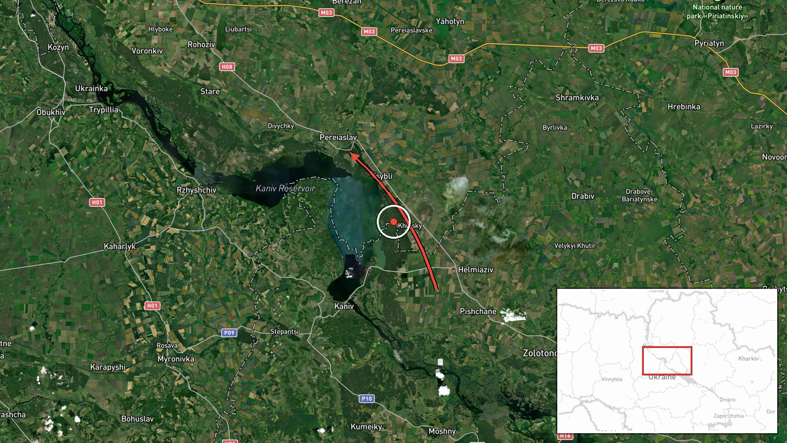
On 20 October 2026 at 17:04 UTC, the Telegram channel of Ukraine's Air Force (@kpszsu) reported jet-powered Shahed-type drones, identified as Geran-3, moving through Cherkasy Oblast in the direction of Kyiv Oblast, with Pereiaslav named as the target area. The original Ukrainian wording describes jet-powered unmanned aerial vehicles passing through the Cherkasy region toward the Kyiv region, and the English summary refers to at least two drones. The notice is a short air-monitoring message rather than a description of impact. It does not state any strike, damage, casualties, or interception outcome. Earlier notices the same day tracked similar groups heading toward Pereiaslav and Boryspil, and a General Staff summary covering the preceding 24 hours counted thousands of kamikaze drones across Ukraine. Readers should treat this record as a transit warning rather than a confirmed attack on the town.
Context and assessment
Pereiaslav lies in Kyiv Oblast, roughly 50 kilometres southeast of the capital, on the Trubizh river. Its significance here lies less in the town itself than in its position along a corridor linking Cherkasy Oblast with the Kyiv region and the Boryspil area, where the international airport and major logistics nodes are located. The related events show a sequence on the same afternoon. A group of two or more drones was reported passing Pereiaslav toward Boryspil at 11:49, a single drone was reported heading toward Pereiaslav around 13:27, and further groups of two or more were reported toward Pereiaslav at 15:45 and toward Boryspil at 15:50. The repetition suggests several drone movements crossing the same axis over several hours, which is consistent with routing that may target multiple points in the capital region rather than one fixed site. Operationally, transit notices of this kind usually indicate that air defence and mobile fire groups are being alerted along a route. They cannot establish the final target or show whether drones were diverted or destroyed. The jet-powered variant is generally associated with higher speed than piston-engined Shaheds, which would shorten warning times for those on the ground.
Sources and confidence
The event rests on a single channel, the official Telegram account of Ukraine's Air Force, with no independent cross-confirmation recorded in the dataset. The confidence score of 8.0 reflects an official military monitoring source, a consistent sequence of related notices on the same axis, and an explicit geographic path. It is held below the top range because of reliance on one channel and the absence of any impact or interception confirmation. Confidence would rise with corroboration from Kyiv Oblast or Cherkasy Oblast military administrations, follow-up Air Force updates, or independent flight-tracking data. It would fall if later official messages revised the route, reported the drones as diverted, or withdrew the warning.
Location
The coordinates correspond to the settlement of Pereiaslav and were assigned at settlement precision with high location confidence. The point marks the town rather than any specific facility or target. Pereiaslav sits in Kyiv Oblast on the Trubizh river close to its junction with the Dnipro, on largely flat terrain of river valleys, farmland and wooded patches. Boryspil lies to the southeast of Kyiv, and Cherkasy Oblast borders the region to the south. The origin is recorded only as the oblast, with no specific launch point.
Related events nearby
- Ukrainian air monitoring: 2+ Russian jet-powered Shahed (Geran-3) drones heading toward Pereiaslav.2026-10-20 15:45 UTC · Drone Transit · Pereiaslav, Ukraine
- Ukrainian air monitoring: 1 Russian jet-powered Shahed (Geran-3) drone heading toward Pereiaslav; 1 Russian je2026-10-20 13:27 UTC · Drone Transit · Pereiaslav, Ukraine
- Ukrainian air monitoring: 2+ Russian jet-powered Shahed (Geran-3) drones heading toward Boryspil.2026-10-20 15:50 UTC · Drone Transit · Boryspil, Ukraine
- Ukrainian air monitoring: 2+ Russian jet-powered Shahed (Geran-3) drones passing Pereiaslav, heading toward Bo2026-10-20 11:49 UTC · Drone Transit · Boryspil, Ukraine
- Ukrainian General Staff reports 24h Russian attacks: 1 missile strike, 63 airstrikes, 217 guided glide bombs, 2026-10-20 04:07 UTC · Report · Ukraine
▶ View this event on the live map

Intel Mapper aggregates open-source reports from monitored Telegram and X channels, geolocates them, cross-checks duplicates across sources and assigns a confidence score. Entries are updated as new confirmations arrive. Read how we verify events.