Jet-powered Shahed drone reported moving toward Horodyshche in Cherkasy Oblast, Ukraine
What happened
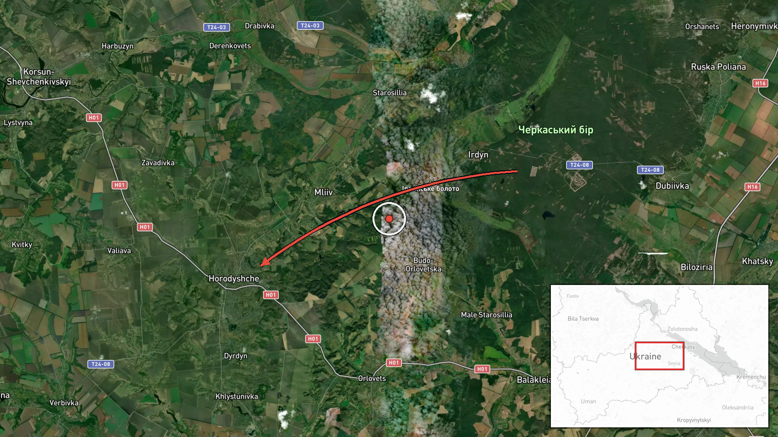
Ukrainian air monitoring reported one Russian jet-powered Shahed drone, identified in the source as a Geran-3, flying toward the town of Horodyshche in Cherkasy Oblast, central Ukraine. The report is timestamped 21 October 2026 at 18:33 UTC and describes the drone as approaching from the south. The original Ukrainian-language post reads roughly as a jet-powered UAV heading for Horodyshche from the south in the Cherkasy region. The alert concerns a single aircraft and does not describe impacts, damage, or casualties. It was published on the Telegram channel @kpszsu, and no independent outlet in the dataset corroborates it.
Context and assessment
Cherkasy Oblast sits on the route between Russian-attacked areas in the south and east and the central and western parts of Ukraine, so drones crossing it are a recurring feature of the air campaign. The related entries show a sequence of inbound tracks through the oblast over the same day. At 08:54 UTC, two or more jet-powered Shaheds were reported moving from Kirovohrad Oblast toward Cherkasy Oblast. At 14:08, one was reported moving from western Poltava Oblast toward Cherkasy Oblast. The Horodyshche report at 18:33 fits that pattern. Earlier, at 05:36, Russia reportedly launched a mass overnight attack with Iskander-K cruise missiles and 186 drones, and Ukrainian air defense reportedly downed 150. At 14:20, a Ukrainian Navy mobile fire group reportedly destroyed a Shahed using a Sting interceptor drone, though the location was not specified. Operationally, a single drone tracked toward a named settlement may indicate a flight corridor, a selected target, or a decoy. Individual tracks reported in sequence across several oblasts more often reflect ongoing drone flows than one planned strike. The reports alone cannot show which of these applies.
Sources and confidence
The item rests on one Telegram channel, @kpszsu, which is the only source listed. Its confidence score of 8.0 reflects a consistent format, a precise timestamp, and fit with other same-day monitoring reports in the dataset. It is held below the top band because no second channel, official statement, or impact report confirms the track. Confidence would rise with corroboration from additional Ukrainian air force or regional military administration posts, or with reports of a shoot-down or impact in Horodyshche. It would fall if later updates place the drone elsewhere, report it downed away from the settlement, or contradict the reported direction of approach.
Location
The coordinates, about 49.291 north and 31.440 east, place the marker on the town of Horodyshche itself. The location is marked high confidence at settlement precision, meaning the point marks the settlement and not a specific facility or street. Horodyshche lies in Cherkasy Oblast in central Ukraine, within the Dnipro river basin. The surrounding terrain is largely agricultural plains, and the wider oblast contains the regional center of Cherkasy, which lies to the east. The dataset does not identify any particular facility near the marker.
Related events nearby
- Ukrainian Navy mobile fire group Sargan 3000 destroyed a Russian Shahed drone using the Sting interceptor dron2026-10-21 14:20 UTC · Air Defense · Ukraine (location not reported)
- Russia launched a mass overnight attack with Iskander-K cruise missiles and 186 drones, including jet Shaheds.2026-10-21 05:36 UTC · Cruise Missile · Ukraine (location not reported)
- WSJ reports Elon Musk ordered Starlink service speeds in Ukraine to be throttled, affecting Ukrainian military2026-10-20 23:34 UTC · Report · Ukraine
- Ukrainian air monitoring: 1 Russian jet-powered Shahed (Geran-3) drone from western Poltava Oblast toward Cher2026-10-21 14:08 UTC · Drone Transit · Cherkasy Oblast, Ukraine
- Ukrainian air monitoring: 2+ Russian jet-powered Shahed (Geran-3) drones from Kirovohrad Oblast toward Cherkas2026-10-21 08:54 UTC · Drone Transit · Cherkasy Oblast, Ukraine
▶ View this event on the live map

Intel Mapper aggregates open-source reports from monitored Telegram and X channels, geolocates them, cross-checks duplicates across sources and assigns a confidence score. Entries are updated as new confirmations arrive. Read how we verify events.