Single Russian jet-powered Shahed drone reported moving from northern Zhytomyr toward northern Rivne Oblast
What happened
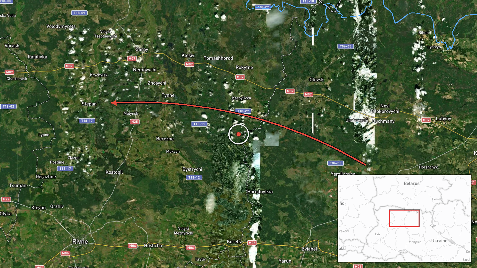
On 22 October 2026 at about 07:17 UTC, a Ukrainian air monitoring channel, Telegram account @kpszsu, reported one Russian jet-powered Shahed (Geran-3) drone travelling from northern Zhytomyr Oblast toward northern Rivne Oblast in western Ukraine. The original post, written in Ukrainian, describes a jet-type unmanned aerial vehicle moving from the north of Zhytomyr region to the north of Rivne region. The report is a transit notice rather than a strike report: it does not describe an impact, a target, or casualties. The event is recorded as a single-source report, and the summary attributes the drone to Russia based on the type designation used by Ukrainian monitoring.
Context and assessment
Northern Rivne and Zhytomyr oblasts sit in western and north-central Ukraine, along routes that Shahed-type drones have used to cross from the north and east toward western regions and toward the Polish and Belarusian borders. The related events show a sustained pattern over the previous day. Between 15:57 and 17:20 UTC on 21 October 2026, monitoring reports logged repeated single and multiple drone transits toward Rivne, with one group of at least two drones from northern Zhytomyr heading toward Rivne Oblast and another passing eastern Volyn Oblast heading west. The clustering suggests a series of drones entering or moving through the northwest corridor over several hours rather than isolated incidents. The reports do not name specific targets, so the purpose of these flights cannot be confirmed from the data. Transit tracking of this kind is typically used to give regional air defence and civil authorities warning, and the repeated Rivne mentions may indicate that the city or its surrounding area was a stated direction of travel. The jet-powered Geran-3 variant is generally considered faster than earlier piston-engined Shaheds, which shortens warning times.
Sources and confidence
The event rests on one Telegram channel, @kpszsu, which is the account associated with Ukrainian air monitoring reports. No second independent outlet is listed in the data as confirming this specific transit. The confidence score of 8.0 reflects a credible official-style monitoring source with a clear, specific report, offset by the absence of cross-confirmation and the single-channel basis. Confidence would rise if regional military administrations, the Air Force, or wire services reported the same track, or if debris, impact, or sirens in Rivne or Zhytomyr were independently documented. It would fall if later updates contradicted the direction of travel or if the drone's track could not be matched to the related events.
Location
The location is recorded at the regional level as northern Rivne Oblast, with coordinates near 51.165 N, 26.25 E, which is a general centroid rather than a settlement or facility. The report itself names only the directional path between northern Zhytomyr and northern Rivne, so the point should be read as approximate. Northern Rivne is largely flat to gently rolling terrain with forests, marshes, and river valleys, including the Polissia wetland belt. Rivne city lies to the south of the marked point.
Related events nearby
- Ukrainian air monitoring: 1 Russian jet-powered Shahed (Geran-3) drone heading toward Kostopil.2026-10-22 07:40 UTC · Drone Transit · Kostopil, Ukraine
- Ukrainian air monitoring: 2+ Russian jet-powered Shahed (Geran-3) drones passing eastern Volyn Oblast, heading2026-10-21 17:20 UTC · Drone Transit · eastern Volyn Oblast, Ukraine
- Ukrainian air monitoring: 2+ Russian jet-powered Shahed (Geran-3) drones from northern Zhytomyr Oblast toward 2026-10-21 17:11 UTC · Drone Transit · Rivne Oblast, Ukraine
- Ukrainian air monitoring: 1 Russian jet-powered Shahed (Geran-3) drone heading toward Rivne Oblast.2026-10-21 16:36 UTC · Drone Transit · Rivne Oblast, Ukraine
- Ukrainian air monitoring: 1 Russian jet-powered Shahed (Geran-3) drone heading toward Rivne.2026-10-21 16:02 UTC · Drone Transit · Rivne, Ukraine
▶ View this event on the live map

Intel Mapper aggregates open-source reports from monitored Telegram and X channels, geolocates them, cross-checks duplicates across sources and assigns a confidence score. Entries are updated as new confirmations arrive. Read how we verify events.