Single jet-powered Shahed drone reported heading from Black Sea toward Ochakiv, Mykolaiv Oblast
What happened
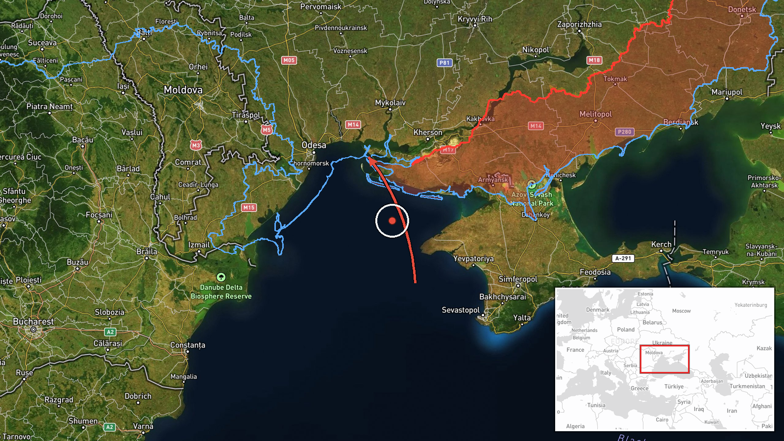
Ukrainian air monitoring reported on Telegram that one Russian jet-powered Shahed (Geran-3) drone was tracked moving from the Black Sea toward Ochakiv, a town in Mykolaiv Oblast in southern Ukraine. The event is dated 22 October 2026 at 08:35 UTC. The original post, from the channel @kpszsu, is a short Ukrainian-language alert describing a jet-type UAV ("реактивний БпЛА") approaching Ochakiv from the sea area. The report does not mention impact, damage, casualties, or interception. Because the alert is a monitoring notice rather than a description of an incident on the ground, the outcome of the drone's flight remains unrecorded.
Context and assessment
Ochakiv sits on the Dnipro-Buh estuary near the Black Sea coast, and the approach corridor from open water toward this area has been used repeatedly in recent drone activity. The related events show a clear pattern across the previous day and a half. On 21 October, monitoring reported two or more Geran-3 drones moving through Mykolaiv Oblast, first from the Black Sea and then heading north, followed by a single drone from Odesa Oblast tracked toward Raukhivka that same morning. Early on 22 October another single drone was reported passing the Mykolaiv district heading north, and this Ochakiv alert continues the sequence. The repeated northward tracks suggest routine long-range strike traffic moving along the coast toward inland targets, with Ochakiv and nearby settlements sitting along the route rather than being the sole objective. Operationally, the pattern may indicate probing or sustained pressure on air defence coverage in the south, though a monitoring alert alone cannot establish intent or target selection.
Sources and confidence
The event rests on a single Telegram channel, @kpszsu, which is the Ukrainian Air Force-linked monitoring account. No independent outlet, wire service, or second channel in the provided data corroborates the track. The confidence score of 8.0 reflects a credible official-style source with specific timing and a clear type designation, but it is held below the top range because it is single-sourced and reports only a trajectory, not confirmed impact. Confidence would rise with corroboration from regional military administration statements, a second monitoring channel, or a post-event report of interception or impact. It would fall if the track is later revised or the drone is attributed to a different airspace event.
Location
The location is tagged at settlement level for Ochakiv, Ukraine, with coordinates near 46.61 N, 31.55 E, and the location confidence is recorded as high. The alert names the town rather than a specific facility, so the point marks the settlement centre rather than any installation. Geographically, Ochakiv lies on the northern shore of the Black Sea approaches at the mouth of the Southern Bug estuary, with the Dnipro-Buh estuary and low-lying coastal terrain to its north and west.
Related events nearby
- Ukrainian air monitoring: 2+ Russian jet-powered Shahed (Geran-3) drones from Black Sea toward Mykolaiv Oblast2026-10-21 13:33 UTC · Drone Transit · Mykolaiv Oblast, Ukraine
- Ukrainian air monitoring: 2+ Russian jet-powered Shahed (Geran-3) drones passing Mykolaiv Oblast, heading nort2026-10-21 12:46 UTC · Drone Transit · Mykolaiv Oblast, Ukraine
- Ukrainian air monitoring: 1 Russian jet-powered Shahed (Geran-3) drone passing Mykolaiv district, heading nort2026-10-22 07:15 UTC · Drone Transit · Mykolaiv district, Ukraine
- Ukrainian air monitoring: 1 Russian jet-powered Shahed (Geran-3) drone from Odesa Oblast toward Raukhivka.2026-10-21 09:46 UTC · Drone Transit · Raukhivka, Ukraine
▶ View this event on the live map

Intel Mapper aggregates open-source reports from monitored Telegram and X channels, geolocates them, cross-checks duplicates across sources and assigns a confidence score. Entries are updated as new confirmations arrive. Read how we verify events.